Derry and Strabane
Coordinates: 54°55′37″N 7°25′26″W / 54.927°N 7.424°W
| Derry City and Strabane | |
|---|---|
| District | |
 | |
| Sovereign state | United Kingdom |
| Constituent country | Northern Ireland |
| Status | District |
| Incorporated | 1 April 2015 |
| Government | |
| • Type | District council |
| • Body | Derry and Strabane District Council |
| Time zone | GMT (UTC0) |
| • Summer (DST) | BST (UTC+1) |
| Website | http://www.derrycityandstrabanedistrict.com/ |
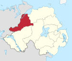
Derry City and Strabane is a local government district that was created on 1 April 2015 by merging the City of Derry District and Strabane District.[1] It covers most of the northwest of Northern Ireland. The local authority is Derry and Strabane District Council.
Geography
It is located in the northwest of Northern Ireland and include parts of counties Londonderry and Tyrone, and borders County Donegal in the Republic of Ireland.[2] The district has an electorate of 92,593.[3] The name of the new district was announced on 17 September 2008.
Northern Ireland Railways station
Derry and Strabane District Council
Derry City and Strabane District Council replaced Derry City Council and Strabane District Council. The first election for the new district was originally due to take place in May 2009, but in April 2008, Shaun Woodward, Secretary of State for Northern Ireland announced that the scheduled 2009 district council elections were to be postponed until 2011.[4] The first elections took place on 22 May 2014 and the council will acted as a shadow authority until 1 April 2015.
See also
References
- ↑ http://www.lgbc-ni.org/press_release_-_revised_recommendations_-_feb_v2.pdf
- ↑ http://www.lgbc-ni.org/introduction_compressed.pdf
- ↑ "Provisional Recommendations of the Local Government Boundaries Commissioner for Northern Ireland". LGBC. Retrieved 2008-09-26.
- ↑ Northern Ireland elections are postponed, BBC News, April 25, 2008, accessed April 27, 2008