Derby, Western Australia
| Derby Western Australia | |||||||
|---|---|---|---|---|---|---|---|
 This boab tree near Derby was actually used as a prison, hence the name the "Boab Prison Tree" | |||||||
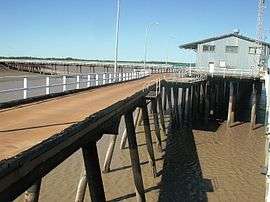 Low tide at the Derby wharf on King Sound | |||||||
 Derby | |||||||
| Coordinates | 17°21′0″S 123°41′0″E / 17.35000°S 123.68333°ECoordinates: 17°21′0″S 123°41′0″E / 17.35000°S 123.68333°E | ||||||
| Population | 4,865 (2011 census)[1] | ||||||
| Established | 1880s | ||||||
| Postcode(s) | 6728 | ||||||
| Elevation | 8 m (26 ft) | ||||||
| Location |
| ||||||
| LGA(s) | Shire of Derby-West Kimberley | ||||||
| State electorate(s) | Kimberley | ||||||
| Federal Division(s) | Durack | ||||||
| |||||||
Derby (/ˈdɜːrbi/ DERR-bee)[2] is a town in the Kimberley region of Western Australia. At the 2011 census, Derby had a population of 4,865, with about half of Aboriginal descent.[1] Along with Broome and Kununurra, it is one of only three towns in the Kimberley to have a population over 2,000. Located on King Sound, Derby has the highest tides in Australia, with the peak differential between low and high tide reaching 11.8 metres.[3]
History
During World War II, Derby was bombed by Japanese planes because of an air base and jetty that was steadily used by Australian forces. More recently, refugees were housed at Royal Australian Air Force Base Curtin, which of which the detention center was closed in 2014.[4]
Derby was famous in the 1920s as the terminus of the first scheduled aviation service in Australia, West Australian Airways Ltd. They began their service with a first flight on 5 December 1921. At one time the Perth to Derby service was the world’s longest passenger airline route.
In 1968 the town had a population of approximately 1,500 many employed at the meatworks. A A$900,000 beef road was completed from Glenroy Station to Derby was completed the same year to assist with the development of beef processing. A A$2 million steel and concrete jetty was built in 1965 to provide adequate port facilities for the shipment of live cattle.[5]
Culture
Derby is rich in cultural diversity, with the local Indigenous culture playing a large part in the community. The Mowanjum Festival is held annually at Mowanjum Community and features a showcase of traditional art.
The Boab festival is a week-long festival that includes traditional events such as mud football, watermelon seed spitting, the Mardi Gras and other festivities.[6]
Historically, Derby has played a major role in the Australian Royal Flying Doctor Service for the Kimberley Region. The Kimberley School of the Air is also located in Derby.
Derby has two other schools, Holy Rosary School Derby and Derby District High School. Derby District High School follows Chris Sarra's vision of 'Stronger Smarter', which aims to raise the expectations of the school as a community.
Wharfinger’s House museum tells the story of the aviation history of the town as well as the history of the Port....
Economy
There is employment in the pastoral and mining industries, as well as administration and tourism. There is oil at Blina, diamonds in the Phillips Range, stone is quarried from the King Leopold Ranges and lead and zinc from Cadjebut. In 1997 the Derby wharf, which was closed in the 1980s, was re-opened for barging operations for the export of lead and zinc.
The Derby Leprosarium on the outskirts of the town was one of two in Western Australia that helped to contain an epidemic of the disease from the 1930s to the 1960s.[7]
Climate
Derby has a hot semi-arid climate with a short, highly variable wet season lasting from late December to March. The wet season features hot, humid days and nights and erratic downpours. Some years there is no wet season whatsoever, however in others more than a years worth of rain can fall in a month. Derby can be affected by severe tropical cyclones from time to time. The dry season lasts from April to November and features very little rain, warm to hot daytime temperatures and mild to cool nights. Extreme temperatures have ranged from 48.4 °C (119.1 °F) to 6.0 °C (42.8 °F), while the wettest month on record was January 1917 when 803.6 mm (31.64 in) of rain fell.
| Climate data for Derby | |||||||||||||
|---|---|---|---|---|---|---|---|---|---|---|---|---|---|
| Month | Jan | Feb | Mar | Apr | May | Jun | Jul | Aug | Sep | Oct | Nov | Dec | Year |
| Record high °C (°F) | 45.2 (113.4) |
43.8 (110.8) |
42.8 (109) |
42.1 (107.8) |
39.4 (102.9) |
36.2 (97.2) |
36.7 (98.1) |
39.5 (103.1) |
42.8 (109) |
43.4 (110.1) |
47.8 (118) |
45.7 (114.3) |
48.4 (119.1) |
| Average high °C (°F) | 35.0 (95) |
34.7 (94.5) |
35.3 (95.5) |
35.2 (95.4) |
32.4 (90.3) |
30.1 (86.2) |
29.6 (85.3) |
31.7 (89.1) |
34.2 (93.6) |
35.7 (96.3) |
36.5 (97.7) |
36.2 (97.2) |
33.9 (93) |
| Average low °C (°F) | 25.9 (78.6) |
25.6 (78.1) |
25.2 (77.4) |
22.7 (72.9) |
19.2 (66.6) |
16.2 (61.2) |
14.7 (58.5) |
16.2 (61.2) |
19.4 (66.9) |
23.0 (73.4) |
25.5 (77.9) |
26.4 (79.5) |
21.7 (71.1) |
| Record low °C (°F) | 17.1 (62.8) |
19.4 (66.9) |
18.8 (65.8) |
13.9 (57) |
9.6 (49.3) |
6.9 (44.4) |
6.0 (42.8) |
8.0 (46.4) |
12.4 (54.3) |
14.0 (57.2) |
18.8 (65.8) |
20.3 (68.5) |
6.0 (42.8) |
| Average rainfall mm (inches) | 181.7 (7.154) |
157.3 (6.193) |
108.9 (4.287) |
31.0 (1.22) |
22.1 (0.87) |
10.4 (0.409) |
5.9 (0.232) |
1.3 (0.051) |
0.3 (0.012) |
2.5 (0.098) |
16.2 (0.638) |
83.1 (3.272) |
620.7 (24.436) |
| Average rainy days (≥ 0.2 mm) | 11.8 | 10.6 | 7.9 | 2.4 | 1.4 | 1.0 | 0.5 | 0.1 | 0.1 | 0.5 | 1.9 | 6.5 | 44.7 |
| Source: Bureau of Meteorology [8] | |||||||||||||
References
- 1 2 Australian Bureau of Statistics (31 October 2012). "Derby (Urban Centre/Locality)". 2011 Census QuickStats. Retrieved 2008-06-02.
- ↑ Macquarie Dictionary, Fourth Edition (2005). Melbourne, The Macquarie Library Pty Ltd. ISBN 1-876429-14-3
- ↑ Derby tides at derbytourism.com.au. Retrieved 7 January 2007
- ↑ Collins, Ben (19 June 2015). "Derby refugee recession after Curtin detention centre closure". Australian Broadcasting Corporation. Retrieved 3 September 2016.
- ↑ "Government Members Mining and National Development Committees Fact Finding Tour July 21st-28th 1968" (PDF). Commonwealth of Australia. 1968. Retrieved 3 September 2016.
- ↑ http://www.derbyboabfestival.org.au/
- ↑ http://www.derbytourism.com.au/derby.asp
- ↑ Climate statistics for Australian locations - Derby Post Office
Further reading
- Derby's history at a glance: A chronology of Derby history, 1688-1992. Boab Babbler, 26 February 1993, p. 20
| Wikimedia Commons has media related to Derby, Western Australia. |