Daraa
| Deraa درعا | |
|---|---|
 Deraa | |
| Coordinates: 32°37′N 36°6′E / 32.617°N 36.100°E | |
| Country |
|
| Governorate | Daraa Governorate |
| District | Daraa District |
| Nahiya | Daraa |
| Government | |
| • Governor | Mohammad Khaled al-Hannus[1] |
| Elevation | 435 m (1,427 ft) |
| Population (2004 census)[2] | |
| • City | 97,969 |
| • Metro | 146,481 |
| Time zone | EET (UTC+2) |
| • Summer (DST) | EEST (UTC+3) |
| Area code(s) | 15 |

Daraa (Arabic: درعا, Levantine Arabic: [ˈdarʕa]), also Darʿā, Dara’a, Deraa, Dera, and Derʿā ("fortress", compare Dura-Europos), is a city in southwestern Syria, located about 13 kilometres (8.1 mi) north of the border with Jordan.[3] It is the capital of Daraa Governorate, historically part of the ancient Hauran region. The city is located about 90 kilometres (56 mi) south of Damascus on the Damascus-Amman highway, and is used as a stopping station for travelers. Nearby localities include Umm al-Mayazen and Nasib to the southeast, al-Naimeh to the east, Ataman to the north, al-Yadudah to the northwest and Ramtha, Jordan to the southwest.
According to the Syrian Central Bureau of Statistics, Daraa had a population of 97,969 in the 2004 census. It is the administrative center of a nahiyah ("sub-district") which contains eight localities with a collective population of 146,481 in 2004.[2] Its inhabitants are predominantly Sunni Muslims.[4]
Daraa became known as the "cradle of the revolution" [5] after protests at the arrest of 15 boys from prominent families for painting graffiti with anti-government slogans [6] sparked the beginning of Syrian Uprising of 2011.[7]
History
Ancient History
Daraa is an ancient city dating back to the Canaanites. It was mentioned in Egyptian hieroglyphic tablets at the time of the Pharaoh Thutmose III between 1490 and 1436 BC. It was known in those days as the city of Atharaa. It was later referred to in the Hebrew Bible as "Edrei" or "Edre'i",[8] the capital of Bashan, site of a battle where the Israelites defeated the city's king, Og.[9]
Classical era
In the Greek Seleucid Empire, of which it was part, and in the Roman Empire into which it was incorporated by Trajan in 106, the city was known as Adraa (Ἀδράα),[10] the name used on its coinage.[11][12] It was incorporated into the province of Arabia Petraea.[13] By the 3rd-century, it gained the status of a polis (self-governed city). Roman historian Eusebius called Adraa a famous city (polis) of Arabia.[9][14] The area east of Adraa was a centre of the Ebionites.[15][16] Adraa itself was a Christian bishopric. Arabio, the first bishop of Adraa whose name is now known, participated in the Council of Seleucia of 359. Uranius was at the First Council of Constantinople in 381; Proclus at the anti-Eutyches synod of Constantinople in 448 and the Council of Chalcedon in 451; and Dorimenius at the Second Council of Constantinople in 553.[17][18] No longer a residential bishopric, Adraa is today listed by the Catholic Church as a titular see.[19] It was also a centre of monastic and missionary activity in the Syrian Desert. In 614, a Sassanid Persian army sacked Adraa, but spared the inhabitants.[13]
Islamic era
Some of the Jewish tribes that Muhammad expelled from Medina settled in Adraa, which in Arabic was called Adra'at.[20] According to Ibn Hisham and al-Waqidi, 9th-century biographers of the Muhammad, the Banu Nadir and Banu Qaynuqa tribes immigrated to Adhri'at following their expulsion from Medina. Historian Moshe Sharon dismisses that assertion however, citing the absence of their claims in any Jewish sources and the earlier Muslim reports.[13] Situated between the major Jewish centres of Palestine and Babylonia, Adhri'at nonetheless had a large Jewish population by the early 7th century and served as a place of Jewish learning. Its residents lit an annual bonfire on Rosh Hashannah in a signal to Babylonia's Jewish communities that the religious new year began.[13]
Early Muslim historian Ahmad al-Baladuri lists Adhri'at as one of the towns that surrendered to the Muslim army following the Battle of Tabuk in 630, while Muhammad was alive. Consequently, the inhabitants paid jizya tax.[21] However, Baladhuri's account was believed to have been a mistake. Instead, contemporary sources maintain that Adhri'at was conquered by the Rashidun army during the caliphate of Abu Bakr in 634.[22] Adhri'at's residents reportedly celebrated the arrival of the second caliph Umar ibn al-Khattab when he visited the city, "dancing with swords and sweet basil."[21] Throughout Rashidun and Umayyad rule, the city served as the capital of the al-Bathaniyya subdistrict, part of the larger Jund Dimashq ("military district of Damascus.")[23]
In 906 the population was massacred in a raid by the rebellious Qarmatians.[21] The late 10th-century Arab geographer al-Muqaddasi noted that during the Abbasid period, Adhri'at was a major administrative center on the edge of the desert.[24] He claimed the city was part of the Jund al-Urdunn district and that its territory was "full of villages" and included the region of Jerash to the south of the Yarmouk River.[24][25]
Throughout the Middle Ages, it served as a strategic station on the hajj caravan route between Damascus and Medina and as the gate to central Syria. The Crusaders briefly conquered Adhri'at in the early 12th-century.[26] According to Yaqut al-Hamawi, in the early 13th-century during Ayyubid rule, it was "celebrated for the many learned men who were natives of the place."[24]
Later, under the Mamluks and the Ottomans, the city maintained its importance.[26] In 1596 Daraa appeared in the Ottoman tax registers as Madinat Idra'a and was part of the nahiya of Butayna in the Qada of Hauran. It had an entirely Muslim population consisting of 120 households and 45 bachelors. Taxes were paid on wheat, barley, summer crops, goats and/or beehives.[27]
Modern era
By the 20th-century Adhri'at gained its modern name "Daraa." Following the Ottomans' construction of the Hejaz Railway, it became a chief junction of the railroad. Today Daraa is the southernmost city of Syria on the border with Jordan and a major midpoint between Damascus and Amman[26]
After the Ba'ath Party gained power following the 1963 coup, the new interior minister Amin al-Hafiz appointed Abd al-Rahman al-Khlayfawi as governor of Daraa until 1965.[28] Daraa had recently, before the Syrian Civil War, suffered from reduced water supply in the region, and been straining under the influx of internal refugees who were forced to leave their northeastern lands, due to a drought exacerbated by the government's lack of provision.[29]
Thousands of people protested in the city as part of the 2011 Syrian protests.[30]
Syrian Civil War
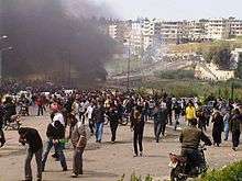
The city of Daraa played an important role by the start of the 2011 uprising against the government led by President Bashar al-Assad as part of the Arab Spring protests. According to activists, this protest was faced with Syrian security forces opening fire on the protesters killing three people.[31] Protests continued daily and on the 20th of March, 7 police men were killed as well as least 4 protesters. During this time the local courthouse, the Ba'ath party headquarters in the city, and the Syriatel building owned by Rami Makhlouf, a cousin of President Assad, were set on fire. What followed was a government assault on the city as violence continued and intensified all across Syria. In June 2011, United Nations investigators found that over 240 civilians had been killed.[32]
In February–May 2014, FSA, Islamic Front and al-Nusra Front fought the Syrian Army in southern Syria. Reportedly thousands of Western trained rebels joined the rebel forces and Gulf states promised soldiers and heavy weaponry. "Opposition websites" claimed that the rebel forces counted 30,000 fighters.
Geography
Climate
| Climate data for Dara'a | |||||||||||||
|---|---|---|---|---|---|---|---|---|---|---|---|---|---|
| Month | Jan | Feb | Mar | Apr | May | Jun | Jul | Aug | Sep | Oct | Nov | Dec | Year |
| Average high °C (°F) | 13.3 (55.9) |
14.7 (58.5) |
18.0 (64.4) |
23.6 (74.5) |
28.5 (83.3) |
31.3 (88.3) |
32.6 (90.7) |
32.6 (90.7) |
31.3 (88.3) |
27.8 (82) |
21.0 (69.8) |
15.2 (59.4) |
24.2 (75.5) |
| Average low °C (°F) | 3.2 (37.8) |
4.0 (39.2) |
6.0 (42.8) |
9.3 (48.7) |
12.5 (54.5) |
15.8 (60.4) |
18.3 (64.9) |
18.6 (65.5) |
16.5 (61.7) |
12.8 (55) |
7.8 (46) |
4.6 (40.3) |
10.8 (51.4) |
| Average precipitation mm (inches) | 60.9 (2.398) |
49.4 (1.945) |
42.3 (1.665) |
15.2 (0.598) |
3.4 (0.134) |
1.0 (0.039) |
0 (0) |
0 (0) |
0.4 (0.016) |
9.4 (0.37) |
22.9 (0.902) |
45.9 (1.807) |
250.8 (9.874) |
| Average precipitation days | 10 | 11 | 7 | 4 | 1 | 0 | 0 | 0 | 0 | 2 | 5 | 8 | 48 |
| Source: World Meteorological Organization | |||||||||||||
References
- ↑ "Syria protest town 'has new governor'". France 24. 4 April 2011. Retrieved 6 April 2011.
- 1 2 General Census of Population and Housing 2004. Syria Central Bureau of Statistics (CBS). Daraa Governorate. (Arabic)
- ↑ Source: Google Maps, accessed 24 February 2016
- ↑ Sterling, Joe. Daraa: The spark that lit the Syrian flame. CNN. 2012-03-01.
- ↑ "Three years later, south Syria's Daraa province locked in stalemate". Syria Direct. Retrieved 2016-02-17.
- ↑ "Syria: How it all began". GlobalPost. Retrieved 2016-02-17.
- ↑ "Syria: Crimes Against Humanity in Daraa". Human Rights Watch. Retrieved 2016-02-17.
- ↑ Numbers 21:33 and Deuteronomy 3:1
- 1 2 Negev, p. 150.
- ↑ William Smith, Dictionary of Greek and Roman Geography (1864): Adraa
- ↑ "Catalogue of the Greek coins in The British Museum". google.com.
- ↑ "Ancient coins of Arabia". snible.org.
- 1 2 3 4 Sharon, 2007, p. 68
- ↑ Fergus Millar, The Roman Near East, 31 B.C.-A.D. 337 (Harvard University Press 1993 ISBN 978-0-67477886-3), p. 419
- ↑ Adolf Harnack, The Mission and Expansion of Christianity in the First Three Centuries, Book 4, Chapter 3, section 1
- ↑ Albertus Frederik Johannes Klijn, G. J. Reinink, Patristic Evidence for Jewish-Christian Sects (Brill Archive 1973 ISBN 978-9-00403763-2), p. 29
- ↑ Michel Lequien, Oriens christianus in quatuor Patriarchatus digestus, Paris 1740, Vol. II, coll. 859-860
- ↑ Siméon Vailhé, v. Adraa, in Dictionnaire d'Histoire et de Géographie ecclésiastiques, vol. I, Paris 1909, coll. 592-593
- ↑ Annuario Pontificio 2013 (Libreria Editrice Vaticana 2013 ISBN 978-88-209-9070-1), p. 838
- ↑ "EDREI - JewishEncyclopedia.com". jewishencyclopedia.com.
- 1 2 3 Sharon, 2007, p. 69
- ↑ Houtma, 1993, p. 135
- ↑ le Strange, 1890, p. 34
- 1 2 3 le Strange, 1890, p. 383
- ↑ le Strange, 1890, p. 40
- 1 2 3 Sharon, 2007, p. 70
- ↑ Hütteroth and Abdulfattah, 1977, p. 214.
- ↑ Moubayed, 2006, p. 275
- ↑ Michael Gunning (26 August 2011). "Background to a Revolution". n+1.
- ↑ "Syria to free child prisoners". Al Jazeera. 20 Mar 2011. Retrieved 20 Mar 2011.
- ↑ "Middle East unrest: Three killed at protest in Syria". BBC News. 18 March 2011.
- ↑ "Killings continue in Syria as UN reaches "massacre" village". Euronews. 9 June 2012. Retrieved 9 June 2012.
Bibliography
| Wikimedia Commons has media related to Daraa. |
- Houtsma, M. H. (1993). E.J. Brill's First Encyclopaedia of Islam. 1. BRILL. ISBN 9004097961.
- Hütteroth, Wolf-Dieter; Abdulfattah, Kamal (1977). Historical Geography of Palestine, Transjordan and Southern Syria in the Late 16th Century. Erlanger Geographische Arbeiten, Sonderband 5. Erlangen, Germany: Vorstand der Fränkischen Geographischen Gesellschaft. ISBN 3-920405-41-2.
- Moubayed, Sami M. (2006). Steel and Silk. Cune Press. ISBN 9781885942401.
- Schumacher, Gottlieb (1888). Across the Jordan: being an exploration and survey of part of Hauran and Jaulan. Bentley.
- Sharon, Moshe (2007). Corpus Inscriptionum Arabicarum Palaestinae, Addendum. BRILL. ISBN 978-90-04-15780-4.
- Strange, le, Guy (1890). Palestine Under the Moslems: A Description of Syria and the Holy Land from A.D. 650 to 1500. Committee of the Palestine Exploration Fund.
Further reading
- T.E. Lawrence, (various editions) Seven Pillars of Wisdom, Chapter LXXX
External links
- Official Site of Daraa Governorate (Arabic)
- s:Encyclopaedia Biblica/Ecclesiasticus-Eglon (king)#EDREI
- Map of the town, Google Maps
- Deraa-map; 22L
Coordinates: 32°37′31″N 36°6′22″E / 32.62528°N 36.10611°E

Capital: Daraa | |||||||||||||||||||||||||||||||||||||
| |||||||||||||||||||||||||||||||||||||
| |||||||||||||||||||||||||||||||||||||
| |||||||||||||||||||||||||||||||||||||