Dependencies of Norway
Dependency |
||||
|---|---|---|---|---|
|
||||
 Dependencies of Norway
|
||||
| Largest settlements | None (several active research stations) | |||
| Languages | Norwegian | |||
| Demonym | Norwegian | |||
| Dependencies | 3 Dependencies
|
|||
| Leaders | ||||
| • | Monarch | Harald V | ||
| • | Administrators | Ministry of Justice and Public Security | ||
| Area | ||||
| • | Total | 2,700,203 km2 1,042,554 sq mi |
||
| Population | ||||
| • | estimate | Around 40 scientists | ||
| Currency | Norwegian krone | |||
| Date format | dd/mm/yyyy (AD) | |||
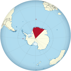
Norway has three dependent territories (Norwegian: biland), all uninhabited and located in the Southern Hemisphere. Bouvetøya is a Subantarctic island in the South Atlantic Ocean.[1] Queen Maud Land is a sector of Antarctica which spans between 20° west and 45° east.[2] Peter I Island is a volcanic island located 450 kilometres (280 mi) off the coast of Ellsworth Land of continental Antarctica.[3]
Both Peter I Island and Queen Maud Land are south of 60°S and are thus part of the Antarctic Treaty System. While the treaty states that the claims are not affected by the treaty, only the other countries with claims recognize Norwegian sovereignty on the island.[4] The dependencies are administered by the Polar Affairs Department of the Ministry of Justice and Public Security in Oslo, Norway's capital.[5] Norwegian criminal law, private law and procedural law applies to the dependencies, in addition to other laws that explicitly state they are valid on the island.[6]
Norway also has two unincorporated areas which are part of Norway, not dependencies, Jan Mayen and Svalbard.
Government and regulations
The dependency status entails that the island is not part of the Kingdom of Norway, but is still under Norwegian sovereignty. Specifically, this implies that the island can be ceded without violating the first article of the Constitution of Norway.[7] Norwegian administration of the island is handled by the Polar Affairs Department of the Ministry of Justice and the Police, located in Oslo.[5]
The annexation of the island is regulated by the Dependency Act of 24 March 1933. It establishes that Norwegian criminal law, private law and procedural law applies to the dependencies, in addition to other laws that explicitly state they are valid on each dependency. It further establishes that all land belongs to the state, and prohibits the storage and detonation of nuclear products.[8] Since 5 May 1995, Norwegian law has required all Norwegian activity in Antarctica, including Peter I Island and Queen Maud Land, to follow international environmental law for Antarctica. All Norwegian citizens who plan activities must therefore report to the Norwegian Polar Institute, who may deny any non-conforming activity. All people visiting the area must follow laws regarding protection of nature, treatment of waste, pollution and insurance for search and rescue operations.[9]
Bouvetøya has been designated with the ISO 3166-2 code BV[10] and was subsequently awarded the country code top-level domain .bv on 21 August 1997.[11]
History
- On 14 December 1911 five Norwegians, under the leadership of Roald Amundsen, were the first to reach the South Pole.
- Bouvet Island was claimed in 1927 (formally in 1930; in 1935 the island was declared a nature reserve for seals).
- Peter I Island was claimed in 1929 (formally in 1931).
- Queen Maud Land (45°E to 20°E) was formally claimed as a Norwegian possession on 14 January 1938.
- King Harald V became the first reigning monarch to visit Antarctica. He visited Queen Maud Land in 2015.
Areas
Bouvetøya
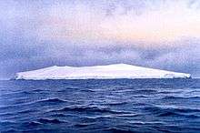
Bouvetøya is an uninhabited Subantarctic volcanic island located in the southern end of the Mid-Atlantic Ridge, either in the South Atlantic Ocean or the Southern Ocean, depending on definition.[12] It is the most remote island in the world, approximately 2,200 kilometers (1,400 mi) south-southwest off the coast of South Africa and approximately 1,700 kilometers (1,100 mi) north of the Princess Astrid Coast of Queen Maud Land, Antarctica. The island has an area of 49 square kilometres (19 sq mi), of which 93 percent is covered by a glacier. The center of the island is an ice-filled crater of an inactive volcano.[13]
Some skerries and one smaller island, Larsøya, lie along the coast.[14] Nyrøysa, created by a rock slide in the late 1950s, is the only easy place to land and is the location of a weather station.[15] Landing on the island is very difficult, as it normally experiences high seas and features a steep coast.[16] During the winter, it is surrounded by pack ice.[13] The exclusive economic zone surrounding the island covers an area of 441,163 square kilometres (170,334 sq mi).[17]
Peter I Island
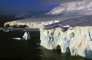
Peter I Island is a volcanic island located 450 kilometres (280 mi) off the coast of Ellsworth Land of continental Antarctica. It has an area of 154 square kilometres (59 sq mi). The island is almost entirely covered by glacier,[3] with about 95% of the surface covered by ice.[18] Surrounding the island is a 40-meter (130 ft) tall ice front and vertical cliffs.[19] The long stretches of ice caps are supplemented with rock outcrops.[18] Landing is only possible at three points, and only during the short period of the year in which the island is not surrounded by pack ice.[19] The island is a shield volcano, although it is not known if it is still active.[20] An ultra prominent peak at 1,640 metres (5,380 ft) elevation, it is named for Lars Christensen.[21] Peter I Island is the only claim within 90°W and 150°W and is also the only claim which is not a sector.[22]
Queen Maud Land
Queen Maud Land is a 2.7 million-square-kilometer (1.7 million sq mi) sector region of Antarctica.[23] The territory lies between 20° west and 45° east, between the British Antarctic Territory to the west and the Australian Antarctic Territory to the east. The latitudinal limits of the territory are not officially defined.[24] Positioned in East Antarctica, the territory comprises one-sixth of the total area of Antarctica.[25]
Most of the territory is covered by the Antarctic ice sheet, and a tall ice wall stretches throughout its coast. In some areas further within the ice sheet, mountain ranges breach through the ice, allowing for birds to breed and the growth of a limited flora. The region is divided into the Princess Martha Coast, Princess Astrid Coast, Princess Ragnhild Coast, Prince Harald Coast and Prince Olav Coast.[26] Off the coast is King Haakon VII Sea.[27] TThere is no ice-free land at the coast; the coast consists of a 20-to-30-metre-high (66 to 98 ft) wall of ice throughout almost the entire territory. [28]
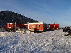
There is no permanent population, although there are 12 active research stations housing a maximum average of 40 scientists, the numbers fluctuating depending on the season. Six are occupied year-round, while the remainder are seasonal summer stations. The main aerodromes for intercontinental flights, corresponding with Cape Town, South Africa, are Troll Airfield, near the Norwegian Troll research station, and a runway at the Russian Novolazarevskaya Station.[29]
References
- ↑ "Bouvet Island". The World Factbook. Central Intelligence Agency. 11 April 2012. Retrieved 25 April 2012.
- ↑ "Dronning Maud Land" (in Norwegian). Norwegian Polar Institute. Retrieved 10 May 2011.
- 1 2 "Peter I Øy". Norwegian Climate and Pollution Agency. Archived from the original on 29 August 2011. Retrieved 29 August 2011.
- ↑ "The Antarctic Treaty". Secretariat of the Antarctic Treaty. Archived from the original on 29 August 2011. Retrieved 29 August 2011.
- 1 2 "Polar Affairs Department". Norwegian Ministry of the Environment. Archived from the original on 29 August 2011. Retrieved 29 August 2011.
- ↑ "Lov om Bouvet-øya, Peter I's øy og Dronning Maud Land m.m. (bilandsloven)" (in Norwegian). Lovdata. Archived from the original on 29 August 2011. Retrieved 29 August 2011.
- ↑ Gisle (1999): 38
- ↑ "Lov om Bouvet-øya, Peter I's øy og Dronning Maud Land m.m. (bilandsloven)" (in Norwegian). Lovdata. Archived from the original on 29 August 2011. Retrieved 29 August 2011.
- ↑ "Antarktis". Norwegian Ministry of the Environment. Archived from the original on 29 August 2011. Retrieved 29 August 2011.
- ↑ Takle, Mona Takle; Vassenden, Kåre (March 1998). "Country classifications in migration statistics – present situation and proposals for a Eurostat standard" (PDF). United Nations Statistical Commission and United Nations Economic Commission for Europe.
- ↑ "Delegation Record for .BV". Internet Assigned Numbers Authority. 13 November 2009. Archived from the original on 13 August 2010. Retrieved 5 September 2010.
- ↑ "Antarctic Convergence". Geographic Names Information System. Archived from the original on 10 May 2012. Retrieved 10 May 2012.
- 1 2 "Bouvetøya". Norwegian Polar Institute. Archived from the original on 8 May 2012. Retrieved 8 May 2012.
- ↑ "Larsøya". Norwegian Polar Institute. Archived from the original on 8 May 2012. Retrieved 8 May 2012.
- ↑ Hyser, Onno. "Bouvetøya" (PDF). BirdLife International. Archived from the original on 11 May 2012. Retrieved 11 May 2012.
- ↑ Barr (1987): 59
- ↑ "EEZ Waters Of Bouvet Isl. (Norway)". University of British Columbia. Archived from the original on 9 May 2012. Retrieved 9 May 2012.
- 1 2 Barr (1987): 65
- 1 2 "Peter I Øy". Norwegian Polar Institute. Archived from the original on 29 August 2011. Retrieved 29 August 2011.
- ↑ "Peter I Island". Global Volcanism Program. Archived from the original on 29 August 2011. Retrieved 29 August 2011.
- ↑ LeMasurier (1990): 512
- ↑ Kyvik et.al (2008): 57
- ↑ "Minifacts about Norway 2011: 2. Geography, climate and environment". Statistics Norway. 2011. Retrieved 21 August 2011.
- ↑ "Dronning Maud Land". Norwegian Polar Institute. Retrieved 20 August 2011.
- ↑ Mills (2003): 540.
- ↑ "Queen Maud Land". Encyclopædia Britannica. Retrieved 25 April 2011.
- ↑ Stonehouse: 155–156.
- ↑ "Dronning Maud Land" (in Norwegian). Norwegian Polar Institute. Retrieved 10 May 2011.
- ↑ Rubin (2008): 305.
Integral overseas areas and dependencies of Norway | ||
|---|---|---|
| Integral territories | ||
| Dependent territories | ||
| Territorial claims |  | |
|---|---|---|
| Other territories |
| |
| Former territories | ||