Delaware Route 6
| ||||
|---|---|---|---|---|
 | ||||
| Route information | ||||
| Maintained by DelDOT | ||||
| Length: | 17.31 mi[1] (27.86 km) | |||
| Existed: | 1936[2] – present | |||
| Tourist routes: |
| |||
| Major junctions | ||||
| West end: |
| |||
|
| ||||
| East end: | Delaware Avenue in Woodland Beach | |||
| Location | ||||
| Counties: | Kent | |||
| Highway system | ||||
| ||||

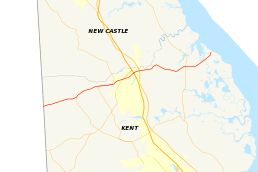
Delaware Route 6 (DE 6) is a state highway in Kent County, Delaware. It runs from Maryland Route 291 (MD 291) at the Maryland border west of Blackiston to the Delaware Bay in Woodland Beach. The route passes through rural areas of northern Kent County as well as the towns of Smyrna and Clayton. DE 6 intersects DE 42 in Blackiston, DE 15 in Clayton, DE 300 and U.S. Route 13 (US 13) in Smyrna, and DE 9 to the east of Smyrna. The road was built as a state highway during the 1920s and 1930s and received the DE 6 designation by 1936. The easternmost part of the route was paved in the 1960s and the route was moved to its current alignment bypassing downtown Smyrna by the 1990s.
Route description

DE 6 begins at the Maryland border, where the road continues west into that state as MD 291. From the state line, the route heads east on two-lane undivided Millington Road, passing through the Blackiston Wildlife Area. The road runs through areas of woods and farms with some homes. In Blackiston, DE 6 intersects the western terminus of DE 42, which heads southeast toward Kenton. The route continues east through more agricultural areas and reaches an intersection with DE 15, at which point residential development near the road increases. DE 15 turns east to form a concurrency with DE 6, with the two routes continuing east. Upon reaching the western edge of Clayton, DE 15 splits from DE 6 by heading to the north.[3][4]
DE 6 proceeds northeast through Clayton on Main Street, where it passes homes along with a few businesses. In Clayton, the road crosses Norfolk Southern's Delmarva Secondary railroad line at-grade as it turns more to the east. The route continues into Smyrna, where it becomes Smyrna Clayton Boulevard. Shortly after crossing into Smyrna, DE 6 intersects DE 300, where it turns northeast onto Glenwood Avenue and forms a concurrency with DE 300. The two routes pass a mix of homes and businesses before entering a commercial area in the northern part of Smyrna. Here, the road widens into a divided highway before intersecting US 13. At this point, DE 300 ends and DE 6 turns southeast to form a concurrency with US 13. The two routes pass more businesses on four-lane divided Dupont Boulevard. DE 6 splits from US 13 by heading to the east on two-lane undivided Commerce Street, running through residential areas. The route passes over the DE 1 toll road without an interchange and leaves Smyrna.[3][4]
Upon leaving Smyrna, DE 6 becomes Woodland Beach Road and passes to the north of Smyrna Airport. The road heads east into agricultural areas, crossing Mill Creek as it winds east. The route intersects DE 9 before turning northeast into marshland within the Woodland Beach Wildlife Area. DE 6 turns north and reaches its eastern terminus at an intersection with Delaware Avenue in the community of Woodland Beach, located along the Delaware Bay.[3][4]
The portion of the route between Alley Mill Road west of Clayton and DE 300 in Smyrna is part of the Harriet Tubman Underground Railroad Byway, a Delaware Byway.[5] DE 6 has an annual average daily traffic count ranging from a high of 21,997 vehicles at the east end of the US 13 concurrency to a low of 764 vehicles at the Lighthouse Road intersection.[1] None of DE 6 is part of the National Highway System.[6]
History
By 1920, what is now DE 6 existed as an unimproved county road.[7] The road was completed as a state highway within Clayton and was proposed as one from Clayton west to Blackiston by 1924.[8] On August 5, 1925, the state highway between Clayton and Blackiston was completed.[9] In 1929, the road leading to Woodland Beach was completed as a state highway.[10] The portion of the road between Blackiston and the Maryland border was upgraded to a state highway in 1930.[11] When Delaware created its state highway system by 1936, DE 6 was routed between the Maryland border west of Blackiston and Woodland Beach, following its current alignment to Smyrna, passing through Smyrna on Commerce Street, and continuing east on its current alignment to Woodland Beach. All of the route was paved except for the easternmost portion.[2] The eastern portion of the road was paved by 1967.[12] By the 1990s, DE 6 was routed onto its current alignment through Smyrna along DE 300 and US 13, bypassing the downtown area.[13]
Major intersections
The entire route is in Kent County.
| Location | mi[1] | km | Destinations | Notes | |
|---|---|---|---|---|---|
| Blackiston | 0.00 | 0.00 | Maryland state line, western terminus | ||
| 3.15 | 5.07 | ||||
| Clayton | West end of DE 15 overlap | ||||
| 7.08 | 11.39 | East end of DE 15 overlap | |||
| Smyrna | 7.87 | 12.67 | West end of DE 300 overlap | ||
| 8.97 | 14.44 | East end of DE 300, west end of US 13 overlap | |||
| 9.26 | 14.90 | East end of US 13 overlap | |||
| | |||||
| Woodland Beach | 17.31 | 27.86 | Delaware Avenue | Eastern terminus | |
1.000 mi = 1.609 km; 1.000 km = 0.621 mi
| |||||
See also
 U.S. Roads portal
 Delaware portal
References
- 1 2 3 Staff (2011). "Traffic Count and Mileage Report: Interstate, Delaware, and US Routes" (PDF). Delaware Department of Transportation. Retrieved May 17, 2012.
- 1 2 Delaware State Highway Department; The National Survey Co. (1936). Official Road Map of the State of Delaware (PDF) (Map) (1936–37 ed.). Dover: Delaware State Highway Department. Retrieved November 24, 2015.
- 1 2 3 Delaware Department of Transportation (2008). Delaware Official Transportation Map (PDF) (Map). Dover: Delaware Department of Transportation. Retrieved November 24, 2015.
- 1 2 3 Google (August 21, 2010). "Overview of Delaware Route 6" (Map). Google Maps. Google. Retrieved August 21, 2010.
- ↑ "Harriet Tubman Underground Railroad Byway". Delaware Department of Transportation. Retrieved January 7, 2012.
- ↑ National Highway System: Delaware (PDF) (Map). Federal Highway Administration. 2010. Retrieved February 10, 2012.
- ↑ Delaware State Highway Department (1920). Official Road Map (PDF) (Map). Dover: Delaware State Highway Department. Retrieved November 24, 2015.
- ↑ Delaware State Highway Department (1924). Official Road Map (PDF) (Map). Dover: Delaware State Highway Department. Retrieved November 24, 2015.
- ↑ "Annual Report of the State Highway Department" (PDF) (1925 ed.). Dover, Delaware: Delaware State Highway Department. December 31, 1925: 17. Retrieved November 18, 2010.
- ↑ "Annual Report of the State Highway Department" (PDF) (1929 ed.). Dover, Delaware: Delaware State Highway Department. December 31, 1929: 19. Retrieved November 15, 2014.
- ↑ "Annual Report of the State Highway Department" (PDF) (1930 ed.). Dover, Delaware: Delaware State Highway Department. December 31, 1930: 19. Retrieved November 18, 2010.
- ↑ Delaware State Highway Department (1967). Official Highway Map (PDF) (Map). Dover: Delaware State Highway Department. Retrieved November 24, 2015.
- ↑ Delaware Department of Transportation; Division of Planning Cartographic Information Section (1996). Delaware Official State Map (PDF) (Map). Dover: Delaware Department of Transportation. Retrieved November 24, 2015.
External links
 Media related to Delaware Route 6 at Wikimedia Commons