Delaware Route 286
| ||||
|---|---|---|---|---|
| Bethel Church Road | ||||
 | ||||
| Route information | ||||
| Maintained by DelDOT | ||||
| Length: | 1.73 mi[1] (2.78 km) | |||
| Existed: | 1994[2] – present | |||
| Major junctions | ||||
| West end: |
| |||
| East end: |
| |||
| Location | ||||
| Counties: | New Castle | |||
| Highway system | ||||
| ||||

Delaware Route 286 (DE 286), also known as Bethel Church Road, is a short, 1.73-mile (2.78 km) two-lane roadway in New Castle County, Delaware. The route runs from the Maryland border, where it becomes Maryland Route 286 (MD 286), east to DE 15. The route passes through rural areas with some homes. DE 286, along with MD 286 and DE 15, forms a link between Chesapeake City, Maryland and Summit Bridge, Delaware. The road was paved in the 1930s and became DE 286 in the 1990s.
Route description
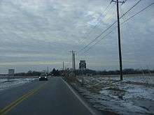
DE 286 begins at the Maryland border, where the road continues west into that state as MD 286 towards Chesapeake City, and continues east on two-lane, undivided Bethel Church Road through farmland. A short distance later, the road runs between residential developments. The road then passes between homes to the north and rural areas to the south before becoming lined with farms on both sides. DE 286 reaches its eastern terminus at DE 15, which heads south on Choptank Road and east on Bethel Church Road, at a roundabout.[3][4] DE 286 has an annual average daily traffic count of 3,519 vehicles.[1] None of DE 286 is part of the National Highway System.[5]
History
By 1920, what is now DE 286 existed as an unimproved county road.[6][7] The road in Delaware was paved by 1936 and served as part of the route between Summit Bridge and Chesapeake City.[8] Bethel Church Road from the state line east to DE 15 was designated DE 286 around 1994, extending the number from MD 286.[2]
Major intersections
The entire route is in New Castle County.
| Location | mi[1] | km | Destinations | Notes | |
|---|---|---|---|---|---|
| | 0.00 | 0.00 | Maryland state line, western terminus | ||
| Summit Bridge | 1.73 | 2.78 | Roundabout, eastern terminus | ||
| 1.000 mi = 1.609 km; 1.000 km = 0.621 mi | |||||
See also
 U.S. Roads portal
 Delaware portal
References
- 1 2 3 Staff (2011). "Traffic Count and Mileage Report: Interstate, Delaware, and US Routes" (PDF). Delaware Department of Transportation. Retrieved May 17, 2012.
- 1 2 Delaware Department of Transportation; Division of Planning Cartographic Information Section (1994). Delaware Official State Map (PDF) (Map). Dover: Delaware Department of Transportation. Retrieved November 24, 2015.
- ↑ Delaware Department of Transportation (2008). Delaware Official Transportation Map (PDF) (Map). Dover: Delaware Department of Transportation. Retrieved November 24, 2015.
- ↑ Google (July 28, 2016). "overview of Delaware Route 286" (Map). Google Maps. Google. Retrieved July 28, 2016.
- ↑ National Highway System: Delaware (PDF) (Map). Federal Highway Administration. 2012. Retrieved January 23, 2014.
- ↑ Delaware State Highway Department (1920). Official Road Map (PDF) (Map). Dover: Delaware State Highway Department. Retrieved November 24, 2015.
- ↑ Delaware State Highway Department (1924). Official Road Map (PDF) (Map). Dover: Delaware State Highway Department. Retrieved November 24, 2015.
- ↑ Delaware State Highway Department; The National Survey Co. (1936). Official Road Map of the State of Delaware (PDF) (Map) (1936–37 ed.). Dover: Delaware State Highway Department. Retrieved November 24, 2015.
External links
 Media related to Delaware Route 286 at Wikimedia Commons