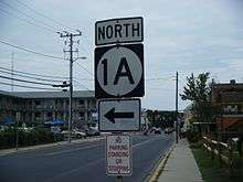
Delaware Route 1A
| |||||||
|---|---|---|---|---|---|---|---|
 | |||||||
| Route information | |||||||
| Maintained by DelDOT | |||||||
| Length: | 2.92 mi[1] (4.70 km) | ||||||
| Existed: | 1974[2] – present | ||||||
| Major junctions | |||||||
| South end: |
| ||||||
|
| |||||||
| North end: |
| ||||||
| Location | |||||||
| Counties: | Sussex | ||||||
| Highway system | |||||||
| |||||||

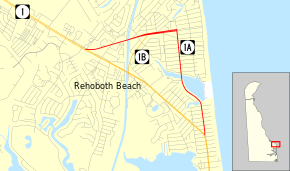
Delaware Route 1A (DE 1A) is a state highway in Sussex County, Delaware. The route runs 2.92 mi (4.70 km) from DE 1 in Dewey Beach to another intersection with DE 1 west of Rehoboth Beach. The route provides access to Rehoboth Beach from DE 1, heading north before turning to the west. DE 1A follows King Charles Avenue, Bayard Avenue, 2nd Street (southbound), Christian Street (northbound), and Rehoboth Avenue.
What is now DE 1A was originally a part of DE 14 between 1936 and 1942. The road was designated DE 14A by 1966. In the 1970s, DE 1A was designated along DE 14A for a few years before DE 14A was decommissioned in favor of DE 1A. Between 2002 and 2006, a streetscape project revitalized the Rehoboth Avenue portion of the route and a roundabout was added at the entrance to Rehoboth Beach.
Route description
DE 1A begins at an intersection with DE 1 in Dewey Beach, heading north on two-lane undivided King Charles Avenue. The road passes through residential areas before it curves northwest and runs to the south of Silver Lake. The route bends north and crosses the lake, where it enters Rehoboth Beach. Here, the name changes to Bayard Avenue and it becomes a divided highway. DE 1A becomes undivided again and comes to an intersection with Christian Street. At this point, northbound DE 1A turns northwest onto Christian Street to reach Rehoboth Avenue while southbound DE 1A follows 2nd Street north to Rehoboth Avenue.[3][4]
The highway heads west along four-lane divided Rehoboth Avenue and passes businesses. The road intersects DE 1B before it comes to a roundabout at Grove Street/Columbia Avenue. Following this, the route narrows into a two-lane undivided road and crosses the Lewes and Rehoboth Canal on a drawbridge, leaving Rehoboth Beach. DE 1A continues west past homes and businesses and ends at another intersection with DE 1.[3][4]
DE 1A has an annual average daily traffic count ranging from a high of 21,215 vehicles just west of Rehoboth Beach to a low of 3,076 vehicles on the service road at the northern terminus at DE 1.[1] None of DE 1A is part of the National Highway System.[5]
History
| |
|---|---|
| Location: | Dewey Beach-Rehoboth Beach |
| Length: | 2.92 mi[1] (4.70 km) |
| Existed: | 1966[6]–1977[7] |
What is now DE 1A was originally designated as part of DE 14 by 1936.[8] By 1942, DE 14 was realigned to bypass Rehoboth Beach to the southwest.[9] DE 14A was designated onto the former alignment of DE 14 through Rehoboth Beach by 1966.[6] By 1974, DE 14A became concurrent with DE 1A.[2] The DE 14A designation was dropped in 1977 and the road was solely designated DE 1A.[7]
In October 2002, work began on a streetscape project to revitalize Rehoboth Avenue.[10] The project provided new sidewalks and plants and placed utility lines underground.[11] A roundabout opened at Grove Street and Columbia Avenue in May 2004.[12] The roundabout features a replica of the Cape Henlopen Light and serves as a gateway to Rehoboth Beach.[13] When the roundabout first opened, there were issues of drivers not yielding properly.[12] As a result, improved yield signage was installed.[14] The streetscape project was completed in June 2006, with a ribbon cutting held. The project cost $36 million; DelDOT paid $16.3 million, the city of Rehoboth Beach provided $10 million, and the Federal Highway Administration provided $7.75 million. U.S. Senators Tom Carper and Joe Biden helped secure federal funds for the project.[11]
Major intersections
The entire route is in Sussex County.
| Location | mi[1] | km | Destinations | Notes | |
|---|---|---|---|---|---|
| Dewey Beach | 0.00 | 0.00 | Southern terminus | ||
| Rehoboth Beach | |||||
| 2.92 | 4.70 | Northern terminus | |||
| 1.000 mi = 1.609 km; 1.000 km = 0.621 mi | |||||
See also
 U.S. Roads portal
 Delaware portal
References
- 1 2 3 4 Staff (2011). "Traffic Count and Mileage Report: Interstate, Delaware, and US Routes" (PDF). Delaware Department of Transportation. Retrieved May 17, 2012.
- 1 2 Maryland State Highway Administration (1974). Maryland: Official Highway Map (Map). Baltimore: Maryland State Highway Administration.
- 1 2 Delaware Department of Transportation (2008). Delaware Official Transportation Map (PDF) (Map). Dover: Delaware Department of Transportation. Retrieved November 24, 2015.
- 1 2 Google (February 6, 2013). "overview of Delaware Route 1A" (Map). Google Maps. Google. Retrieved February 6, 2013.
- ↑ National Highway System: Delaware (PDF) (Map). Federal Highway Administration. 2010. Retrieved February 10, 2012.
- 1 2 Delaware State Highway Department (1966). Official Highway Map (PDF) (Map). Dover: Delaware State Highway Department. Retrieved November 24, 2015.
- 1 2 Maryland State Highway Administration (1977). Maryland: Official Highway Map (Map). Baltimore: Maryland State Highway Administration.
- ↑ Delaware State Highway Department; The National Survey Co. (1936). Official Road Map of the State of Delaware (PDF) (Map) (1936–37 ed.). Dover: Delaware State Highway Department. Retrieved November 24, 2015.
- ↑ Delaware State Highway Department (1942). Official Road Map of the State of Delaware (PDF) (Map). Dover: Delaware State Highway Department. Retrieved November 24, 2015.
- ↑ "City of Rehoboth Beach Wastewater Treatment Plant Ocean Outfall Project Environmental Impact Statement" (PDF). Delaware Department of Natural Resources and Environmental Control. March 2012. Retrieved February 6, 2013.
- 1 2 Spence, Kevin (June 22, 2006). "Rehoboth celebrates completion of Streetscape". Cape Gazette. p. 4. Retrieved February 6, 2013.
- 1 2 Lytle, Tara (June 11, 2004). "Roundabout gets a round of criticism". Cape Gazette. p. 1. Retrieved February 6, 2013.
- ↑ "Ribbon Cutting Ceremony Celebrates the Completion of the Rehoboth Avenue Streetscape Project". Delaware Department of Transportation. June 16, 2006. Retrieved February 6, 2013.
- ↑ "Yield sign makes roundabout easier for Rehoboth drivers". Cape Gazette. June 25, 2004. p. 9. Retrieved February 6, 2013.
External links
 Media related to Delaware Route 1A at Wikimedia Commons