Deir ez-Zor District
| Deir ez-Zor District منطقة دير الزور | |
|---|---|
| District | |
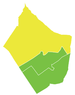 Map of Deir ez-Zor District within Deir ez-Zor Governorate | |
| Coordinates (Deir ez-Zor): 35°20′N 40°09′E / 35.33°N 40.15°ECoordinates: 35°20′N 40°09′E / 35.33°N 40.15°E | |
| Country |
|
| Governorate | Deir ez-Zor |
| Seat | Deir ez-Zor |
| Subdistricts | 7 nawāḥī |
| Area | |
| • Total | 14,389.60 km2 (5,555.86 sq mi) |
| Population (2004)[1] | |
| • Total | 492,434 |
| • Density | 34/km2 (89/sq mi) |
| Geocode | SY0901 |
Deir ez-Zor District (Arabic: منطقة دير الزور, translit. manṭiqat Dair az-Zaur) is a district of the Deir ez-Zor Governorate in Northeastern Syria. Administrative centre is the city of Deir ez-Zor. At the 2004 census, the district had a population of 492,434.[1]

The administrative center of Nahiya Kasrah shown above is the city of al-Kasrah.

The administrative center of Nahiya al-Tibni shown above is the city of al-Al-Tibni.
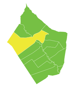
The administrative center of Nahiya Deir ez-Zor shown above is the city of Deir ez-Zor.

The administrative center of Nahiya Sur shown above is the city of Al-Sur.

The administrative center of Nahiya al-Busayrah shown above is the city of Al-Busayrah.

The administrative center of Nahiya Khesham shown above is the city of Khesham.

The administrative center of Nahiya Muhasan shown above is the city of Muhasan.
Sub-districts
The district of Deir ez-Zor is divided into seven sub-districts or nawāḥī (population as of 2004[1]):
- Deir ez-Zor Nahiyah (ناحية دير الزور): population 239,196.[2]
- Al-Kasrah Nahiyah (ناحية الكسرة): population 63,226.[3]
- Al-Busayrah Nahiyah (ناحية البصيرة): population 40,236.[4]
- Al-Muhasan Nahiyah (ناحية الموحسن): population 35,113.[5]
- Al-Tabni Nahiyah (ناحيةالتبني): population 48,393.[6]
- Khasham Nahiyah (ناحية خشام): population 28,718.[7]
- Al-Sur Nahiyah (ناحية الصور): population 37,552.[8]
References
- 1 2 3 "2004 Census Data". UN OCHA. Retrieved 15 October 2015.
- ↑ "Deir ez-Zor nahiyah population". Cbssyr.org. Retrieved 2012-06-18.
- ↑ "Kasra nahiyah population". Cbssyr.org. Retrieved 2012-06-18.
- ↑ "Busayrah nahiyah population". Cbssyr.org. Retrieved 2012-06-18.
- ↑ "Muhasan nahiyah population". Cbssyr.org. Retrieved 2012-06-18.
- ↑ "Al-Tibni nahiyah population". Cbssyr.org. Retrieved 2012-06-18.
- ↑ "Khesham nahiyah population". Cbssyr.org. Retrieved 2012-06-18.
- ↑ "Sour nahiyah population". Cbssyr.org. Retrieved 2012-06-18.
This article is issued from Wikipedia - version of the 10/22/2016. The text is available under the Creative Commons Attribution/Share Alike but additional terms may apply for the media files.