De Waterkant
| De Waterkant | |
|---|---|
 | |
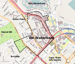 Street map of De Waterkant | |
 De Waterkant  De Waterkant  De Waterkant
| |
|
Location within Cape Town  De Waterkant | |
| Coordinates: 33°54′55″S 18°25′08″E / 33.91528°S 18.41889°ECoordinates: 33°54′55″S 18°25′08″E / 33.91528°S 18.41889°E | |
| Country | South Africa |
| Province | Western Cape |
| Municipality | City of Cape Town |
| Area[1] | |
| • Total | 0.30 km2 (0.12 sq mi) |
| Population (2011)[1] | |
| • Total | 361 |
| • Density | 1,200/km2 (3,100/sq mi) |
| Racial makeup (2011)[1] | |
| • Black African | 11.6% |
| • Coloured | 5.0% |
| • Indian/Asian | 5.5% |
| • White | 75.3% |
| • Other | 2.5% |
| First languages (2011)[1] | |
| • English | 69.8% |
| • Afrikaans | 17.2% |
| • Sotho | 1.4% |
| • Other | 11.6% |
| Postal code (street) | 8001 |
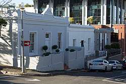
De Waterkant is a sub-district of the suburb of Green Point, Cape Town. The neighbourhood is adjacent to the Central Business District on the southeastern end of Somerset Road. From south, it is neighboured by the historically coloured district of Bo-Kaap.
De Waterkant is typically a sought-after address for young professionals, the upper-class gay and lesbian community, and niche restaurants and retailers. The area is home to the Cape Quarter shopping mall[2] and Vega's Cape Town campus.[3]
References
- 1 2 3 4 "Sub Place De Waterkant". Census 2011.
- ↑ "Contact Us". Cape Quarter. Retrieved 2016-02-08.
- ↑ "Vega Campuses". Vega. Retrieved 2016-02-08.
Further reading
- Rink, Bradley Michael (2008). Village People: Quartering De Waterkant in discourse and bricks (Ph.D. thesis). University of Cape Town. Retrieved 30 June 2014.
| Wikimedia Commons has media related to De Waterkant. |
.svg.png)
| Law |
| .svg.png) | ||||||||||||||
|---|---|---|---|---|---|---|---|---|---|---|---|---|---|---|---|---|
| People | ||||||||||||||||
| Organisations | ||||||||||||||||
| Languages | ||||||||||||||||
| Gay villages | ||||||||||||||||
| Events | ||||||||||||||||
| Media | ||||||||||||||||
| Issues | ||||||||||||||||
| Other | ||||||||||||||||
Category:LGBT in South Africa | ||||||||||||||||
This article is issued from Wikipedia - version of the 2/8/2016. The text is available under the Creative Commons Attribution/Share Alike but additional terms may apply for the media files.