Dargeçit
| Dargeçit | |
|---|---|
 Dargeçit | |
| Coordinates: 37°32′45″N 41°43′28″E / 37.54583°N 41.72444°ECoordinates: 37°32′45″N 41°43′28″E / 37.54583°N 41.72444°E | |
| Country |
|
| Province | Mardin |
| Government | |
| • Mayor | Zeynep Sipçik (BDP) |
| • Kaymakam | Adem Ünal |
| Area[1] | |
| • District | 538.94 km2 (208.09 sq mi) |
| Elevation | 940 m (3,080 ft) |
| Population (2012)[2] | |
| • Urban | 17,329 |
| • District | 30,253 |
| • District density | 56/km2 (150/sq mi) |
| Post code | 47750 |
| Website |
www |

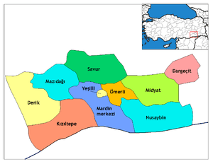
Dargeçit (Syriac: ܟܪܒܘܪܢ Kerburan, Kurdish:Kerboran) is a district of the Mardin Province of Turkey, traditionally populated by ethnic-Kurds. In 1900, the town had approximately 300 families. Prior to the Assyrian and Armenian Genocides this city was inhabited by Kurds, Assyrians/Syriacs and Armenians. Before 1979, it was still inhabited by Kurds and Assyrians, but most of the Assyrian/Syriac people fled/left the city after the murder of Andreas Demir Lahdik, the Mayor of Kerburan at the time. The government then changed the name of the city to Dargeçit by force. After the exodus, the town was nearly completely populated by a Kurdish majority, with a tiny Assyrian remnant.
There is the Syriac Orthodox Church of Mor Kuriyakos, which is now restored thanks to the Assyrian/Syriac diaspora. There are also two other churches, one Protestant and the other Catholic. They are both abandoned.
References
- ↑ "Area of regions (including lakes), km²". Regional Statistics Database. Turkish Statistical Institute. 2002. Retrieved 2013-03-05.
- ↑ "Population of province/district centers and towns/villages by districts - 2012". Address Based Population Registration System (ABPRS) Database. Turkish Statistical Institute. Retrieved 2013-02-27.