Darayya District
| Darayya District منطقة داريا | |
|---|---|
| District | |
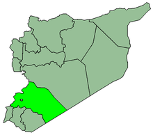
 Map of Darayya District within Rif Dimashq Governorate | |
| Coordinates (Qatana): 33°27′N 36°15′E / 33.45°N 36.25°ECoordinates: 33°27′N 36°15′E / 33.45°N 36.25°E | |
| Country |
|
| Governorate | Rif Dimashq |
| Seat | Darayya |
| Subdistricts | 3 nawāḥī |
| Area | |
| • Total | 102.48 km2 (39.57 sq mi) |
| Population (2004)[1] | |
| • Total | 260,961 |
| • Density | 2,500/km2 (6,600/sq mi) |
| Geocode | SY0309 |
Darayya District (Arabic: منطقة داريا, translit. manṭiqat Dārayyā) is a district of the Rif Dimashq Governorate in southern Syria. Administrative centre is the city of Darayya. At the 2004 census, the district had a population of 260,961.[1]
Sub-districts
The district of Darayya is divided into three sub-districts or nawāḥī (population as of 2004[1]):
| Code | Name | Area | Population |
|---|---|---|---|
| SY030900 | Darayya nahiyah | 53.60 km² | 131,501 |
| SY030901 | Sahnaya nahiyah | 43.53 km² | 44,512 |
| SY030902 | al-Hajar al-Aswad nahiyah | 5.36 km² | 84,948 |
Localities in Darayya District
According to the Central Bureau of Statistics (CBS), the following villages, towns and cities make up the district of Darayya:[1]
| English Name | Arabic Name | Population | Subdistrict |
|---|---|---|---|
| al-Hajar al-Aswad | الحجر الأسود | 84,948 | Al-Hajar al-Aswad |
| Darayya | داريا | 78,763 | Darayya |
| Muadamiyat al-Sham | معضمية الشام | 52,738 | Darayya |
| Ashrafiyat Sahnaya | أشرفية صحنايا | 30,519 | Sahnaya |
| Sahnaya | صحنايا | 13,993 | Sahnaya |
References
- 1 2 3 4 "2004 Census Data" (PDF) (in Arabic). Syrian Central Bureau of Statistics. Retrieved 15 October 2015.
Also available in English: "2004 Census Data". UN OCHA. Retrieved 15 October 2015.
This article is issued from Wikipedia - version of the 10/21/2015. The text is available under the Creative Commons Attribution/Share Alike but additional terms may apply for the media files.