Danes Island
Danes Island[1][2][3] (Norwegian: Danskøya) is an island in Norway's Svalbard archipelago in the Arctic Ocean. It lies just off the northwest coast of Spitsbergen, the largest island in the archipelago, near to Magdalenefjorden.[4] Just to the north lies Amsterdam Island. Like many of Svalbard's islands, Danes Island is uninhabited.[5] The island has an area of 40.6 km2 (15.7 sq mi).[6]
History
In 1631 the Danish established a permanent station in Robbe Bay (Kobbefjorden), which was abandoned in 1658.[7] Another station was established by the Dutch in Houcker Bay (Virgohamna), on the north side of Danes Island in the 1630s. It was called the "Cookery of Harlingen." The remains of this station were seen by Friderich Martens in 1671.[8]
The island is the location from which S. A. Andrée's Arctic balloon expedition of 1897 started. Andrée's hydrogen balloon crashed on the pack ice three days after its launch from Danes Island, and after wandering and drifting for nearly three months, the explorers finally perished on Kvitøya, also in Svalbard.[9]
Gallery
-
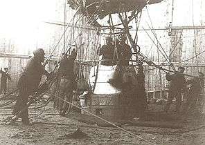
S. A. Andrée's balloon before takeoff on July 11, 1897.
-

Whaling on Danes Island, by Abraham Speech, 1634. Skokloster Castle.
-
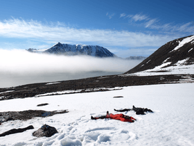
Making snow-angels on Danes Island on July 19, 2008.
-

17th century Dutch map of "Deense Eyland".
See also
Citations
- ↑ Mills, William James. 2003. Exploring Polar Frontiers: A Historical Encyclopedia. Volume 1: A–L. Santa Barbara, CA: ABC Clio, p. 171.
- ↑ National Geospatial-Intelligence Agency: Geographical Names.
- ↑ Peter Joseph Capelotti. 1999. By Airship to the North Pole: An Archaeology of Human Exploration. New Brunswick, NJ: Rutgers University Press, pp. xii ff.
- ↑ Location information from Spitsbergen North. Svalbard-images.com (URL accessed 24 July 2006)
- ↑ Only three of the islands (Spitsbergen, Bjørnøya and Hopen) have settlements. Svalbard: General, Norwegian Polar Institute. Last updated 27 May 2004. (URL accessed 24 July 2006)
- ↑ Norwegian Polar Institute Place names in Norwegian polar areas
- ↑ Dalgård, Sune (1962). Dansk-Norsk Hvalfangst 1615–1660: En Studie over Danmark-Norges Stilling i Europæisk Merkantil Expansion. G.E.C Gads Forlag.
- ↑ Conway, W. M. 1906. No Man's Land: A History of Spitsbergen from Its Discovery in 1596 to the Beginning of the Scientific Exploration of the Country. Cambridge: At the University Press.
- ↑ Lundström, Sven (1997), pp. 73–114
References
- Lundström, Sven (1997). "Vår position är ej synnerligen god…" Andréexpeditionen i svart och vitt. Borås: Carlssons förlag. (Swedish)
Coordinates: 79°40′N 10°54′E / 79.667°N 10.900°E