Damour river
| Damour river | |
|---|---|
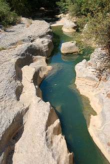 The Damour river at Jisr el Qadi | |
| Country | Lebanon |
| Basin | |
| Main source |
Nabaa Al Safa, Nabeh Al Barouk 1,950 m (6,400 ft) |
| River mouth |
Mediterranean Sea 33°42′21″N 35°26′22″E / 33.70583°N 35.43944°ECoordinates: 33°42′21″N 35°26′22″E / 33.70583°N 35.43944°E |
| Physical characteristics | |
| Length | 37.5 km (23.3 mi) |
| Discharge |
|
Damour river or (Arabic: نهر الدامور, Nahr Al Damour) is a 37.5-kilometre (23.3 mi) coastal river in the Mount Lebanon Governorate in Lebanon. The headwaters of the river is Barouk mount. It flows west through Jisr Al kadi valley, then receives the chouf mountains creeks. The river flows towards the Mediterranean sea, south of Damour, the largest town on its banks and which bears the name of the river.
Mythology
During the Phoenician time, Canaanite people being affected by drought seasons, called the river "Damoros" ancient Tamyrus,[2] in attribution of 'Damoros' god of immortality, related to 'Achtarout', god of love and beauty. This attribution symbolised the immortality of the river 'Arabic: النهر الدامر' and the beauty of the region. In 1302, the river being a strategic point towards the holy land, a crusade battle took place on its edge. Following the battle, French crusaders nicknamed the river "Fleuve D'amour".
The city foundation
The city was founded on the river's edge by poor people who wanted to charge the right of way to the emirs. Because the river have big flow rate in the winter season, residents assured the transport of passengers from side to other, obliging passengers to pay dearly for this service.
References
- ↑ Lebanese coastal rivers, Damour: 307 000 m3/year
- ↑ Travels in Palestine and Syria, Volume 1, page 286 By George Robinson