Dalzell, South Carolina
| Dalzell, South Carolina | |
|---|---|
| CDP | |
| Nickname(s): Razzle Dazzle | |
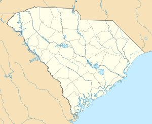 Dalzell, South Carolina Location within the state of South Carolina | |
| Coordinates: 34°1′11″N 80°25′47″W / 34.01972°N 80.42972°WCoordinates: 34°1′11″N 80°25′47″W / 34.01972°N 80.42972°W | |
| Country | United States |
| State | South Carolina |
| County | Sumter |
| Area | |
| • Total | 6.9 sq mi (17.9 km2) |
| • Land | 6.9 sq mi (17.8 km2) |
| • Water | 0.0 sq mi (0.1 km2) |
| Elevation | 217 ft (66 m) |
| Population (2000) | |
| • Total | 2,260 |
| • Density | 329.7/sq mi (127.3/km2) |
| Time zone | Eastern (EST) (UTC-5) |
| • Summer (DST) | EDT (UTC-4) |
| ZIP code | 29040 |
| Area code(s) | 803 |
| FIPS code | 45-18430[1] |
| GNIS feature ID | 1221916[2] |
Dalzell is a census-designated place (CDP) in Sumter County, South Carolina, United States. The population was 2,260 at the 2000 census. It is included in the Sumter, South Carolina Metropolitan Statistical Area.
History
Orange Grove and St. Philip's Episcopal Church, Bradford Springs are listed on the National Register of Historic Places.[3]
Geography
Dalzell is located at 34°1′11″N 80°25′47″W / 34.01972°N 80.42972°W (34.019811, -80.429780).[4]
According to the United States Census Bureau, the CDP has a total area of 6.9 square miles (18 km2), of which, 6.8 square miles (18 km2) of it is land and 0.1 square miles (0.26 km2) of it (0.72%) is water.
Demographics
As of the census[1] of 2000, there were 2,260 people, 805 households, and 622 families residing in the CDP. The population density was 329.7 people per square mile (127.4/km²). There were 895 housing units at an average density of 130.6/sq mi (50.4/km²). The racial makeup of the CDP was 61.11% Caucasian, 33.98% African American, 0.53% Native American, 1.11% Asian, 0.04% Pacific Islander, 1.46% from other races, and 1.77% from two or more races. Hispanic or Latino of any race were 3.27% of the population.
There were 805 households out of which 45.1% had children under the age of 18 living with them, 56.0% were married couples living together, 16.4% had a female householder with no husband present, and 22.7% were non-families. 19.1% of all households were made up of individuals and 5.1% had someone living alone who was 65 years of age or older. The average household size was 2.81 and the average family size was 3.20.
In the CDP the population was spread out with 32.5% under the age of 18, 8.9% from 18 to 24, 34.5% from 25 to 44, 17.7% from 45 to 64, and 6.5% who were 65 years of age or older. The median age was 30 years. For every 100 females there were 94.8 males. For every 100 females age 18 and over, there were 91.9 males.
The median income for a household in the CDP was $40,750, and the median income for a family was $41,979. Males had a median income of $29,006 versus $22,000 for females. The per capita income for the CDP was $15,124. About 12.0% of families and 14.9% of the population were below the poverty line, including 24.3% of those under age 18 and 4.0% of those age 65 or over.[5]
Notable residents
- Bill Pinkney - American singer and original member of The Drifters most known for his rendition of "White Christmas."
- Ray Allen- NBA player of Miami Heat and NBA-champion in 2008 with the Boston Celtics. On February 10, 2011 he became the NBA's all-time leader in three-point field goals, passing Reggie Miller.
References
- 1 2 "American FactFinder". United States Census Bureau. Archived from the original on September 11, 2013. Retrieved 2008-01-31.
- ↑ "US Board on Geographic Names". United States Geological Survey. 2007-10-25. Retrieved 2008-01-31.
- ↑ National Park Service (2010-07-09). "National Register Information System". National Register of Historic Places. National Park Service.
- ↑ "US Gazetteer files: 2010, 2000, and 1990". United States Census Bureau. 2011-02-12. Retrieved 2011-04-23.
- ↑ US Census Bureau Data
External links
Municipalities and communities of Sumter County, South Carolina, United States | ||
|---|---|---|
| City | 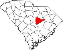 | |
| Towns | ||
| CDPs | ||
| Unincorporated communities | ||