Dale, Hordaland
| Dale Dalekvam | |
|---|---|
| Village | |
|
View of the village | |
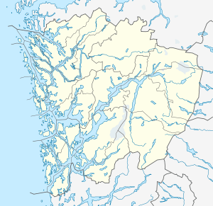 Dale  Dale Location in Hordaland county | |
| Coordinates: 60°35′11″N 05°49′07″E / 60.58639°N 5.81861°ECoordinates: 60°35′11″N 05°49′07″E / 60.58639°N 5.81861°E | |
| Country | Norway |
| Region | Western Norway |
| County | Hordaland |
| District | Nordhordland |
| Municipality | Vaksdal |
| Area[1] | |
| • Total | 0.72 km2 (0.28 sq mi) |
| Elevation[2] | 36 m (118 ft) |
| Population (2013)[1] | |
| • Total | 1,163 |
| • Density | 1,615/km2 (4,180/sq mi) |
| Time zone | CET (UTC+01:00) |
| • Summer (DST) | CEST (UTC+02:00) |
| Post Code | 5722 Dalekvam |

Dale or Dalekvam is the administrative centre of Vaksdal municipality, in Hordaland county, Norway. The village lies at the western end of the Bergsdalen valley, about 5 kilometres (3.1 mi) northeast of the village of Stanghelle on the shore of the Veafjorden. The village lies along the European route E16, the Bergensbanen railway line (and Dale Station), and the river Daleelva. The 0.72-square-kilometre (180-acre) urban area of Dale has a population (2013) of 1,163; giving the village area a population density of 1,615 inhabitants per square kilometre (4,180/sq mi).[1] The small Dalegarden village at the southern end of Dale is included in the "urban area" of Dale.

Dale Church is located in the village. The village is also the site of the international Dale of Norway company which manufactures wool sweaters and outdoor jackets. There is also a textile mill and other small industries.[3]
References
- 1 2 3 Statistisk sentralbyrå (1 January 2013). "Urban settlements. Population and area, by municipality.".
- ↑ "Dale, Vaksdal" (in Norwegian). yr.no. Retrieved 2014-05-02.
- ↑ Store norske leksikon. "Dale – tettsted i Vaksdal" (in Norwegian). Retrieved 2014-05-02.