Dagupan
| Dagupan City | ||
|---|---|---|
| Independent Component City | ||
| City of Dagupan | ||
|
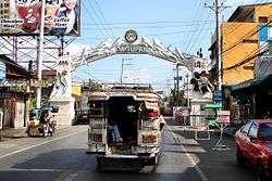
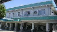
Welcome arch | ||
| ||
| Nickname(s): Milk Fish Capital of the Philippines; The "Melting Pot" of Pangasinan | ||
 Location in Pangasinan | ||
.svg.png) Dagupan Location within the Philippines | ||
| Coordinates: 16°02′N 120°20′E / 16.03°N 120.33°ECoordinates: 16°02′N 120°20′E / 16.03°N 120.33°E | ||
| Country | Philippines | |
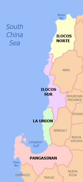
| Region | Ilocos (Region I) | |
| Province | Pangasinan (geographically only) | |
| District | 4th district of Pangasinan | |
| Founded | 1590 | |
| Cityhood | June 20, 1947 | |
| Barangays | 31 | |
| Government[1] | ||
| • Mayor | Belen T. Fernandez | |
| Area[2] | ||
| • Total | 37.23 km2 (14.37 sq mi) | |
| Population (2015)[3] | ||
| • Total | 171,271 | |
| • Density | 4,600/km2 (12,000/sq mi) | |
| Demonym(s) | Dagupeño (masculine)/Dagupeña (feminine) | |
| Time zone | PST (UTC+8) | |
| ZIP code | 2400 | |
| Dialing code | 75 | |
| Income class | 2nd class[4][5] | |
| Website |
dagupan | |
Dagupan, officially the City of Dagupan (Pangasinan: Siyudad na Dagupan; Filipino: Lungsod ng Dagupan) or simply Dagupan City, is an independent component city in the province of Pangasinan in the Philippines. According to the census of 2015, Dagupan City has a population of 171,271 people with an income classification of second class.[4][5]
Located on the Lingayen Gulf on the island of Luzon, Dagupan is a major commercial and financial center north of Manila. Also, the city is one of the centers of modern medical services, media and communication in Northern Luzon. Dagupan is situated within the fertile Agno River Valley.
The city is among the top producers of bangus/milkfish in the province. From 2001-2003, Dagupan's milkfish production totaled to 35,560.1 metric tons (MT), contributing 16.8 percent to the total provincial production. Of its total production in the past three years, 78.5 percent grew in fish pens/cages while the rest grew in brackish water fishpond.[6]
Etymology
The city's name was derived from the local Pangasinense word pandaragupan, meaning "gathering place" as the city has been a regional market center for centuries.
History
Huangdom of Pangasinan
During the 15th century, Pangasinan had been the site of an ancient kingdom called the Huangdom of Pangasinan (Known as Feng-chia-hsi-lan in Chinese records). A succession of local kings starting from Huang Kamayin set the kingdom up as a trade-center exporting silver, horses and Torquise shells to the ports in Japan, Ryukyu and China which in turn, sold silks and samurai swords to the Kingdom of Pangasinan.[7]
Spanish occupation
The area that is now known as Dagupan was described as marshland thickly covered with mangrove and nipa palm trees.[8] The natives lived along the shoreline and riverbanks of Calmay, Pantal, and Bonuan. But there were also communities in Malued, Lasip, Pogo, and Bacayao. The natives called the area Bacnotan which would later be incorporated into the encomienda of Lingayen that was established in 1583.
Japanese Occupation
The Japanese planes bombed in Dagupan on December 1941 and through the occupying the Japanese forces on 1942. [9]
Allied liberation
On January 8–January 9, 1945, U.S. General Douglas MacArthur landed his amphibious liberation force in the city's "Blue Beach" section along the Lingayen Gulf. From his beachhead in Dagupan, along with those in neighboring towns Lingayen, Binmaley and San Fabian, MacArthur's forces under General Walter Krueger together with the Philippine Commonwealth troops under the Philippine Army and Philippine Constabulary units were able to penetrate Japanese defenses in Luzon island and liberate Filipino and allied prisoners of war near Cabanatuan in the province of Nueva Ecija, and in Manila's University of Sto. Tomas, among others.
Dagupan's cityhood

Dagupan became a city by virtue of Republic Act No. 170, authored by Speaker Eugenio Pérez. It was signed into law by President Manuel Roxas on June 20, 1947.[10]
The westward expansion of the city went as far as Lucao, which was also swampland. Local historian Restituto Basa surmised that the name Lucao may have been derived from the shellfish called lukan that used to abound in the swampy area.
In June 1962, Dagupan was shaken by a series of strong earthquakes which occurred at irregular intervals for about three weeks. The quakes toppled the belfry of the Roman Catholic Church. Many people from Calmay, Carael and island barrios evacuated to other towns.
In 1968, the national government agencies opened offices in Dagupan and other key cities across the country. The daytime population increased substantially, causing congestion in the city that began to see the appearance of public utility tricycles.
On July 16, 1990, a magnitude 7.7 earthquake struck northern Luzon, causing liquefaction, which made buildings tilt and sink due to their heavy weight and the looseness of the ground, which turned into sediment-rich mud. One of the two bridges, especially Magsaysay Bridge spanning the Pantal River, collapsed, delaying people from crossing to the other banks and vice versa. Major damage caused businesses to be permanently transferred to the neighbouring towns of Mangaldan and Calasiao, but somehow, Dagupan and its inhabitants managed to recover from the earthquake.[11]
Geography
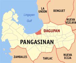
Dagupan City covers a total land area of 3,723 hectares (9,200 acres),[2] bounded by the Lingayen Gulf in the north, San Fabian in the northeast, Mangaldan in the east, Calasiao in the south and Binmaley in the west. Land use is primarily for agriculture with 35.98% of the total land area, fishpond, cropland, residential with 22.88%; others uses are commercial, industrial, institutional, government private, parks, and roads.

Barangays
Dagupan City is politically subdivided into 31 barangays.[4]
|
|

Climate
| Climate data for Dagupan City | |||||||||||||
|---|---|---|---|---|---|---|---|---|---|---|---|---|---|
| Month | Jan | Feb | Mar | Apr | May | Jun | Jul | Aug | Sep | Oct | Nov | Dec | Year |
| Record high °C (°F) | 37 (99) |
37 (99) |
38 (100) |
39 (102) |
42 (108) |
38 (100) |
38 (100) |
38 (100) |
40 (104) |
42 (108) |
34 (93) |
37 (99) |
42 (108) |
| Average high °C (°F) | 30 (86) |
30 (86) |
32 (90) |
33 (91) |
33 (91) |
31 (88) |
31 (88) |
30 (86) |
31 (88) |
31 (88) |
30 (86) |
30 (86) |
31 (87.8) |
| Daily mean °C (°F) | 26 (79) |
26 (79) |
28 (82) |
29 (84) |
29 (84) |
28 (82) |
28 (82) |
27 (81) |
28 (82) |
28 (82) |
27 (81) |
26 (79) |
27.5 (81.4) |
| Average low °C (°F) | 22 (72) |
22 (72) |
23 (73) |
25 (77) |
26 (79) |
25 (77) |
25 (77) |
25 (77) |
25 (77) |
25 (77) |
24 (75) |
22 (72) |
24.1 (75.4) |
| Record low °C (°F) | 13 (55) |
18 (64) |
18 (64) |
17 (63) |
18 (64) |
16 (61) |
22 (72) |
17 (63) |
10 (50) |
20 (68) |
11 (52) |
16 (61) |
10 (50) |
| Average rainfall mm (inches) | 4.3 (0.169) |
19.1 (0.752) |
27.3 (1.075) |
45.2 (1.78) |
153.3 (6.035) |
271.3 (10.681) |
411.1 (16.185) |
532.0 (20.945) |
364.4 (14.346) |
182.5 (7.185) |
56.3 (2.217) |
24.4 (0.961) |
2,091.2 (82.331) |
| Average rainy days | 3 | 2 | 3 | 5 | 14 | 17 | 22 | 23 | 21 | 13 | 7 | 4 | 134 |
| Average relative humidity (%) | 85 | 84 | 84 | 84 | 88 | 91 | 92 | 94 | 93 | 92 | 89 | 86 | 88.5 |
| Mean daily sunshine hours | 11.7 | 12 | 12.4 | 12.9 | 13.3 | 13.5 | 13.4 | 13.0 | 12.6 | 12.1 | 11.8 | 11.6 | 12.52 |
| Source #1: World Weather Online[14] | |||||||||||||
| Source #2: Weatherbase [15] | |||||||||||||
Demographics
| Population census of Dagupan City | |||||||||||||||||||||||||||||||||||||||||||||||||
|---|---|---|---|---|---|---|---|---|---|---|---|---|---|---|---|---|---|---|---|---|---|---|---|---|---|---|---|---|---|---|---|---|---|---|---|---|---|---|---|---|---|---|---|---|---|---|---|---|---|
|
| ||||||||||||||||||||||||||||||||||||||||||||||||
Pangasinenses are the predominant people in Dagupan City, followed by a small population of Ilocanos. Pangasinan is widely spoken in the city.
- Number of Registered Voters (2010): 92,867[4]
Tourism and culture

Dagupan's interesting points, attractions, events and heritage sites include:
- Sanctuario de San Juan Evangelista - altar where Leonor Rivera, Dr. José Rizal's lost love, married Henry Kipping, a British engineer who set up the first Dagupan railway system.
- Metropolitan Cathedral of St. John the Evangelist - the Katipuneros defeated the Spaniards within these 2 church grounds on July 21, 1898.
- Dagupan railway station - Spanish Railroad Station (Las Estaciones Ferrocarril Manila-Dagupan)
- MacArthur's Landing Site Marker, Bonuan Blue Beach
- Tondaligan People's Park, 72 hectare foreshore
- Gen. Arthur Macarthur's Dagupan Headquarters in Dagupan - Home Economics Building of the West Central Elementary School 1909, the Gabaldon Building.
- Ruins of Franklin Bridge
- Century-old Water Tower
- City Museum has the masterpieces of National Artist Victorio Edades
- Senior Citizen's Park, José Rizal, Children's Park and Andrés Bonifacio monument
Bangus Festival
The longest barbecue measured 1,007.56 metres (3,305.6 ft). It was created by the people of Dagupan City on May 3, 2003, as part of the city's Bangus Festival. Dagupan City broke Canchia's (Peru) 613 metres (2,011 ft) long record set in November 1999. Dagupeños grilled Bonuan bangus at the "Kalutan ed Dagupan" street party.[16] (Dagupan City Fiesta 2012 - "Bayanihan Sa Liwanag" LIGHTS).
Transportation
Local government
City of Dagupan Official Seal
Old City of Dagupan Seal

The old seal was submitted and approved by the Philippine Heraldry Committee in 1948. Railroad and highway were added to emphasize the city's geographic location and to stress the strategic role it played to establish Dagupan as the trading post of the North.
2012 New official seal and logo
The National Historical Commission of the Philippines' Chair Maria Serena I. Diokno and Paquito Ochoa, Jr.[17] signed the Certificate of the new Dagupan Seal. Mayor Benjamin S. Lim officially received on December 9, 2012, the certificate of registration for this city's new corporate seal from Secretary Mar Roxas (Republic Act 7160) permanently abandoning the 68-year-old logo and seal, saying: "Mula sa araw na ito, ito na ang magiging simbolo ng Bangus Capital of the World."
Dr. Carmelo John E. Vidal, of Poblacion Oeste and director of the Center for Integrated Extension Services and National Service Training Program Unit of the University of Luzon designed the approved new Seal, to wit: the word BANGUS, lower portion of the seal, midpart of the 7 waves representing the 7 river tributaries; unique shape of the shield; slogan "Sigue Dagupan"; the highway crisscrossing the railroad track, Pandarugupan or meeting place; the horseshoe magnet, the rising sun, gear wheel, and blazing torch and the gear wheel; the stars represent the city's 31 barangays; 1947 signifies Dagupan, Pangasinan birth by Republic Act No. 170.[18]
Education
Since the Spanish time, Dagupan has always been the center of education in Ilocos Region (Region 1). The private sector-driven centers of education University of Pangasinan, University of Luzon and Lyceum-Northwestern University lead, 14 colleges and 18 vocational schools and 3 technical learning centers, 19 secondary schools and 53 elementary schools both in public and private.
Colleges and universities
Public secondary schools
|
Private primary and secondary schools
|
Health services
Medical and health service centers abound in Dagupan. Out of 51 hospitals in Pangasinan, 12 are located in the city. The largest of these is the Region 1 Medical Center with hospital bed capacity of 600.
Hospitals and medical centers include:
- Cuison Hospital Incorporated
- Dagupan Doctors Villaflor Memorial Hospital
- Dagupan Orthopedic Center
- Decena General Hospital
- Luzon Medical Center
- Medical Centrum Dagupan
- Nazareth General Hospital
- Pangasinan Center for Family Medicine
- Region 1 Medical Center
- Specialist Group Hospital & Trauma Center
- The Medical City Pangasinan
Media
Dagupan City is home to regional television stations of GMA Network, CNN Philippines, TV5 and ABS-CBN, sixteen radio broadcasting stations, at least seventeen local newspapers and three cable television companies. There are two news programs TV Patrol North Central Luzon (ABS-CBN Dagupan) and Balitang Amianan (GMA Dagupan).
Sister cities
 Guadalajara, Mexico[19]
 Iwata, Shizuoka, Japan[20]
 Milpitas, California, United States [21][22]
 Tangier, Morocco
References
- ↑ "Cities". Quezon City, Philippines: Department of the Interior and Local Government. Retrieved 26 November 2012.
- 1 2 "Province: Pangasinan". PSGC Interactive. Retrieved on 2012-05-29.
- ↑ "Region I (ILOCOS REGION)". Census of Population (2015): Total Population by Province, City, Municipality and Barangay (Report). PSA. Retrieved 20 June 2016.
- 1 2 3 4 "Municipality/City: Dagupan City". PSGC Interactive. Retrieved on 2012-05-29.
- 1 2 "LGU Profile Dagupan City". Local Governance Performance Management Systems. Retrieved on 2012-05-29.
- ↑ "Dagupan City: The Home of the World’s Longest Barbecue". National Statistical Coordination Board Profile. Retrieved on 2012-05-30.
- ↑ William Henry Scott (1983). "The fact that Chief Kamayin's name is transliterated by the Chinese characters for "excellent," "horse," and' "silver" led Berthold Laufer in his 1907 "The relations of the Chinese to the Philippines" to list horses and silver among the Pangasinan gifts (Historical Bulletin 1967 reprint, Vol. 11, p. 10); this error was carelessly copied by Wu Ching-hong in his 1962 "The rise and decline of Chuanchou's international trade" (Proceedings of the Second Conference of the International Association of Historians of Asia, p. 477), whence it passed into more than one Philippine text, but was not repeated by Wu himself in his later works.Laufer also refers to a Philippine embassy led by a "high official called Ko-ch'a-lao" whom no other scholar has been able to locate and whom Beyer identifies as a "Chinese governor appointed for the island of Luzon" (op. cit., loc. cit.)." (PDF). Guttenburg Free Online E-books. 1: 8.
- ↑ "Dagupan City in Pangasinan Luzon PhilippinesPhilippines". www.philippine-islands.ph. Retrieved 2015-11-27.
- ↑ "Reporter Predicted Japanese Attack - Pearl Harbor - Hector C. Bywater". www.lindseywilliams.org. Retrieved 2015-11-27.
- ↑ "Republic Act No. 170 - An Act Creating the City of Dagupan". Chan Robles Virtual Law Library. Retrieved 31 January 2016.
- ↑ Gabriel Cardinoza (July 24, 2012). "Dagupan Rises From 1990 Nightmare". The Philippine Daily Inquirer.
- 1 2 "Total Population by Province, City, Municipality and Barangay: as of May 1, 2010" (PDF). 2010 Census of Population and Housing. National Statistics Office. Retrieved 5 September 2013.
- ↑ "Total Population by Province, City, Municipality and Barangay: as of August 1, 2007: Pangasinan". National Statistics Office. National Statistics Office. April 2008. Archived from the original (PDF) on 20 November 2008. Retrieved 14 October 2014.
- ↑ "Dagupan, Philippines: Average Temperatures and Rainfall". World Weather Online. Retrieved 15 September 2014.
- ↑ "Dagupan, Philippines Travel Weather Averages (Weatherbase)". Weatherbase. Retrieved 15 September 2014.
- ↑ sunstar.com.ph, Sto. Tomas gets world's longest barbecue title
- ↑ http://www.pia.gov.ph/news/index.php?article=411355391039
- ↑ http://www.luzonsundayreport.com/dagupans-new-corporate-seal-a-symbol-of-citys-sovereignty-bsl/
- ↑ "Sister Cities, Public Relations". Guadalajara municipal government. Archived from the original on March 2, 2012. Retrieved March 12, 2013.
- ↑ "30th year of Dagupan-Iwata sisterhood pact celebrated". Sunday Punch Line. Retrieved December 4, 2013.
- ↑ "Dagupan, Milpitas renew sisterhood pact – Sunday Punch". punch.dagupan.com. Retrieved 2016-07-04.
- ↑ www.taoti.com, Taoti Creative, Washington DC / May 2012 /. "Interactive City Directory". www.sister-cities.org. Retrieved 2016-07-04.
Further reading
- Basa, Restituto (1972). Story of Dagupan. Manaois Press.
External links
| Wikimedia Commons has media related to Dagupan. |
 |
Lingayen Gulf | San Fabian | | |
| Binmaley | |
Mangaldan | ||
| ||||
| | ||||
| Calasiao |