Düssi
| Düssi | |
|---|---|
| Piz Git | |
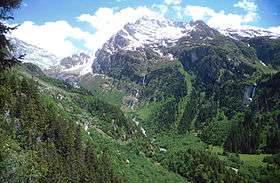 The Düssi from the Maderanertal | |
| Highest point | |
| Elevation | 3,256 m (10,682 ft) |
| Prominence | 429 m (1,407 ft) [1] |
| Parent peak | Schärhorn |
| Coordinates | 46°47′30.5″N 8°49′38.8″E / 46.791806°N 8.827444°ECoordinates: 46°47′30.5″N 8°49′38.8″E / 46.791806°N 8.827444°E |
| Geography | |
 Düssi Location in Switzerland | |
| Location | Graubünden/Uri, Switzerland |
| Parent range | Glarus Alps |
The Düssi (or Piz Git) is a mountain in the Glarus Alps in central Switzerland, located on the border between the cantons of Uri and Graubünden. Its massif separates the valleys of Maderanertal (Uri) and Val Russein (Graubünden). The summit (3,256 metres) is also named Gross Düssi to distinguish it from a lower summit (3,127 metres) named Chli Düssi.
The Düssi is surrounded by glaciers, the largest being the Hüfifirn on its northern side. The largest on its south-eastern side (in Graubünden) is the Glatscher da Cavrein.
References
External links
This article is issued from Wikipedia - version of the 6/14/2016. The text is available under the Creative Commons Attribution/Share Alike but additional terms may apply for the media files.