Döbling
| Döbling | ||
|---|---|---|
| 19th District of Vienna | ||
| ||
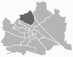 Location of the district within Vienna | ||
| Country | Austria | |
| City | Vienna | |
| Government | ||
| • District Director | Adolf Tiller (ÖVP) | |
| • First Deputy | Hannes Trinkl (ÖVP) | |
| • Second Deputy | Gerald Kopecky (SPÖ) | |
| • Representation (46 Members) |
ÖVP 18, SPÖ 15, FPÖ 7, Green 6 | |
| Area | ||
| • Total | 24.90 km2 (9.61 sq mi) | |
| Population (2016-01-01)[1] | ||
| • Total | 71,596 | |
| • Density | 2,900/km2 (7,400/sq mi) | |
| Postal code | A-1190 | |
| Address of District Office |
Gatterburggasse 14 A-1190 Wien | |
| Website | www.wien.gv.at/bezirke/doebling/ | |

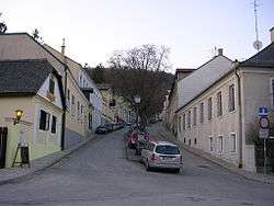
Döbling (German pronunciation: [ˈdøːblɪŋ]) is the 19th District in the city of Vienna, Austria (German: 19. Bezirk, Döbling, Doebling). It is located on the north end from the central districts, north of the districts Alsergrund and Währing.[2] Döbling has some heavily populated urban areas with many residential buildings, and borders the Vienna Woods.[1][2] It hosts some of the most expensive residential areas such as Grinzing, Sievering, Neustift am Walde and Kaasgraben and is also the site of a large number of Heurigen restaurants. There are also some large Gemeindebauten, including Vienna's most famous one, the Karl-Marx-Hof.
Also located in Döbling is the American International School of Vienna, Lauder Business School and Q19 Shopping Center.
Geography
Location
Döbling is located in the northwest of Vienna and spans the slope of the Wienerwald (Vienna Forest) to the Danube and the Danube Canal that make up the border of the district in the east. The Danube forms the border between Döbling and the district Floridsdorf, and the canal forms the border to the district Brigittenau. At the Gürtel Bridge, over the Donau Canal, the district border splits off and separates Döbling in the south along the Vienna Belt from the district Alsergrund. At the Schrottenbachgasse the district border branches towards the northwest and separates Döbling from the district Währing along the line Währinger Park-Hasenauerstraße-Peter Jordan Straße-Starkfriedgasse -Sommerhaidenweg. There is then a short border to the district Hernals at the edge of Vienna.
Space allocation
Nearly 32.6% of the Döbling district area is land (compared to Vienna city-wide as 33.3%). To 85.2% involves Housing areas; the proportion of Betriebsbaugebiete, as 2.2% of the district area, is very low (Vienna 7.6%). With a greenspace share as 51.8% (48.3% for Vienna), Döbling is the 5th greenist district of Vienna. It accounts for 14.9% of district land as agricultural land, while the vineyard here plays the biggest role around Grinzing, Nußdorf, Sievering, Neustift am Walde and Salmannsdorf. Further 25.4% of the district is forested, plus 5.3% in meadows, 2.7% in small gardens, 2.5% in parks, and 0.9% as sports and recreational areas. The remainder district territory has 11.0% in traffic/transport and 4.6% on water. While the proportion of water is higher in relation to the whole city of Vienna, the proportion on traffic is below.
Hills
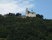
Across the large proportion of the Vienna Woods in Döbling, lie numerous hills of Vienna. Many lie on the border with Lower Austria and the neighboring districts. The highest summit is Hermannskogel (542 m, 1778 ft; even highest of Vienna) with an outlook tower; however, the symbols of Döbling are the Kahlenberg (484 m, 1588 ft) with an outlook and a radio mast, and the nearby Leopoldsberg (427 m, 1401 ft). Other hills in this region are: the Reisenberg, Latisberg, Vogelsangberg, Dreimarkstein and Nußberg. Besides, there are partially built-up elevations in Döbling, such as Hohe Warte in Heiligenstadt, the Hungerberg in Grinzing, and the Hackenberg in Sievering.

Waterways
In the district zone, numerous streams originate, but now are mostly hard-installed or led as stream canals. Originally they all flowed, with the exception of the Waldbach (forest stream), into the Danube canal. Because the catchment areas of the streams lie in the sandstone zone of the Viennese forest, the streams can and were able to grow on a multiple of its normal water quantity. This led again and again to destructive flood waters, especially along the Krottenbach. The Krottenbach was the most important stream in Döbling, and is led practically perfectly as a stream canal. It includes the area behind the federal secondary school Billrothstraße, underground, and through Sievering, joins into the Arbesbach (Erbsenbach) stream, which today in the upper run, still flows openly until Obersievering.
The Nesselbach passes yet to the Krapfenwaldl openly, before it unites underground with the Reisenbergbach stream in Grinzing. The Reisenbergbach stream passes openly at the same time yet until shortly before the center of Grinzing. Almost entirely in the open, the Schreiberbach stream passes up to Nußdorf and the Waldbach stream at Kahlenbergerdorf. Through diverting water, the Döblinger Bach stream has entirely disappeared. This sprang originally in the Cottage and flowed in the Spittelau into the Danube Canal.
District sectors

Döbling is formed by more, newer self-sufficient communities, including:
|
History
Etymology
Döbling was first mentioned in 1114 as "de Teopilic". The name derives from the Slavic * topl’ika ("swampy waters" or "swampy place").[3] The name "Döbling" relates to the lake of the Krottenbach stream, while further possibility of interpretation derives from Old Slavic Toplica ( "warm stream"). Later spellings of the place-name were for example Toblich, Töbling and Tepling. In the formation of the district 1890/92, the name was finally "Döbling", from the largest municipality, Oberdöbling, in the incorporated district.
Döbling in antiquity
The district Döbling had been settled over 5,000 years ago, while the area Döbling-Nußdorf-Heiligenstadt next to the area Simmering-Landstraße probably represents the oldest settlement area in the Vienna area. Known is that on the Leopoldsberg hill, a weapon-bearing village with a fortified tower existed in which the inhabitants of surrounding villages gathered at risk. About the residents of that time, little is known; science refers to them as makers of "Donauländischen" (Danube-land) culture; they were not however Indo-Germanic. These penetrated into the Vienna area until one thousand years later, where the resident population mixed with the immigrant Illyrians and Celtic people. The actions of the Romans, at the current site of Döbling, is revealed by several findings. So found were: in Heiligenstadt a fortified tower of the Limes (border wall); in Sievering a Mithraeum temple was found; and excavations in Heiligenstadt's church revealed a Roman cemetery. In Sievering in Roman times, a great quarry existed, with a large worker settlement. A further means of subsistence of the population was the vineyard, which presumably already operated before the Romans arrived. Otherwise, the people conducted agriculture for their own needs.
In Roman times, the garrison town Vindobona was established to cover a part of today's 1st District, the Innere Stadt. Within the boundaries of Döbling a tower of the Roman defence wall, the limes, remnants of a temple and tombstones from a cemetery have been unearthed. A quarry located in today's Sievering was operated in Roman times and would have been staffed by local quarry men.
Later events
Throughout the centuries the suburb, due to its strategic location (elevated in respect to the centre of Vienna) was occupied and often looted. The decisive encounter of the Battle of Vienna in 1683 was fought on September 12, between Jan III Sobieski and the forces of the Ottoman Empire, commanded by the Grand Vizier Kara Mustafa Pasha.
Politics
| District Directors from 1945 | |||
|---|---|---|---|
| Josef Friedl | 1891–1894 | Karl Mark (SPÖ) | 4/45–10/45 |
| Johann Österreicher | 1894–1895 | Karl Schwendner (SPÖ) | 10/45–1960 |
| Peter Langweber | 1895–1903 | Franz Opfermann (SPÖ) | 1960–1965 |
| Wenzel Kuhn | 1903–1919 | Franz Weber (SPÖ) | 1965–1975 |
| Josef Seleskowitsch | 1919–1934 | Richard Stockinger (SPÖ) | 1975–1978 |
| Franz Karasek | 1934–1938 | Adolf Tiller (ÖVP) | 1978– |
| Adolf Judex | 1938–1939 | ||
At the 2010 elections the FPÖ won 6.3% and reached 14.7% The Greens lost 0.3% and now have 13.6%. The ÖVP lost dramatically 4.3% and now only has 36.4%, the SPÖ lost 2.5% and now only has 31.8%. The BZÖ could practically double itself through winning of 0.6% up to now 1,3%, whereas the KPÖ reached 0.8% and is stagnating.
Social Development
Due to the hilly terrain, large forested areas - used as hunting grounds by the nobility - remained between the creeks and villages, spread throughout the district. The topology also attracted wine growers. This combination increased the prosperity of the suburb, as noblemen built villas and hunting lodges whilst the burghers of Vienna relaxed at the Heurigen wine-gardens. The existing villages expanded, as the population increased, until the district "Döbling" was established at the end of the 19th century, in 1892.
In the following years, Döbling developed as a district for the prosperous middle and upper class. In the period of the First Republic between World War I and World War II the Social Democrats also planned and erected many blocks of public housing. The Karl-Marx-Hof is one of the largest of these settlements (Siedlungen). The suburb of Döbling had a high percentage of Jewish residents and maintained a synagogue in the district. In the Reichskristallnacht this synagogue (like almost all others in Vienna) was destroyed.
Religious preferences
The distribution of religious preferences of the population in the 13th District, in 2001, differed most from the average in Vienna. With 55.7% of residents being Roman Catholic (Vienna: 49.2%), it is the second highest of all districts of Vienna. There are 11 districts of Roman Catholic parishes, the city Deanery 19 images. Also, the percentage of people with Protestant religion reached 6.5%, as one of the highest values of the districts in Vienna. The proportion of people with different religions are 4.0% known to Islam, 3.2% for the orthodoxy. About 23.8% said they had no religious community.
Education
The Japanische Schule in Wien, the Japanese school, is located in Döbling.[4]
Notable residents
- Ludwig van Beethoven (1770–1827), composer (Grinzinger Straße 64; Pfarrplatz 2; Probusgasse 6 (the Heiligenstadt Testament was drafted here); Döblinger Hauptstraße 92 (Beethoven composed substantial parts of the Eroica Symphony here)
- Kurt Gödel (1906–1978), Austrian-American mathematician, logician and philosopher (Himmelstraße 43)
- Mohamed ElBaradei (born 1942), former Director General of the International Atomic Energy Agency (IAEA), Nobel Peace Prize laureate
- Franz Grillparzer (1791–1872), poet (Grinzinger Straße 64)
- Bruno Kreisky (1911, Margareten, Vienna - 1990), former Chancellor of Austria (Armbrustergasse 15)
- Joseph Lanner (1801, Neubau, Vienna - 1843), composer (Gymnasiumstraße 87, building demolished in the late 19th century)
- Nikolaus Lenau (1802–1850), author
- Koloman Moser (1868, Wieden, Vienna - 1918), founding member of the Vienna Secession movement
- Helmut Qualtinger (1928, Alsergrund, Vienna - 1986), actor
- Romy Schneider (1938–1982), actress
- Johann Strauss I (1804–1849), composer (Dreimarksteingasse 13)
- Johann Strauss II (1825–1899), composer (Dreimarksteingasse 13)
- Hussein bin Talal, King of Jordan (1935–1999)
- Ambros Rieder (1771–1855), composer, organist (born in Döbling) (de)
- Leon Trotsky (1879–1940), Marxist theorist and Bolshevik revolutionary (Rodlergasse 25)
- Franz Vranitzky (born 1937), former Austrian Chancellor
- Franz Werfel (writer) and his wife, Alma Mahler-Werfel
- Simon Wiesental (1908–2005), Nazi hunter
- Hugo Wolf (1860–1903), composer
Sights
Notes
- 1 2 Statistik Austria, 2008, website: (in German: population is "Einwohner").
- 1 2 Wien.gv.at webpage (see below: References).
- ↑ Heinz D. Pohl: Slawische und slowenische (alpenslawische) Ortsnamen in Österreich.
- ↑ "学校概要." Japanische Schule in Wien. Retrieved on 2 January 2014. "Prandaugasse 2 1220 Wien AUSTRIA"
References
- [Parts of this article were translated from German Wikipedia.]
- "Wien - 19. Bezirk/Döbling", Wien.gv.at, 2008, webpage (15 subpages): Wien.gv.at-doebling (in German).
- Werner Filek-Wittinghausen: Gut gewerkt in Döbling: Beiträge und Dokumente zur Wirtschaftsgeschichte ("Good work in Döbling: Articles and Documents on Economic History"). Bastei, Vienna 1984, ISBN 3-85023-006-6.
- Christine Klusacek, Kurt Stimmer: Döbling. Vom Gürtel zu den Weinbergen ("Döbling: From the Belt to Weinberg Hill"). Vienna 1988, ISBN 3-900607-06-0.
- Helmut Kretschmer: Wiener Bezirkskulturführer: XIX. Döbling ("Vienna District Cultural Leader: XIX. Döbling"). Jugend und Volk, Vienna 1982, ISBN 3-7141-6235-6.
- Carola Leitner (Hg.): Döbling: Wiens 19. Bezirk in alten Fotografien ("Döbling: Vienna's 19th District in Old Photographs"). Ueberreuter, Vienna 2006, ISBN 3-8000-7177-0.
- Godehard Schwarz: Döbling. Zehn historische Spaziergänge durch Wiens 19. Bezirk ("Döbling: Ten Historic Walking Tours through Vienna's 19th District"). Vienna 2004, ISBN 3-900799-56-3.
- Franz Mazanec: Wien-Döbling. Frühere Verhältnisse. Sutton, Erfurt 2005. ISBN 978-3-89702-823-4.
External links
- (German) Bezirksmuseum Döbling
- (German) Döbling-Wien
- (German) wien.at - 19. Bezirk/Döbling
Coordinates: 48°15′59″N 16°19′22″E / 48.26639°N 16.32278°E
| Districts by Number |
|  |
|---|---|---|