Cyclone Les (1998)
| Category 2 tropical cyclone (Aus scale) | |
|---|---|
| Tropical storm (Saffir–Simpson scale) | |
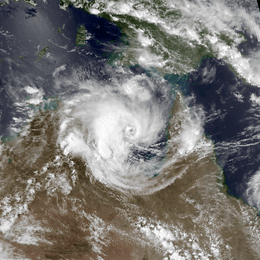 Tropical Cyclone Les on 24 January 1998 | |
| Formed | 19 January 1998 |
| Dissipated | 1 February 1998 |
| Highest winds |
10-minute sustained: 110 km/h (70 mph) 1-minute sustained: 95 km/h (60 mph) Gusts: 140 km/h (85 mph) |
| Lowest pressure | 976 hPa (mbar); 28.82 inHg |
| Fatalities | 3 direct |
| Damage | $64.7 million (1998 USD) |
| Areas affected | Queensland, Northern Territory, Western Australia |
| Part of the 1997–98 Australian region cyclone season | |
Tropical Cyclone Les was a Category 2 storm in the 1997–98 Australian region cyclone season, which affected the Northern Territory of Australia in January 1998.
Meteorological history
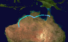
On January 19, 1998, an area of low pressure developed over the Gulf of Carpentaria. Little development occurred as the system traveled initially towards the southwest and later towards the east. Late on January 21, the low moved over the Cape York Peninsula and began to strengthen.[1] A surge of moisture from a northwest monsoon and a tightening pressure gradient due to an area of high pressure located over the Great Australian Bight, allowed the system to develop. The first warning published by the Australian Bureau of Meteorology was issued on January 23, after the storm had moved back over the Gulf of Carpentaria.[2]
Impact and aftermath
The intense rainfall also occurred during "king high tides" in the Timor Sea that pushed water from the lower reaches upstream, as a result, floodwater drainage was impeded. Many residents were evacuated to cyclone shelters. Several people were stranded on rooftops, and 3 people drowned during the storm. The cyclone dumped over 380mm of rainfall in the area within a 48-hour period. The flooding forced at least 2,000 people out of their homes as 2 m (6.5 ft) of muddy water inundated Katherine, Northern Territory.[3] Total damages from the storm amounted to at least A$100 million ($64.7 million USD).[1] On January 27, a state of emergency was declared for Katherine as the Katherine River reached a level of 20.3 m (66.6 ft). Two days later, 392 residents were evacuated from the Daly River region by helicopter due to the threat of flooding. The following day, Prime minister John Howard visited the flooded areas in Katherine and requested A$5 million ($3.2 million USD) to repair the Stuart Highway and assist residents in need of aid.[4]
See also
References
- 1 2 "Tropical Cyclone Les". Australian Bureau of Meteorology. 2009. Retrieved 22 February 2009.
- ↑ Gary Padgett (14 May 1998). "Monthly Tropical Weather Summary for January 1998". Typhoon 2000. Retrieved 22 February 2009.
- ↑ Staff Writer (2007). "No Stranger to Floods". Relief in Sight. Archived from the original on 15 June 2007. Retrieved 22 February 2009.
- ↑ Staff Writer (22 February 1998). "Northern Territory Chronicle 1998" (PDF). Northern Territory Chronicle.