Cut and Shoot, Texas
| Cut and Shoot, Texas | |
|---|---|
| City | |
|
The City Hall of Cut and Shoot, Texas | |
 Location of Cut and Shoot, Texas | |
| Coordinates: 30°20′14″N 95°21′46″W / 30.33722°N 95.36278°WCoordinates: 30°20′14″N 95°21′46″W / 30.33722°N 95.36278°W | |
| Country | United States |
| State | Texas |
| County | Montgomery |
| Area | |
| • Total | 2.7 sq mi (7.0 km2) |
| • Land | 2.7 sq mi (7.0 km2) |
| • Water | 0.0 sq mi (0.0 km2) |
| Elevation | 190 ft (58 m) |
| Population (2000) | |
| • Total | 1,158 |
| • Density | 426.0/sq mi (164.5/km2) |
| Time zone | Central (CST) (UTC-6) |
| • Summer (DST) | CDT (UTC-5) |
| ZIP codes | 77303, 77306 |
| Area code(s) | 936 |
| FIPS code | 48-18260[1] |
| GNIS feature ID | 1381207[2] |

As a municipality incorporated in 1969, Cut and Shoot is a city in eastern Montgomery County, Texas, United States, about 6 miles east of Conroe and 40 miles north of Houston. Until 2006, Cut and Shoot was considered and called a "town". Then, the town council elected for it to be considered and referred to as a "city". The population was 1,070 at the 2010 census.[3]
Name
According to one local legend, Cut and Shoot was named after a 1912 community confrontation that almost led to violence. According to differing versions of the story, the dispute was either over:[4]
- The design of a new steeple for the town's only church,
- The issue of who should be allowed to preach there, or
- The conflicting land claims among church members.
Whatever the circumstances were, a small boy at the scene reportedly declared "I'm going to cut around the corner and shoot through the bushes in a minute!" This statement apparently stayed in the residents' minds and was eventually adopted as the town's name.[5] It has frequently been noted on lists of unusual place names.[6][7]
History
The town of Cut and Shoot gained fame when local boxer Roy Harris, a heavyweight contender, fought Floyd Patterson for the heavyweight title in 1958. Harris appeared on the cover of Sports Illustrated and was featured in Life Magazine. So much mail was addressed to "Roy Harris, Cut and Shoot, Texas" that the U. S. Postal Service granted a franchise post office to the town.
Population statistics were not reported for the community until the mid-1970s, when the number of residents was 50. By 1980 the incorporated community reported a population of 809, had a new city hall and supported both a school and several businesses.
Geography
According to the United States Census Bureau, the town had a total area of 2.7 square miles (7.0 km2), all of it land.
Demographics
| Historical population | |||
|---|---|---|---|
| Census | Pop. | %± | |
| 1970 | 451 | — | |
| 1980 | 568 | 25.9% | |
| 1990 | 903 | 59.0% | |
| 2000 | 1,158 | 28.2% | |
| 2010 | 1,070 | −7.6% | |
| Est. 2015 | 1,105 | [8] | 3.3% |
As of the census[1] of 2000, there were 1,158 people, 389 households, and 324 families residing in the town. The population density was 426.0 people per square mile (164.4/km²). There were 410 housing units at an average density of 150.8 per square mile (58.2/km²). The racial makeup of the town was 92.92% White, 0.52% African American, 1.47% Native American, 0.09% Asian, 3.63% from other races, and 1.38% from two or more races. Hispanic or Latino of any race were 6.39% of the population.
There were 389 households out of which 37.5% had children under the age of 18 living with them, 72.5% were married couples living together, 9.3% had a female householder with no husband present, and 16.5% were non-families. 13.4% of all households were made up of individuals and 5.4% had someone living alone who was 65 years of age or older. The average household size was 2.98 and the average family size was 3.24.
In the town the population was spread out with 29.1% under the age of 18, 7.6% from 18 to 24, 29.3% from 25 to 44, 23.1% from 45 to 64, and 10.9% who were 65 years of age or older. The median age was 35 years. For every 100 females there were 100.3 males. For every 100 females age 18 and over, there were 97.4 males.
The median income for a household in the town was $40,455, and the median income for a family was $47,404. Males had a median income of $36,719 versus $20,833 for females. The per capita income for the town was $15,482. About 5.7% of families and 8.9% of the population were below the poverty line, including 7.5% of those under age 18 and 15.5% of those age 65 or over.
Government and infrastructure
The City of Cut and Shoot is one of the very few statewide municipalities that has no ad valorem property tax within its city limits. The only tax based city income is from a 1% sales tax on taxable goods and services within the city limits.
The United States Postal Service Cut and Shoot Post Office is located at 13985 Texas State Highway 105 East.[10]
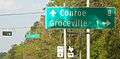
Cut And Shoot includes Groceville, an Unincorporated Populated Place of Montgomery County.[11][12]
Education
Cut and Shoot is within the Conroe Independent School District and the Lone Star College System (formerly North Harris Montgomery Community College District).
Schools serving Cut and Shoot include Austin Elementary School,[13] Grangerland Intermediate School,[14][15] Moorhead Junior High School,[15][16] and Caney Creek High School[15][17]
Notable person
Debra Maffett, named Miss America 1983, hailed from Cut and Shoot.[18]
References
- 1 2 "American FactFinder". United States Census Bureau. Archived from the original on 2013-09-11. Retrieved 2008-01-31.
- ↑ "US Board on Geographic Names". United States Geological Survey. 2007-10-25. Retrieved 2008-01-31.
- ↑ Population Estimates Boundary Changes Archived August 6, 2010, at the Wayback Machine., United States Census Bureau, 2007-07-01. Accessed 2008-11-06.
- ↑ Handbook of Texas Online (30 May 2010). "CUT AND SHOOT, TEXAS". Texas State Historical Association. Retrieved 19 October 2010.
- ↑ "HOW CUT AND SHOOT GOT ITS NAME". City of Cut And Shoot, Texas. 10 August 2006. Retrieved 19 October 2010.
- ↑ Parker, Quentin (2010). Welcome to Horneytown, North Carolina, Population: 15: An insider's guide to 201 of the world's weirdest and wildest places. Adams Media. pp. ix.
- ↑ Birnbach, Lisa; Marx, Patricia; Hodgman, Ann (14 May 2002). 1,003 Great Things About America. Andrews McMeel Publishing. p. 165. ISBN 978-0-7407-2949-2.
- ↑ "Annual Estimates of the Resident Population for Incorporated Places: April 1, 2010 to July 1, 2015". Retrieved July 2, 2016.
- ↑ "Census of Population and Housing". Census.gov. Archived from the original on May 11, 2015. Retrieved June 4, 2015.
- ↑ "Post Office Location - CUT AND SHOOT." zip: 77306-5454 United States Postal Service. Retrieved on December 8, 2008.
- ↑ Groceville at Histopolis.
- ↑ Caney Creek, Texas State Historical Association.
- ↑ "Conroe Independent School District Conroe Elementary Feeder Map School Year 2010-2011." Conroe Independent School District. Retrieved on January 20, 2011.
- ↑ "Conroe Independent School District Conroe Intermediate Feeder Map School Year 2010-2011." Conroe Independent School District. Retrieved on January 20, 2011.
- 1 2 3 "Conroe Independent School District Caney Creek High School, Junior High School and Intermediate Feeder Map School Year 2010-2011." Conroe Independent School District. Retrieved on January 20, 2011.
- ↑ "Conroe Independent School District Conroe Junior High Feeder Map School Year 2010-2011." Conroe Independent School District. Retrieved on January 20, 2011.
- ↑ "Conroe Independent School District Conroe High Feeder Map School Year 2010-2011." Conroe Independent School District. Retrieved on January 20, 2011.
- ↑ Montgomery, Roy Harris and Robin (17 November 2012). Roy Harris of Cut and Shoot: Texas Backwoods Battler. iUniverse. p. 19. ISBN 978-1-4759-6068-6.
External links
- City of Cut And Shoot
- Robin N. Montgomery, "CUT AND SHOOT, TX," Handbook of Texas Online, accessed October 29, 2012. Published by the Texas State Historical Association.
- Cut And Shoot at Histopolis.
Gallery
-

Sign on TX Hwy 105 eastbound at the corner of Loop 336.
-

Cut And Shoot Post Office.
-
Sign on TX Hwy 105 westbound at the corner of FM 1484.
-

Outskirts of the hamlet of Groceville.
-

Austin Elementary School, Cut & Shoot, TX.
-

Cut And Shoot City Park.
-

Cut And Shoot Park Playground.
-

Cut And Shoot Fire Dept.
-
.JPG)
Prairie Larkspur (Delphinium carolinianum) growing wild in Cut And Shoot, Montgomery County, Texas.
Municipalities and communities of Montgomery County, Texas, United States | ||
|---|---|---|
| Cities | 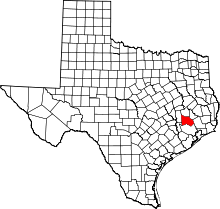 | |
| Towns | ||
| CDPs | ||
| Unincorporated communities | ||
| Ghost town | ||
| Footnotes | ‡This populated place also has portions in an adjacent county or counties | |
