Cut River
| Cut River | |
| River | |
 Cut River | |
| Country | United States |
|---|---|
| State | Michigan |
| Region | Upper Peninsula |
| Source | Mackinac County |
| - coordinates | 46°04′33″N 85°07′12″W / 46.0759°N 85.1201°W |
| Mouth | Lake Michigan |
| - coordinates | 46°02′40″N 85°07′36″W / 46.0445°N 85.1267°WCoordinates: 46°02′40″N 85°07′36″W / 46.0445°N 85.1267°W |
| Length | 4 mi (6 km) |
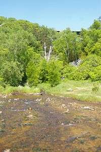
Cut River is a small, short river in the Upper Peninsula of the U.S. state of Michigan. The 4-mile (6.5 km) river runs along the boundary between Hendricks Township and Moran Township, with the mouth on Lake Michigan about two miles east of Epoufette and about four miles west of Brevort.[1]
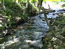
It drains part of the Little Brevoort wetland through a steep-sided limestone gorge into northern Lake Michigan. The river's drainage is largely located within the Lake Superior State Forest and is administered by the Michigan Department of Natural Resources.
Cut River is notable for two features:
- The Cut River Bridge, carrying U.S. Highway 2 over the Cut River close to its mouth, is one of the longest truss arch bridges in the United States, and is the eighth longest bridge in Michigan.[2] Completed in 1947, the bridge is 641 feet (195 m) long,[3] and rises 140 feet (43 m) above the base of the gorge. Parking is available at both ends of the bridge, and there is a pedestrian footpath on the north side of the bridge, offering a good view of the gorge.[4] Locals call the bridge "the million dollar bridge over a two-bit creek."[2]
- The Cut River gorge is well adapted to growth of mature sugar maple specimens. The bridge and footpath, which rise just above treetop level, offer good views of the gorge during the autumn color season. Hiking trails descend from both ends of the bridge down into the river valley, with a spur to the Lake Michigan shoreline.[5]
It should not be confused with the natural waterway that runs between Higgins Lake and Houghton Lake in the lower peninsula of Michigan, which is also called "Cut River"
References
- ↑ Michigan Atlas and Gazetteer (10th ed.). Yarmouth, ME: DeLorme. 2002.
- 1 2 "Cut River Bridge". Letterboxing North America. Retrieved 2006-10-07.
- ↑ Hyde, Charles (2002-05-13). "US 2 / Cut River". Historic Highway Bridges of Michigan. Michigan Department of Transportation. Retrieved 2006-10-07.
- ↑ Hunt, Mary; Hunt, Don. "Epoufette: Cut River Bridge & Picnic Area". Hunts' Guide to Michigan's Upper Peninsula. Albion, MI: Midwestern Guides. Retrieved 2006-10-07.
- ↑ "31 Cut River Bridge". Wildlife Viewing Guide. Michigan Department of Natural Resources. Retrieved 2006-10-07.
| Wikimedia Commons has media related to Cut River. |