Cumulus congestus cloud
| Cumulus congestus cloud | |
|---|---|
 A example of cumulus congestus clouds visible in the distance. | |
| Abbreviation | TCu |
| Symbol |
|
| Genus | Cumulus (heaped) |
| Species | congestus |
| Altitude |
up to 6,000 m (up to 20,000 ft) |
| Classification | Family D (Vertically developed) |
| Appearance | sharp outlines and great vertical development |
| Precipitation cloud? | common,[1] but usually not heavy.[2] |
Cumulus congestus clouds, also known as towering cumulus, are a form of cumulus cloud that can be based in the low or middle height ranges. They achieve considerable vertical development (family D2) in areas of deep, moist convection. They are an intermediate stage between cumulus mediocris and cumulonimbus.
Description
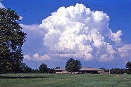
Cumulus congestus clouds are characteristic of unstable areas of the atmosphere which are undergoing convection. They are often characterized by sharp outlines and great vertical development.[3] Because they are produced by strong updrafts, they are typically taller than they are wide, and cloud tops can reach 6 kilometres (20,000 ft),[4] or higher in the tropics.[1] Cumulus congestus clouds are formed by the development of cumulus mediocris generally, though they can also be formed from altocumulus castellanus or stratocumulus castellanus as well.[3] The congestus species of cloud can only be found in the genus cumulus[3] and is designated as towering cumulus (Tcu) by the International Civil Aviation Organization. Congestus clouds are capable of producing severe turbulence and showers of moderate to heavy intensity. This species is classified as vertical or multi-étage and is coded CL2 in the synop report. These clouds are usually too large and opaque to have any opacity or pattern-based varieties.
Pyrocumulus (No official abbreviation) is a free convective cloud associated with volcanic eruptions and large-scale fires. Pyrocumulus is not recognized by the WMO as a distinct genus or species, but is, in essence, cumulus congestus formed under special circumstances that can also cause severe turbulence.
Cumulus congestus will mature into cumulonimbus calvus under conditions of sufficient instability. This transformation can be seen by the presence of smooth, fibrous, or striated aspects assumed by the cloud's upper part. This cloud type produces precipitation, often in abundance.
An approaching weather front often brings mid level clouds such as altostratus or altocumulus which usually stop any cumulus from reaching the congestus stage by reducing the Sun's heat or acting as a layer of stable air through which the cumulus cannot rise through. Occasionally, however, particularly if the air below the mid level cloud is very warm or unstable, some of the cumuli may become congestus and the tops of them may rise above the mid level cloud layer, sometimes resulting in showers ahead of the main rainband. This is often a sign that the approaching front contains at least a few cumulonimbi amongst the nimbostratus rain clouds and therefore any rain may be accompanied by thunderstorms.
Formation
The Cumulus Congestus cloud can form from the Cumulus mediocris cloud and the Cumulus humilis cloud. The warm air that has fed the cloud's formation from its birth is leading it to near freezing temperatures. As the air has been rising the temperatures have cooled. Though it has not reached freezing yet therefore retaining its cauliflower like shape. This is the last stage before becoming a cumulonimbus cloud.[5]
Turkey tower
.jpg)
Turkey tower is slang for a narrow, individual towering cloud from a small cumulus cloud which develops and suddenly falls apart.[6] Sudden development of turkey towers could signify the breaking or weakening of a capping inversion.[7]
| Wikimedia Commons has media related to Cumulus congestus clouds. |
See also
Bibliography
References
- 1 2 Richard H. Johnson; Thomas M. Rickenbach; Steven A. Rutledge; Paul E. Ciesielski; Wayne H. Schubert. "Trimodal Characteristics of Tropical Convection". Journal of Climate. American Meteorological Society. Bibcode:1999JCli...12.2397J. doi:10.1175/1520-0442(1999)012<2397:tcotc>2.0.co;2.
- ↑ See "Weather Photo Gallery". University of Utah Department of Meteorology.
- 1 2 3 "Glossary of Meteorology". American Meteorological Society.
- ↑ See "Life Cycle of a Thunderstorm". JetStream - Online School for Weather. National Weather Service.
- ↑ "CloudAppreciation". Retrieved 2014-11-04.
- ↑ "Weather Glossary - T". The Weather Company. Weatherzone. Retrieved 2009-02-21.
- ↑ "National Weather Service Glossary". National Oceanic and Atmospheric Administration. Central Region Headquarters. Retrieved 2009-02-21.