Cù Lao Ré volcanic islands
| Cu Lao Re Group | |
|---|---|
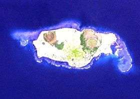 Satellite photo of Cu Lao Re by NASA | |
| Highest point | |
| Elevation | 181 m (594 ft) [1] |
| Coordinates | 15°23′N 109°07′E / 15.38°N 109.12°E |
| Geography | |
| Location | Northeast of Quang Ngai, Vietnam |
| Geology | |
| Age of rock | Holocene |
| Mountain type | Volcanic field |
| Last eruption | Unknown |
Cù-Lao Ré is a volcanic field northeast of Quảng Ngãi, Vietnam. The field consists of 13 volcanic cones; four subaerial and nine submarine. Three of the subaerial cones formed the Cù-Lao Ré Island, while the fourth one formed the Cù-Lao Bai Island.[1]
The Culao Re islands were used as a geographical landmark for navigation by Admiral Zheng He's crew during the 15th-century treasure voyages.[2]
See also
References
- 1 2 "Cù-Lao Ré Group". Global Volcanism Program. Smithsonian Institution. Retrieved 2009-08-26.
- ↑ Mills, J.V.G. (1970). Ying-yai Sheng-lan: 'The Overall Survey of the Ocean's Shores' [1433]. Cambridge: Cambridge University Press. pp. 17–8. ISBN 0-521-01032-2.
This article is issued from Wikipedia - version of the 8/10/2015. The text is available under the Creative Commons Attribution/Share Alike but additional terms may apply for the media files.