Crow Creek Indian Reservation
| Crow Creek Indian Reservation | ||
|---|---|---|
| Reservation | ||
| ||
 Location of Crow Creek Indian Reservation, South Dakota | ||
| Country | United States | |
| State | South Dakota | |
| Counties | Buffalo / Hughes / Hyde | |
| Government | ||
| • Governing body | Crow Creek Sioux Tribal Council | |
| Area | ||
| • Total | 196.235 sq mi (508.248 km2) | |
| Population (2004) | ||
| • Total | 1,230 | |
| Time zone | CST (UTC-6) | |
| • Summer (DST) | CDT (UTC-5) | |
| Website | South Dakota Tribal Government Relations: Crow Creek Sioux Tribe | |

The Crow Creek Indian Reservation (Lakota: 'Kȟaŋğí Wakpá Oyáŋke'[1]) is located in parts of Buffalo, Hughes, and Hyde counties on the east bank of the Missouri River in central South Dakota in the United States. It has a land area of 421.658 square miles (1,092.09 km2) and a 2000 census population of 2,225 persons. The major town and capital of the Crow Creek Sioux Tribe is Fort Thompson.
The town is located adjacent to the Big Bend Dam, which holds back Big Bend Reservoir (also known as Lake Sharpe), one of the four Missouri Mainstem reservoirs constructed by the US Army Corps of Engineers in the Pick-Sloan Plan. Authorized in 1944 for flood control and hydropower, the dam and lake were completed in the 1960s.
History
The people of the Crow Creek Sioux Tribe include Dakota and Lakota, descendants of ancestors who settled on the reservation after escape or exile from Minnesota following the Dakota War of 1862 in Minnesota. They were relocated from de-established Indian reservations further east in South Dakota. Although considered to be a part of the Great Sioux Reservation by some writers, the Crow Creek Reservation, established in 1862, has always been separate.
The reservation originally included bottom lands along the Missouri, which had been farmed previously by Mandan and Arikara, and others prior to these tribes. The peoples were decimated in smallpox and other epidemics in the 18th century. Today several former Mandan and Arikara villages are archaeological sites located within the Crow Creek Reservation.
Within the reservation are two pre-contact archeological sites that have been designated as National Historic Landmarks. Fort Thompson Mounds is an archeological site from c. 800, with evidence of some of the first pottery makers on the plains. The Crow Creek Massacre Site has revealed evidence of fierce conflict between Native American cultures about 1325 AD, likely when they were competing for resources at a time of climate and habitat change.[2][3]
The development of Lake Sharpe following completion of the Big Bend Dam flooded much of this land, forcing relocation of Fort Thompson and other settlements. Loss of the most productive, fertile bottomlands worsened the economic conditions in the area. Allotment and land sales reduced the amount of land in both tribal and Indian ownership, and the size of the Reservation was reduced by governmental action between its establishment in 1862 and modern times.
The reservation, and the Crow Creek Sioux Tribe, is organized into three districts. The tribe runs its own school, the Crow Creek Tribal Schools system, with an elementary school at Fort Thompson and a K-12 boarding and day school at Stephan, approximately 10 miles (16 km) north of Fort Thompson. Most of the tribe's land is leased to a few large ranching families. Unemployment is high.
The tribe operates the Lode Star Casino and Hotel, attracting tourists to the reservation; as well as to the archaeological sites, Lake Sharpe's fishing and boating, and casual travelers. The reservation is located southeast of Pierre and north of Chamberlain. It is reached via South Dakota Highway 47 or South Dakota Highway 50 off Interstate 90, or via South Dakota Highway 34 east from Pierre.
The Lower Brule Indian Reservation is located on the west bank of the Missouri River, directly across from the Crow Creek Reservation.
In 2002 a monument was dedicated at Big Bend Dam. The Spirit of the Circle Monument honors the more than 1,300 people who died of malnutrition and exposure over a three-year period in the 1860s at the reservation following the forcible removal of the Santee Dakota to this site, which resulted from their defeat in the Dakota War of 1862.[4]
Tribal information
- Reservation: Crow Creek Reservation; Buffalo, Hyde, and Hughes counties
- Division: Santee, Yankton
- Bands: Mdewakanton (People of Spirit Lake), Ihanktonwan (People of the End)
- Land Area: 125,591 acres (508.25 km2)
- Tribal Headquarters: Fort Thompson, SD
- Time Zone: Central
- Traditional Language: Dakota
- Enrolled members living on reservation: 1,230
- Major industry: Agriculture
Government
- Charter: None; Constitution and Bylaws: Yes
- Date Approved: April 26, 1949
- Name of Governing Body: Crow Creek Sioux Tribal Council
- Number of members: six (6) council members
- Dates of Constitutional amendments: February 25, 1963, June 23, 1980, February 4, 1986
- Number of Executive Officers: (1) Chairman
Elections
- Election of all six council members and the Chair are held every two years on the third Tuesday in April. The Chairman is elected at large by all districts. Tribal Council elects from within a Vice-Chairman, Treasurer and Secretary.
- If terms of office are staggered: No
- Number of Election districts or communities: 3
Council Meetings
- Regular meetings are held once a month.
- Quorum number: 4 members
Notable tribal members
- Oscar Howe (1915–1983), Yanktonai, modernist painter. Howe was born on the Crow Creek Reservation. Throughout his life, he received many honors, including the title Artist Laureate of South Dakota. Howe created a legacy of cultural heritage and pride. More than 20 Oscar Howe originals are on display at the Oscar Howe Art Center in Mitchell, South Dakota.
- Elizabeth Cook-Lynn taught Native American Studies for 20 years before becoming a full-time writer. She is the author of two novels and a collection of short stories. She edits the Wicazo Sa (Red Pencil) Review, an international Native American studies journal. She is also a traditional dancer on the powwow circuit. Cook-Lynn grew up on the Crow Creek Reservation.
- Crow Creek is where Shawn Hawk, world-rated professional boxer, has some roots.
- Vernon Ashley was the oldest member of the Crow creek Sioux Tribe. Ashley died at 99 in November, 2015. He had an extensive knowledge of Native American laws and treaties, as well as the Sioux language. Ashley helped in developing the constitution by-laws (red book) that the Crow Creek Sioux Tribe uses today.
See also
Notes
- ↑ Ullrich, Jan, ed. (2011). New Lakota Dictionary (2nd ed.). Bloomington, IN: Lakota Language Consortium. p. 900. ISBN 978-0-9761082-9-0. LCCN 2008922508.
- ↑ Bamforth, Douglas and Curtis Nepstad-Thornberry, 2007. "Reconsidering the Occupational History of the Crow Creek Site (39BF11)", Plains Anthropologist 52 (202:153-173).
- ↑ Gregg, John B. and Pauline Gregg, 1987. Dry Bones: Dakota Territory Reflected. University of South Dakota Press: Vermillion.
- ↑ Melmer, David (June 19, 2002). "Dakota sacrifice honored". Indian Country Today. Retrieved 2008-09-27.
References
- Environmental Assessment, Crow Creek Tribal School, Nathan A. Barton, Wasteline, Inc. 2004.
- Crow Creek Reservation, South Dakota United States Census Bureau
External links
| Wikimedia Commons has media related to Crow Creek Agency. |
- Crow Creek Reservation, official website
- "Crow Creek: Stolen Lands, Wind Farms and Taking a Stand for the People", NDN News, 19 December 2009
- Crow Creek Sioux Tribe Infrastructure Development Trust Fund Act of 1996
Coordinates: 44°07′44″N 99°28′26″W / 44.12889°N 99.47389°W
1 No reservation in the state, trust lands or legal status only |
Municipalities and communities of Buffalo County, South Dakota, United States | ||
|---|---|---|
| CDP |  | |
| Unincorporated community | ||
| Township |
| |
| Unorganized territories |
| |
| Indian reservation | ||
| Footnotes | ‡This populated place also has portions in an adjacent county or counties | |
Municipalities and communities of Hughes County, South Dakota, United States | ||
|---|---|---|
| Cities | 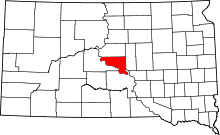 | |
| Town | ||
| Indian reservation | ||
| Unincorporated communities | ||
| Footnotes | ‡This populated place also has portions in an adjacent county or counties | |
Municipalities and communities of Hyde County, South Dakota, United States | ||
|---|---|---|
| City | 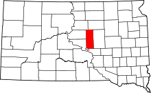 | |
| Unincorporated communities | ||
| Indian reservation | ||
| Footnotes | ‡This populated place also has portions in an adjacent county or counties | |