Cross River (Nigeria)
.jpg)
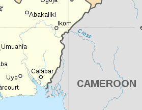
Cross River (of which its native name is Oyono)[1] is the main river in southeastern Nigeria and gives its name to Cross River State. It originates in Cameroon, where it takes the name of the Manyu River.[2] Although not long by African standards its catchment has high rainfall and it becomes very wide. Over its last 80 kilometres (50 mi) to the sea its flows through swampy rainforest with numerous creeks and forms an inland delta near its confluence with the Calabar River,[3] about 20 kilometres (12 mi) wide and 50 kilometres (31 mi) long between the cities of Oron on the west bank and Calabar, on the east bank, more than 30 kilometres (19 mi) from the open sea. The delta empties into a broad estuary which it shares with a few smaller rivers. At its mouth in the Atlantic Ocean, the estuary is 24 kilometres (15 mi) wide. The eastern side of the estuary is in the neighbouring country of Cameroon.
The major tributary of cross river is the river Aloma coming from Benue State to merge with the cross river in cross river state. Cross River State is connected with a major highway to its sister state Akwa Ibom. The distance between Oron and Calabar is 21 kilometres (13 mi) by boat and about 200 kilometres (120 mi) by road. The population of the lower Cross River traditionally use water transport and Calabar has long had a major seaport, in the Calabar River about 10 kilometres (6 mi) from its confluence with the Cross River and about 55 kilometres (34 mi) from the sea. The Itu bridge on the Cross River is along Itu-Calabar highway and is reported to be one of the landmark achievements of the Gowon administration when it was completed in 1975.
The Cross River forms a boundary between two tropical moist forest ecoregions, the Cross-Niger transition forests which lie west of the river, between the Cross and Niger Rivers, and the Cross-Sanaga-Bioko coastal forests, which lie to the east between the Cross River and the Sanaga River of Cameroon.
References
- ↑ Reclus, Élisée (1892). Africa. 3 (reprint ed.). Forgotten Books. p. 341. ISBN 1-4400-9130-7.
- ↑ L. Zapfack; J. S. O. Ayeni; S. Besong; M. Mdaihli (November 2001). "ETHNOBOTANICAL SURVEY OF THE TAKAMANDA FOREST RESERVE" (PDF). Archived from the original (PDF) on 2011-07-08. Retrieved 2011-02-05.
- ↑ Maritime Organisation of West and Central Africa, Nigeria
External links
Coordinates: 4°35′N 8°25′E / 4.583°N 8.417°E