Cross Bronx Expressway
| |
|---|---|
|
Map of the Bronx in New York City with Cross Bronx Expressway highlighted in red | |
| Route information | |
| Maintained by NYSDOT | |
| Length: | 6.5 mi[1][2] (10.5 km) |
| Existed: | 1955[3] – present |
| Component highways: |
|
| Major junctions | |
| West end: |
|
|
| |
| East end: |
|
| Highway system | |
.svg.png)

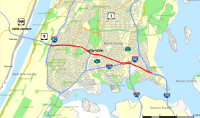
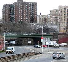
The Cross Bronx Expressway is a major freeway in the New York City borough of the Bronx, conceived by Robert Moses and built between 1948 and 1972. It carries traffic on Interstate 95 (I-95) through the city, and serves as a portion of I-295 toward Long Island; a portion is also designated U.S. Route 1 (US 1). The Cross Bronx begins at the Alexander Hamilton Bridge over the Harlem River, where the Trans-Manhattan Expressway continues west across Upper Manhattan to the George Washington Bridge. While I-95 leaves at the Bruckner Interchange in Throgs Neck, following the Bruckner Expressway and New England Thruway to Connecticut, the Cross Bronx Expressway Extension continues east, carrying I-295 to the merge with the Throgs Neck Expressway near the Throgs Neck Bridge. Though the road goes primarily northwest-to-southeast, the nominal directions of all route numbers west of the Bruckner Interchange are aligned with the northbound route number going southeast, and the southbound route number going northwest.
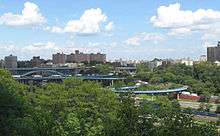
The Cross Bronx Expressway was the first highway built through a crowded urban environment; the most expensive mile of road ever built to that point is part of the Cross Bronx, costing 40 million dollars (equivalent to $353,937,888 in 2015). At one point during construction, Moses' crews had to support the Grand Concourse (a major surface thoroughfare), a subway line and several elevated train lines at Westchester Avenue, Boston Road, Third Avenue, and Jerome Avenue while the expressway was laboriously pushed through. The highway has severe traffic problems, and its construction has been blamed for negatively affecting a number of low-income neighborhoods in the South Bronx.
Route description
The Cross Bronx Expressway begins at the eastern end of the Alexander Hamilton Bridge as a continuation of the Trans-Manhattan Expressway and officially designated as both I-95 and US 1. Immediately after coming off the bridge, there is an interchange with the Major Deegan Expressway (I-87) for Yankee Stadium and points upstate. The highway soon intersects with Webster Avenue at a partial interchange allowing eastbound vehicles to exit and westbound ones to enter. Northbound US 1 leaves the Cross Bronx Expressway at this exit. About one and half miles later, comes a pair of closely spaced interchanges for the Sheridan Expressway (I-895) and the Bronx River Parkway. The exit for the Sheridan Expressway is an incomplete interchange and allows access from northbound and to southbound I-95 only.
The Cross Bronx Expressway reaches the Bruckner Interchange two miles (3 km) later. Going eastbound (I-95 northbound), the interchange allows access to southbound I-678, northbound I-95 (Bruckner Expressway) and southbound I-295. I-95 leaves the Cross Bronx Expressway here and continues north along the Bruckner Expressway. The Cross Bronx Expressway continues east of the interchange as I-295, which begins here. The Cross Bronx ends 1.5 miles (2.4 km) later at the Throgs Neck Expressway, where traffic from I-695 merges on towards the Throgs Neck Bridge.[4]
History
The 1929 Report on Highway Traffic Conditions and Proposed Traffic Relief Measures for the City of New York was the first citywide traffic study, classifying a number of projects that had been proposed by local interests. A "Cross-Bronx Route" along 161st and 163rd Streets was one of two proposed facilities, along with the "Nassau Boulevard" (which became the Long Island Expressway), picked by borough engineers as examples of important projects.[5] Although this routing was south of the present Cross Bronx Expressway, the report did suggest a "New Cross-Bronx Artery" near the present expressway that would link the Washington Bridge with the Clason Point Ferry to Queens. Though it would not be built to freeway standards, it would be 60 feet (18 m) wide with grade separations "where considered necessary and desirable." The George Washington Bridge, then under construction, was cited among reasons to build the highway which would help connect New Jersey to Long Island via the bridges and ferry.[6]
In 1936, the Regional Plan Association (RPA) proposed a cross-Bronx highway which would connect the George Washington, Triborough, and Bronx–Whitestone bridges, as well as access to points north to New England. In late 1940, the New York City Planning Commission adopted a plan for a network of highways. Except for the Bronx and Pelham Parkway, which lay to the north, no cross-Bronx highway had been built up to this point.[7] The report stated that the "Bronx Crosstown Highway", which would now connect on the east end to the Bronx–Whitestone Bridge (which had replaced the Clason Point Ferry), was "an essential part of a desirable highway pattern", taking traffic from the George Washington Bridge to Long Island and New England. The cost was estimated at $17,000,000, higher than most improvements because of the "topographical conditions, high land values, and heavily built-up areas".[8]
Robert Moses proposed a six-lane expressway to run through the middle of the Bronx in 1945. This project proved to be one of the most difficult expressway projects at the time; construction required blasting through ridges, crossing valleys and redirecting small rivers. In doing so, minimal disruption to the apartment buildings that topped the ridges in the area of Grand Concourse was a priority. Moreover, the expressway had to cross 113 streets, seven expressways and parkways (some of which were under construction), one subway line, five elevated lines, three commuter rail lines, and hundreds of utility, water and sewer lines, none of which could be interrupted.
Construction of the expressway began in 1948. A 112-foot embankment was carefully dug to accommodate six 12-foot-wide (3.7 m) traffic lanes and four 10-foot-wide (3.0 m) cobblestone shoulders. In 1963, the last of the three sections of roadway between the Alexander Hamilton and Throgs Neck Bridges were finished, completing the Cross Bronx Expressway.
The first portion, from the Bronx River Parkway east to the Bruckner Interchange, opened on November 5, 1955, at the same time as parts of the Queens Midtown and Major Deegan expressways.[3] When the Throgs Neck Bridge opened on January 11, 1961, the Cross Bronx was extended east as one of its two northern approaches.[9] (The extension was part of I-78 until 1970, when it became I-295, its current designation.) A one-mile (1.5 km) western extension to a temporary interchange with Boston Road opened on April 23, 1956,[10] and on April 27, 1960, another 1.2-mile (2 km) piece opened, taking the road west to Webster Avenue.[11] The short 0.6-mile (1 km) piece from Webster Avenue west to Jerome Avenue opened on February 10, 1961.[12] With the opening of the Alexander Hamilton Bridge in April 1963, the $128 million Cross Bronx was completed.[13] This was not the end of construction; the $12.6 million Highbridge Interchange with the Major Deegan Expressway (I-87) opened in November 1964,[14][15] and a $68 million reconstruction of the Bruckner Interchange, allowing Bruckner Expressway (I-95/I-278) traffic to bypass the old traffic circle, opened on January 2, 1972.[16][17] (Cross Bronx traffic passing through to the Throgs Neck Bridge had been able to avoid the circle, but drivers taking the Bruckner in either direction, including those bound for New England, had to exit onto the surface.)[18]
Controversies and issues
Many have blamed the Cross Bronx Expressway for worsening the decay of neighborhoods in the South Bronx, with the prominent example being the neighborhood of Tremont. In Robert Caro's The Power Broker, the author argues that Moses intentionally directed the expressway through this neighborhood, even though there was a more viable option only one block south.[19] Many of the neighborhoods it runs through have been continually poor since before its construction, partly due to the lowered property value caused by the Expressway. This is partially responsible for the public opposition to many other planned expressways in New York City that were later cancelled – in particular, the Lower Manhattan Expressway.[20]
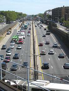
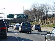
The expressway is one of the main routes for shipping and transportation through New York City due to its connections with New Jersey via the George Washington Bridge, Long Island via the Throgs Neck and Whitestone Bridges, Upstate New York via I-87 northbound and the Bronx River Parkway, Manhattan via I-87 southbound to the Robert F. Kennedy Bridge or the Trans-Manhattan Expressway (extension of the Cross Bronx Expressway westward) and the Henry Hudson Parkway, and New England via the New England Thruway (I-95) and the Hutchinson River Parkway. As such, the expressway is also known for its extreme traffic problems; on a typical day 175,000 vehicles travel on the six lanes of highway the road contains, and it is not uncommon for truckers to use the Cross-Westchester Expressway to the New York State Thruway and the Major Deegan Expressway to get around this stretch of I-95. Proposals have been made to add a second deck to the road, although to no avail.[21] In both 2008 and 2007, Inrix cited the Cross Bronx Expressway's westbound exit 4B (Bronx River Parkway) as being the worst intersection in the United States. In 2008, the expressway's exits included three out of the top four on the list, and four of the top five in 2007.[22]
Exit list
The entire route is in the New York City borough of The Bronx.
| Location | mi[1][2] | km | Exit | Destinations | Notes |
|---|---|---|---|---|---|
| Harlem River | 0.00 | 0.00 | – | Continuation into Manhattan via Trans-Manhattan Expressway | |
| Alexander Hamilton Bridge | |||||
| Morris Heights | 0.10– 0.60 | 0.16– 0.97 | 1 | Amsterdam Avenue (via Washington Bridge) | Signed as exit 1B; southbound exit and northbound entrance |
| Signed as exits 1C (south) and 1D (north) | |||||
| 0.80 | 1.29 | 2A | Jerome Avenue | ||
| Tunnel under Jennie Jerome Playground | |||||
| Tremont | 1.28 | 2.06 | 2B | US 1 leaves C.B.X.; eastbound exit and westbound entrance | |
| 1.86 | 2.99 | 3 | Westbound exit and eastbound entrance | ||
| West Farms | 2.05 | 3.30 | Tunnel under East 176th Street | ||
| 2.64 | 4.25 | 4A | Eastbound exit and westbound entrance | ||
| Soundview | 3.00 | 4.83 | 4B | No direct access to Bronx River Parkway south | |
| Parkchester | 3.70– 4.30 | 5.95– 6.92 | 5A | White Plains Road / Westchester Avenue | |
| 3.70– 3.80 | 5.95– 6.12 | Tunnel under Hugh J. Grant Circle | |||
| Castle Hill | 4.00 | 6.44 | 5B | Castle Hill Avenue | Eastbound exit and westbound entrance |
| Throggs Neck | 4.50 | 7.24 | 6A | Eastbound exit and westbound entrance; exit 19 on I-678 | |
| 4.70 | 7.56 | 6B | C.B.X. transitions from I-95 to I-295; eastbound exit and westbound entrance | ||
| 5.10– 5.30 | 8.21– 8.53 | 12 | Westbound exit and eastbound entrance; exit 54 on I-278 | ||
| 5.50– 6.00 | 8.85– 9.66 | 11 | Randall Avenue | ||
| 6.60 | 10.62 | 10 | Northbound exit and southbound entrance; south end of I-695 | ||
| 6.80 | 10.94 | 9 | Harding Avenue / Pennyfield Avenue | ||
| – | Continuation into Queens | ||||
1.000 mi = 1.609 km; 1.000 km = 0.621 mi
| |||||
See also
-
.svg.png) New York Roads portal
New York Roads portal
References
- 1 2 "2010 Traffic Volume Report for New York State" (PDF). New York State Department of Transportation. July 25, 2011. p. 151. Retrieved February 6, 2012.
- 1 2 Google (January 9, 2016). "Cross Bronx Expressway" (Map). Google Maps. Google. Retrieved January 9, 2016.
- 1 2 Ingraham, Joseph C. (November 4, 1955). "3 Highway Links Open Tomorrow". The New York Times. p. 4. Retrieved April 14, 2010.
- ↑ New York City Department of Transportation, Truck Routes, accessed November 2007: shows that the Cross Bronx Expressway Extension ends at the Throgs Neck Expressway, while the Throgs Neck Expressway continues to the Throgs Neck Bridge
- ↑ "Call Traffic Study City Planning Aid". The New York Times. October 29, 1929. p. 32. Retrieved April 14, 2010.
- ↑ Harland Bartholomew, Report to the Honorable James J. Walker, Mayor, on Highway Traffic Conditions and Proposed Traffic Relief Measures for the City of New York, Day & Zimmermann, 1929, OCLC 35914068
- ↑ New York City area (Map). H.M. Gousha Company. 1941. Retrieved February 6, 2012.
- ↑ "Pattern of Highways for the City as Proposed in Board's Master Plan". The New York Times. November 21, 1940. p. 39. Retrieved April 14, 2010.
- ↑ Ingraham, Joseph C. (January 1, 1961). "Around the Town: New York City's System of Bypasses Is Beginning to Take Shape". The New York Times. p. X17. Retrieved April 14, 2010.
- ↑ "Expressway Growing: Cross-Bronx Artery Will Be Extended a Mile Today". The New York Times. April 23, 1956. p. 29. Retrieved April 14, 2010.
- ↑ "Cross-Bronx Route to Add Section". The New York Times. April 25, 1960. p. 23. Retrieved April 14, 2010.
- ↑ "Cross Bronx Highway Link Ready". The New York Times. January 31, 1961. p. 13. Retrieved April 14, 2010.
- ↑ "New Bridge Completes L.I.-to-Jersey Bypass". The New York Times. April 14, 1963. p. 528. Retrieved April 14, 2010.
- ↑ Ingraham, Joseph C. (November 15, 1964). "New York Bypass: Narrows Bridge Adds More New Ways To Avoid City's Traffic Jams". The New York Times. p. XX1. Retrieved April 14, 2010.
- ↑ "Expressway Ramps Opening". The New York Times. November 19, 1964. p. 39. Retrieved April 14, 2010.
- ↑ Prial, Frank J. (December 21, 1972). "The Bruckner Interchange Open at Last". The New York Times. p. 40. Retrieved April 14, 2010.
- ↑ "Metropolitan Briefs". The New York Times. December 31, 1972. p. 36. Retrieved April 14, 2010.
- ↑ Rand McNally Road Atlas: United States, Canada and Mexico (Map). Rand McNally and Company. 1964.
- ↑ Caro, Robert A. (1974). The Power Broker: Robert Moses and the fall of New York. New York: Knopf. ISBN 0-394-48076-7.
- ↑ Ric Burns, New York: A Documentary Film, episode 7, The American Experience, PBS Television, WNET New York and WGBH Boston, 1999.
- ↑ Anderson, Steve. "Cross Bronx Expressway (I-95, I-295 and US 1)". NYCRoads. Retrieved February 6, 2012.
- ↑ Bruner, Jon (February 25, 2009). "America's Worst Intersections". Forbes. Retrieved March 1, 2009.
External links
-
 Media related to Cross Bronx Expressway at Wikimedia Commons