Cromer Street

Cromer Street is a road in King's Cross in central London, England. It starts in the west at Judd Street, then goes east, ending at Gray's Inn Road. It gave access from Gray's Inn Road to Greenland Place and a bowling green.
History
Cromer Street was formerly called Lucas Street and was renamed in 1818. In the earlier 1840s, it was described as being occupied by a class of poor 'small tradesmen and artisan lodgers' in densely crowded lodgings.[1] On it is Church of the Holy Cross, which was built by Joseph Peacock and dedicated in 1888.
105 houses were built in the street in the early 19th century, but it has largely been rebuilt and consists of over 1,000 council and housing properties, mostly pre-1919 railway tenements of fine architectural qualities on the north side, and on the south a "striking sequence of nine 6-storey slabs of flats of 1949 - 1951 by Hening & Chitty...They were singled out by Pevsner in 1952 as some of the first good post-war flats" The area has suffered deprivation and crime and[2] in 1996, was the subject of a £46 million regeneration project.[3]
Transport
The nearest tube stations are King's Cross St. Pancras, Russell Square, and Euston.
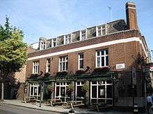
Pubs
The street contains two pubs: The Lucas Arms at the east end, on the junction with Gray's Inn Road, and The Boot at the west end, near the junction with Judd Street. The Boot Tavern was the headquarters of the Gordon rioters and later was mentioned in Charles Dickens' book, Barnaby Rudge; it was rebuilt in 1801.[4] The Lucas Arms has been used for meetings of political organisations.[5][6]
References
- Walter H. Godfrey and W. McB. Marcham, ed. (1952). Survey of London. vol. 24. London: Publisher: London County Council. pp. 94–95. Retrieved 28 January 2008.
- ↑ Thomas Wakley, ed. (1843). On the excess of diseases in large towns, and its causes. vol. 2. London: J. Onwhyn. p. 775. Retrieved 28 January 2008.
- ↑ The Buildings of England. London 4:North. Bridget Cherry and Nikolaus Pevsner. Yale University Press 2002
- ↑ Colquhoun, Ian (2003). Design out crime:creating safe and sustainable." communities. London: Architectural Press. p. 284. ISBN 978-0-7506-5492-0. Retrieved 28 January 2008.
- ↑ Alexander John Philip, William Laurence Gadd, ed. (1970). A Dickens Dictionary (2nd ed.). Ayer Publishing. p. 330. ISBN 978-0-8337-2735-0. Retrieved 28 January 2008.
- ↑ Fionnbarra Ó Dochartaigh. Ulster's White Negroes. p. 19.
- ↑ Muriel Seltman. What's Left? What's Right?: A Political Journey. p. 64.
Coordinates: 51°31′40″N 0°07′19″W / 51.52778°N 0.12194°W