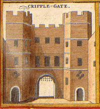
Cripplegate
| Ward of Cripplegate | |
 Ward of Cripplegate |
|
| Population | 2,782 (2011 Census. Ward)[1] |
|---|---|
| OS grid reference | TQ327811 |
| Sui generis | City of London |
| Administrative area | Greater London |
| Region | London |
| Country | England |
| Sovereign state | United Kingdom |
| Post town | LONDON |
| Postcode district | EC3 |
| Dialling code | 020 |
| Police | City of London |
| Fire | London |
| Ambulance | London |
| EU Parliament | London |
| UK Parliament | Cities of London and Westminster |
| London Assembly | City and East |
Coordinates: 51°31′08″N 0°05′38″W / 51.519°N 0.094°W
Cripplegate was a gate in the London Wall and a name for the region of the City of London outside the gate. The area was almost entirely destroyed in the Blitz of World War II and today it is the site of the Barbican Estate and Barbican Centre. The name is preserved in the church of St Giles-without-Cripplegate, in the Cripplegate ward of the City, and in a small road named Cripplegate Street which lies slightly to the north of the site of the Wall between Viscount Street and Bridgewater Street.[2]
The ward of Cripplegate straddles the former line of the Wall and the old gate, and remains[3] divided into "Within" and "Without" parts, with a beadle and a deputy (alderman) appointed for each part. Since the 1994 (City) and 2003 (ward) boundary changes, most of the ward is Without, with the ward of Bassishaw having expanded considerably into the Within area.
History
[4] In A.D. 1068 the only burial place in all England allowed to the Jews was in Cripplegate (where Jewin Street now stands), and Jews from all other parts of the country were forced, at enormous expense and inconvenience, to bring thither their dead.
In 1555, John Gresham endowed the new Gresham's School in Norfolk with three tenements in the parish of St. Giles Without Cripplegate, including 'The White Hind' and 'The Peacock'.[5]
During the Second World War the Cripplegate area, a centre of the rag trade,[6] was virtually destroyed and by 1951 the resident population of the City stood at only 5,324, of whom 48 lived in Cripplegate. Discussions began in 1952 about the future of the area, and the decision to build new residential properties was taken by the Court of Common Council on 19 September 1957. The area was reopened as the Barbican Estate in 1969. Cripplegate is today the most populous of the four residential wards of the City, with a population of 2,782 (2011).
Etymology
It is not certain what is the origin of the name.[7] One theory, bolstered by the gate's mentions in the fourth law code of Æthelred the Unready and a charter of William the Conqueror from 1068 under the name "Crepelgate",[8] is that it is named for the Anglo-Saxon word crepel, meaning for a covered or underground passageway.
Another unsubstantiated theory suggests it is so-called because of the cripples who used to beg there; the name of the nearby medieval church of St Giles-without-Cripplegate lends credence to this suggestion as Saint Giles is the patron saint of cripples and lepers.
Cripplegate ward

Cripplegate is one of the 25 ancient wards of the City of London, each electing an alderman to the Court of Aldermen and commoners (the City equivalent of a councillor) to the Court of Common Council of the City of London Corporation. Only electors who are Freemen of the City are eligible to stand. In the early 12th century, the area was originally referred to as Alwoldii which was probably the name of the current alderman.[9] The early records are unreliable as regards who the Aldermen were, but from 1286 there is a more reliable list of Aldermen available.[9]
In popular culture
The second wedding in the film Four Weddings and a Funeral takes place in the fictional church of St. Mary of the Fields, Cripplegate, EC2[10] It was filmed in the chapel of the Royal Naval College, Greenwich.[11]
See also
References
- ↑ "City of London Ward population 2011". Neighbourhood Statistics. Office for National Statistics. Retrieved 16 October 2016.
- ↑ A-Z London. Geographer's A-Z Map Co Ltd. 2001. p. 162. ISBN 0-85039-753-7.
- ↑ Cripplegate Ward News - note use of "Within" and "Without" on page 4
- ↑ Light for the last days (1888), H Grattan Guinness D.D., FRAS>
- ↑ Herbert, William, The History of the Twelve Great Livery Companies of London (London, Wm Herbert, 1836) pp. 80-81 at books.google.co.uk
- ↑ Tom Bolton (June 24, 2015). "From Cripplegate to Agar Town: inside London's vanished neighbourhoods". The Guardian. Retrieved June 24, 2015.
by the second world war, Cripplegate had become "Fire Island", the highest-insurance-risk area in London, occupied by rag trade warehouses packed with tinder-box stock.
- ↑ Harben, Henry (1918). A Dictionary of London. London.
- ↑ 'Saxon London', by Alan Vince, 1990, p43
- 1 2 Caroline Fiona Gordon (1985), The Ward of Cripplegate in the City of London, London: Cripplegate Ward Club
- ↑ Sic : Cripplegate is in the EC3 postcode area.
- ↑ Four Weddings and a Funeral at movie-locations.com
- Old and New London and A New History of London — two historical sources on the ward from British History Online
- Map of Early Modern London: Cripplegate Ward - Historical Map and Encyclopedia of Shakespeare's London(Scholarly)
External links
- Cripplegate Ward The Official Ward Website
- City of London Corporation Map of Cripplegate ward (2003 —)
- Cripplegate Ward Club - A Social Club based in the City of London
| Wards |  | |
|---|---|---|
| Enclaves | ||
| Localities | ||
| Attractions |
| |
| Notable structures | ||
| Civil parishes | ||
| Bridges | ||
| Rail and tube stations | ||
| Topics | ||
| ||
Gates and bars of the City of London | |||
|---|---|---|---|
 | Former gates of London Wall and City bars
Listed clockwise from the West
| ||