Craig y Llyn
- For the subsidiary summit of Cadair Idris see Craig-y-llyn.
| Craig y Llyn | |
|---|---|
 | |
| Highest point | |
| Elevation | 600 m (2,000 ft) |
| Prominence | 392 m (1,286 ft) |
| Listing | Marilyn, council top |
| Coordinates | 51°42′57″N 3°35′06″W / 51.71592°N 3.58497°WCoordinates: 51°42′57″N 3°35′06″W / 51.71592°N 3.58497°W |
| Naming | |
| Translation | cliff of the lake (Welsh) |
| Pronunciation | Welsh: [ˈkɾaiɡəɬɪn] |
| Geography | |
 Craig y Llyn | |
| OS grid | SN906031 |
| Topo map | OS Landranger 170 |
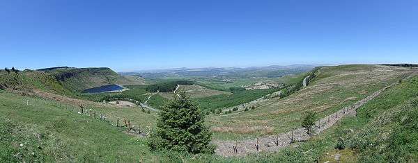
Craig y Llyn is a mountain situated in Rhigos on the west side of the upper Cynon Valley and north of the Rhondda Valleys in South Wales; it is the highest point in the traditional county of Glamorgan and the highest in the South Wales Valleys. It has been designated as a Site of Special Scientific Interest and is named from the cliffs of its steep northern escarpment which overlook Llyn Fawr.
Description
Craig y Llyn is situated in Rhigos, which lies in the Cynon Valley in the Rhondda Cynon Taff, Wales.
The hill is covered by forestry, except for the steep north and northeast faces, and is crowned with a trig point. Several footpaths cross near the summit of the hill, including the Coed Morgannwg Way, and the county boundary between Neath Port Talbot and Rhondda Cynon Taff passes 200 m to the east of the summit. The highest point in Rhondda Cynon Taff, Craig y Llyn, is commonly known as the Rhigos Mountain after the village of Rhigos located on the northern side of the mountain in the Cynon Valley.
The Countryside Council for Wales states that the site has been categorised as a Site of Special Interest because it supports "...two special habitat features, and is also of special interest for a plant, the Water Lobelia. The first habitat feature is standing water, supporting aquatic plants typical of lakes with low nutrient content. Some of these plants are not known from anywhere further south in the UK. The second is dry heath, found on the slopes above the lakes.[1]
Geology
The hill is composed of a thick sequence of sandstones and mudstones assigned to the South Wales Coal Measures. The summit plateau is formed from the Pennant Sandstone of the Upper Coal Measures. The two cwms on its northern flanks which shelter Llyn Fach and Llyn Fawr are of glacial origin. A landslipped mass of rock lies above the western end of the latter lake.[2]
References
- ↑ "Craig-y-Llyn". ccw.gov.uk. Archived from the original on 14 December 2014. Retrieved 30 October 2011.
- ↑ British Geological Survey 1:50,000 map sheet 231 'Merthyr Tydfil'