Cragsmoor, New York
| Cragsmoor, New York | |
|---|---|
| CDP | |
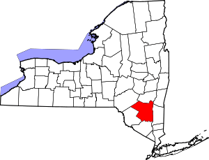
 Location in Ulster County and the state of New York. | |
| Coordinates: 41°40′6″N 74°23′17″W / 41.66833°N 74.38806°WCoordinates: 41°40′6″N 74°23′17″W / 41.66833°N 74.38806°W | |
| Country | United States |
| State | New York |
| County | Ulster |
| Area | |
| • Total | 4.4 sq mi (11.3 km2) |
| • Land | 4.4 sq mi (11.3 km2) |
| • Water | 0.0 sq mi (0.0 km2) |
| Elevation | 1,864 ft (568 m) |
| Population (2010) | |
| • Total | 449 |
| • Density | 108.5/sq mi (41.9/km2) |
| Time zone | Eastern (EST) (UTC-5) |
| • Summer (DST) | EDT (UTC-4) |
| ZIP code | 12420 |
| Area code(s) | 845 |
| FIPS code | 36-18762 |
| GNIS feature ID | 0947634 |
Cragsmoor is a hamlet (and census-designated place) in Ulster County, New York, United States. The population was 449 at the 2010 census.
Cragsmoor is located atop the Shawangunk Ridge, in the south part of the Town of Wawarsing. Sam's Point Preserve is near Cragsmoor.
History
Cragsmoor, originally named Evansville, was founded as an art colony in 1879, after being discovered by artists earlier in the decade. It was renamed to Cragsmoor in 1893.[1][2][3]
Chetolah and the Cragsmoor Historic District are listed on the National Register of Historic Places.[4]
Geography
According to the United States Census Bureau, the CDP has a total area of 4.4 square miles (11 km2), all land.
The center of town is about 1,800 feet (548.6 m) above sea level, much higher than neighboring communities such as Ellenville and Walker Valley.
As a whole, the hamlet has a wooded, rustic ambience. Most homes are rather modest and old, but sit on large lots with many tall shade trees. There are also many large undeveloped woodlots, and thus property values in Cragsmoor are higher than in the rest of Wawarsing. Other than the post office, there is no business district to speak of.
In 1996 the 3,620 acres (14.6 km2) comprising much of the hamlet's center were added to the National Register of Historic Places as the Cragsmoor Historic District, due to buildings designed by Bert Goldsmith and Frederick S. Dellenbaugh.
The Long Path hiking trail passes through the center of town on its way to Sam's Point.
Demographics
As of the census[5] of 2000, there were 474 people, 189 households, and 137 families residing in the CDP. The population density was 108.5 per square mile (41.9/km²). There were 257 housing units at an average density of 58.8/sq mi (22.7/km²). The racial makeup of the CDP was 94.09% White, 0.84% Native American, 1.48% from other races, and 3.59% from two or more races. Hispanic or Latino of any race were 4.85% of the population.
There were 189 households out of which 29.6% had children under the age of 18 living with them, 59.3% were married couples living together, 8.5% had a female householder with no husband present, and 27.5% were non-families. 20.1% of all households were made up of individuals and 9.0% had someone living alone who was 65 years of age or older. The average household size was 2.51 and the average family size was 2.92.
In the CDP the population was spread out with 23.2% under the age of 18, 5.5% from 18 to 24, 27.2% from 25 to 44, 31.6% from 45 to 64, and 12.4% who were 65 years of age or older. The median age was 40 years. For every 100 females there were 100.8 males. For every 100 females age 18 and over, there were 96.8 males.
The median income for a household in the CDP was $64,500, and the median income for a family was $56,250. Males had a median income of $42,250 versus $55,556 for females. The per capita income for the CDP was $22,712. About 9.4% of families and 11.1% of the population were below the poverty line, including 19.1% of those under age 18 and none of those age 65 or over.
Notable residents
- Edward Lamson Henry N.A., the painter of historical themes, lived in Cragsmoor and helped found an artist's colony.
- Dave Cockrum, X-Men illustrator lived here for much of the 1980s and 90s.[6]
References
- ↑ American Art Colonies, 1850-1930: A Historical Guide to America's Original ... - Steve Shipp - Google Boeken
- ↑ Underpaintings: Random Inspiration: Charles Courtney Curran (1861-1942)
- ↑ Re: Where is Evansville?
- ↑ National Park Service (2010-07-09). "National Register Information System". National Register of Historic Places. National Park Service.
- ↑ "American FactFinder". United States Census Bureau. Archived from the original on September 11, 2013. Retrieved 2008-01-31.
- ↑ Horrigan, Jeremiah; December 2, 2006; X-Men envisioner Dave Cockrum dies at 63; Times-Herald Record; retrieved December 3, 2006.

