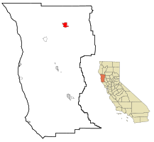
Covelo, California
| Covelo | |
|---|---|
| census-designated place | |
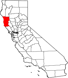
 Location in Mendocino County and the state of California | |
| Coordinates: 39°47′35″N 123°14′53″W / 39.79306°N 123.24806°WCoordinates: 39°47′35″N 123°14′53″W / 39.79306°N 123.24806°W | |
| Country |
|
| State |
|
| County | Mendocino |
| Area[1] | |
| • Total | 7.138 sq mi (18.489 km2) |
| • Land | 7.095 sq mi (18.377 km2) |
| • Water | 0.043 sq mi (0.112 km2) 0.60% |
| Elevation[2] | 1,398 ft (426 m) |
| Population (2010) | |
| • Total | 1,255 |
| • Density | 180/sq mi (68/km2) |
| Time zone | Pacific (PST) (UTC-8) |
| • Summer (DST) | PDT (UTC-7) |
| ZIP code | 95428 |
| Area code(s) | 707 |
| FIPS code | 06-16728 |
| GNIS feature ID | 0277603 |
Covelo is a census-designated place (CDP) in Mendocino County, California, United States. Covelo is located 14 miles (23 km) east-northeast of Laytonville,[3] at an elevation of 1398 feet (426 m).[2] The population was 1,255 at the 2010 census, up from 1,175 at the 2000 census.
Geography
Covelo is located at 39°47′35″N 123°14′53″W / 39.79306°N 123.24806°W.[2]
According to the United States Census Bureau, the CDP has a total area of 7.1 square miles (18 km2), 99.40% of it land, 0.60% of it water.
Covelo is the location of the Covelo American Viticultural Area.
Climate
According to the Köppen Climate Classification system, Covelo has a hot-summer Mediterranean climate, abbreviated "Csa" on climate maps.
| Climate data for Covelo (1894-2012) | |||||||||||||
|---|---|---|---|---|---|---|---|---|---|---|---|---|---|
| Month | Jan | Feb | Mar | Apr | May | Jun | Jul | Aug | Sep | Oct | Nov | Dec | Year |
| Record high °F (°C) | 78 (26) |
82 (28) |
88 (31) |
94 (34) |
104 (40) |
108 (42) |
114 (46) |
115 (46) |
114 (46) |
104 (40) |
88 (31) |
75 (24) |
115 (46) |
| Average high °F (°C) | 52.3 (11.3) |
57.4 (14.1) |
62.1 (16.7) |
68.2 (20.1) |
76.2 (24.6) |
84.6 (29.2) |
93.5 (34.2) |
92.7 (33.7) |
88.2 (31.2) |
75.5 (24.2) |
59.9 (15.5) |
51.7 (10.9) |
71.9 (22.2) |
| Average low °F (°C) | 30.4 (−0.9) |
32.7 (0.4) |
35.1 (1.7) |
37.4 (3) |
42 (6) |
47.2 (8.4) |
51.6 (10.9) |
49.6 (9.8) |
45 (7) |
39.1 (3.9) |
34.3 (1.3) |
31.8 (−0.1) |
39.7 (4.3) |
| Record low °F (°C) | 7 (−14) |
10 (−12) |
18 (−8) |
22 (−6) |
27 (−3) |
31 (−1) |
37 (3) |
37 (3) |
28 (−2) |
17 (−8) |
14 (−10) |
−9 (−23) |
−9 (−23) |
| Average precipitation inches (mm) | 8.18 (207.8) |
6.61 (167.9) |
5.56 (141.2) |
2.61 (66.3) |
1.36 (34.5) |
0.43 (10.9) |
0.05 (1.3) |
0.26 (6.6) |
0.55 (14) |
2.52 (64) |
5.6 (142) |
7.92 (201.2) |
41.66 (1,058.2) |
| Average snowfall inches (cm) | 2.1 (5.3) |
1 (3) |
0.8 (2) |
0.1 (0.3) |
0 (0) |
0 (0) |
0 (0) |
0 (0) |
0 (0) |
0 (0) |
0.2 (0.5) |
0.6 (1.5) |
4.7 (11.9) |
| Average precipitation days | 13 | 12 | 12 | 8 | 5 | 2 | 0 | 1 | 2 | 6 | 11 | 13 | 85 |
| Source: WRCC[4] | |||||||||||||
History
Covelo began in 1860, with the opening of the town's first store.[3] The post office opened in 1870.[3] Some sources claim that the town was named after a village in Switzerland.[3] However, there is no village in Switzerland by that name.[5] Covelo may be a misspelling of Covolo, a fort in Pederobba, Veneto, Italy, which is near Switzerland.[5]
Demographics
2010
The 2010 United States Census[6] reported that Covelo had a population of 1,255. The population density was 175.8 people per square mile (67.9/km²). The racial makeup of Covelo was 611 (48.7%) White, 14 (1.1%) African American, 475 (37.8%) Native American, 10 (0.8%) Asian, 0 (0.0%) Pacific Islander, 49 (3.9%) from other races, and 96 (7.6%) from two or more races. Hispanic or Latino of any race were 163 persons (13.0%).
The Census reported that 1,247 people (99.4% of the population) lived in households, 0 (0%) lived in non-institutionalized group quarters, and 8 (0.6%) were institutionalized.
There were 481 households, out of which 148 (30.8%) had children under the age of 18 living in them, 146 (30.4%) were opposite-sex married couples living together, 81 (16.8%) had a female householder with no husband present, 56 (11.6%) had a male householder with no wife present. There were 70 (14.6%) unmarried opposite-sex partnerships, and 0 (0%) same-sex married couples or partnerships. 148 households (30.8%) were made up of individuals and 53 (11.0%) had someone living alone who was 65 years of age or older. The average household size was 2.59. There were 283 families (58.8% of all households); the average family size was 3.25.
The population was spread out with 339 people (27.0%) under the age of 18, 105 people (8.4%) aged 18 to 24, 320 people (25.5%) aged 25 to 44, 299 people (23.8%) aged 45 to 64, and 192 people (15.3%) who were 65 years of age or older. The median age was 35.8 years. For every 100 females there were 97.3 males. For every 100 females age 18 and over, there were 99.6 males.
There were 542 housing units at an average density of 75.9 per square mile (29.3/km²), of which 314 (65.3%) were owner-occupied, and 167 (34.7%) were occupied by renters. The homeowner vacancy rate was 2.2%; the rental vacancy rate was 3.4%. 791 people (63.0% of the population) lived in owner-occupied housing units and 456 people (36.3%) lived in rental housing units.
2000
As of the census[7] of 2000, there were 1,175 people, 442 households, and 301 families residing in the CDP. The population density was 164.9 people per square mile (63.6/km²). There were 512 housing units at an average density of 71.8 per square mile (27.7/km²). The racial makeup of the CDP was 50.21% White, 0.85% Black or African American, 40.26% Native American, 0.34% Asian, 0.17% Pacific Islander, 1.96% from other races, and 6.21% from two or more races. 8.09% of the population were Hispanic or Latino of any race.
There were 442 households out of which 29.4% had children under the age of 18 living with them, 43.2% were married couples living together, 20.1% had a female householder with no husband present, and 31.7% were non-families. 26.0% of all households were made up of individuals and 7.5% had someone living alone who was 65 years of age or older. The average household size was 2.66 and the average family size was 3.17.
In the CDP the population was spread out with 28.9% under the age of 18, 8.9% from 18 to 24, 23.1% from 25 to 44, 27.1% from 45 to 64, and 12.2% who were 65 years of age or older. The median age was 36 years. For every 100 females there were 92.9 males. For every 100 females age 18 and over, there were 90.4 males.
The median income for a household in the CDP was $27,639, and the median income for a family was $31,875. Males had a median income of $21,146 versus $17,014 for females. The per capita income for the CDP was $12,628. About 17.1% of families and 27.1% of the population were below the poverty line, including 36.4% of those under age 18 and 10.8% of those age 65 or over.
Politics
In the state legislature, Covelo is in the 2nd Senate District, represented by Democrat Mike McGuire,[8] and the 2nd Assembly District, represented by Democrat Jim Wood.[9]
Federally, Covelo is in California's 2nd congressional district, represented by Democrat Jared Huffman.[10]
Notable people
- Michelle Lambert, pop singer, was born and raised in Covelo, CA.
References
- ↑ U.S. Census Archived 2012-01-24 at WebCite
- 1 2 3 U.S. Geological Survey Geographic Names Information System: Covelo, California
- 1 2 3 4 Durham, David L. (1998). California's Geographic Names: A Gazetteer of Historic and Modern Names of the State. Clovis, Calif.: Word Dancer Press. p. 43. ISBN 1-884995-14-4.
- ↑ "COVELO, CA (042081)". Western Regional Climate Center. Retrieved November 29, 2015.
- 1 2 Gudde, Erwin G. (1949). California Place Names: a Geographical Dictionary. Berkeley: University of California Press. p. 78.
- ↑ "2010 Census Interactive Population Search: CA - Covelo CDP". U.S. Census Bureau. Retrieved July 12, 2014.
- ↑ "American FactFinder". United States Census Bureau. Archived from the original on September 11, 2013. Retrieved 2008-01-31.
- ↑ "Senators". State of California. Retrieved March 10, 2013.
- ↑ "Members Assembly". State of California. Retrieved March 2, 2013.
- ↑ "California's 2nd Congressional District - Representatives & District Map". Civic Impulse, LLC. Retrieved March 1, 2013.