Courry
| Courry | |
|---|---|
|
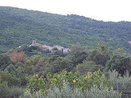
A general view of Courry | |
 Courry | |
|
Location within Occitanie region  Courry | |
| Coordinates: 44°18′00″N 4°09′23″E / 44.3°N 4.1564°ECoordinates: 44°18′00″N 4°09′23″E / 44.3°N 4.1564°E | |
| Country | France |
| Region | Occitanie |
| Department | Gard |
| Arrondissement | Alès |
| Canton | Saint-Ambroix |
| Intercommunality | Ranc d'Uzège |
| Government | |
| • Mayor (2008–2014) | Denise Cesco |
| Area1 | 8.22 km2 (3.17 sq mi) |
| Population (2008)2 | 313 |
| • Density | 38/km2 (99/sq mi) |
| Time zone | CET (UTC+1) |
| • Summer (DST) | CEST (UTC+2) |
| INSEE/Postal code | 30097 / 30500 |
| Elevation |
198–516 m (650–1,693 ft) (avg. 347 m or 1,138 ft) |
|
1 French Land Register data, which excludes lakes, ponds, glaciers > 1 km² (0.386 sq mi or 247 acres) and river estuaries. 2 Population without double counting: residents of multiple communes (e.g., students and military personnel) only counted once. | |
Courry is a commune in the Gard department in southern France.
Population
| Historical population | ||
|---|---|---|
| Year | Pop. | ±% |
| 1793 | 478 | — |
| 1821 | 525 | +9.8% |
| 1846 | 607 | +15.6% |
| 1872 | 649 | +6.9% |
| 1901 | 564 | −13.1% |
| 1926 | 411 | −27.1% |
| 1946 | 238 | −42.1% |
| 1962 | 230 | −3.4% |
| 1968 | 202 | −12.2% |
| 1975 | 179 | −11.4% |
| 1982 | 212 | +18.4% |
| 1990 | 218 | +2.8% |
| 1999 | 254 | +16.5% |
| 2008 | 313 | +23.2% |
See also
References
| Wikimedia Commons has media related to Courry. |
This article is issued from Wikipedia - version of the 11/7/2016. The text is available under the Creative Commons Attribution/Share Alike but additional terms may apply for the media files.