County Farm Bridge (Wilton, New Hampshire)
|
County Farm Bridge | |
 | |
  | |
| Nearest city | Wilton, New Hampshire |
|---|---|
| Coordinates | 42°51′25″N 71°49′3″W / 42.85694°N 71.81750°WCoordinates: 42°51′25″N 71°49′3″W / 42.85694°N 71.81750°W |
| Area | less than one acre |
| Built | 1885 |
| Architect | Ward Bros. |
| NRHP Reference # | 81000070[1] |
| Added to NRHP | May 14, 1981 |
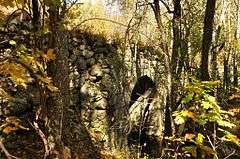
The County Farm Bridge is a historic stone arch bridge in Wilton, New Hampshire. Built in 1885, it carries Old County Farm over Whiting Brook, just south of its northern junction with Burton Highway in a rural section of northwestern Wilton. Old County Farm Road was the main access road to the Hillsborough County Poor Farm, and is now an unmaintained class 6 road. The bridge consists of a single stone arch with a span just under 18 feet (5.5 m). It is lined with cut granite voussoirs which were quarried in Wilton. The arch begins on land 7 feet (2.1 m) above the water, and the arch rises to a height of 15'10" above the typical water level. The arch is embedded in a causeway which is 430 feet (130 m) long.[2]
The bridge was listed on the National Register of Historic Places in 1981.[1]
See also
- National Register of Historic Places listings in Hillsborough County, New Hampshire
- List of bridges on the National Register of Historic Places in New Hampshire
References
- 1 2 National Park Service (2009-03-13). "National Register Information System". National Register of Historic Places. National Park Service.
- ↑ "NRHP nomination for County Farm Bridge" (PDF). National Park Service. Retrieved 2014-05-13.
| Topics | 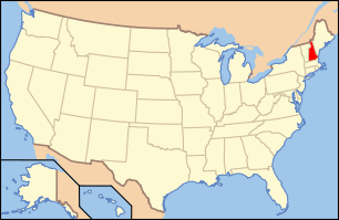 | |
|---|---|---|
| Lists by county | ||
| Other lists | ||
| ||