Countess Wear

Countess Wear, alternatively called Countess Weir, is a district within the city of Exeter, Devon, on the north bank of the River Exe.
History
The name derives from the weir constructed in 1286 on the instruction of Isabella de Fortibus, Countess of Devon.[1] Isabella was recorded as being heavily involved in numerous civil and criminal cases, with a good knowledge of laws as documented in the Statutes of the Realm, and it is possible that "Countess Wear" was a pun on her demanding behaviour.[2]
The Countess also constructed a corn mill in the area in 1284. It was rebuilt as a paper mill in 1658; the mill was destroyed by fire in the early 19th century, but was restored and continued operation until 1885. The remains of the building are still standing.[3]
Countess Wear was used as a US Navy base during World War II. Following the war, accommodation at the base was converted into temporary housing for people in Exeter whose homes had been damaged or destroyed.[4]
Transport
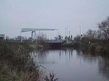
Countess Wear lends its name to a nearby set of bridges across the River Exe and the Exeter Canal. The first bridge was built in 1774 and was originally tolled, charging 1 penny for foot traffic and 1 shilling for a coach and six horses.[3] It had six arches, with the third being significantly wider than the others to allow ships to pass through.[5]
In 1935, the bridges were reconstructed for motor traffic as part of a bypass around Exeter, which had become increasingly congested as a bottleneck for holiday traffic heading to southwest England. The river bridge was widened from 13 feet 7 inches (4.14 m) to 45 feet (14 m) to allow two-way traffic with a pair of footpaths.[5] This bridge was Grade II listed in 2004.[6] The canal was crossed by a new electric swing bridge. The new bridges were opened by the Minister of Transport, Leslie Burgin on 22 February 1938 at a total cost of £230,000.[7]
In World War II, the canal bridge was used for rehearsing a glider attack on the Pegasus and Horsa Bridges in Normandy by the Oxfordshire and Buckinghamshire Light Infantry. A plaque was installed on the bridge in 1994, commemorating this event.[6] A bascule bridge was built alongside the swing bridge to increase traffic flow in 1972.[6]
Although the new bridges greatly improved traffic flow, by the 1970s they were inadequate for modern-day traffic requirements, leading to the parallel M5 motorway being constructed downstream. The replacement motorway was opened by the Prime Minister, James Callaghan in May 1977.[8]
At the centre of the area is the Countess Wear roundabout, where the old Exeter Bypass meets the crossroads for the Topsham Road.[9]
Education
There are three schools in the area:
- Countess Wear Community School[10]
- Southbrook School[11]
- The West of England School for the Partially Sighted
There is one church in the area:
- St Luke's Church (1837–38), Countess Wear Road.
References
Citations
- ↑ David Kemp, ed. (1992). The Pleasures and Treasures of Britain: A Discerning Traveller's Companion. Dundurn. p. 35. ISBN 978-1-554-88347-9.
- ↑ Bradt & Booth 2016, p. 53.
- 1 2 Bradt & Booth 2016, p. 52.
- ↑ "Huts (U.S. Naval Base, Exeter)". Hansard. 1 November 1945. Retrieved 15 August 2016.
- 1 2 "A New Road to the West". The Times. 17 September 1935. p. 16. Retrieved 15 August 2016. (subscription required (help)).
- 1 2 3 "The changing face of Bridge Road in Exeter". Devon County Council. 24 March 2016. Retrieved 15 August 2016.
- ↑ "Exeter By-Pass completed". The Times. 21 February 1938. p. 8. Retrieved 15 August 2016. (subscription required (help)).
- ↑ "M5 Exminster Section (J30 to J31)". Motorway Archive. Retrieved 15 August 2016.
- ↑ "Countess Wear Roundabout". Google Maps. Retrieved 15 August 2016.
- ↑ Countess Wear Community School website
- ↑ Southbrook School website
Sources
- Bradt, Hilary; Booth, Janice (2016). Slow Travel East Devon & The Jurassic Coast. Bradt Travel Guides. ISBN 978-1-784-77005-1.
| Wikimedia Commons has media related to Countess Wear bridges. |
Coordinates: 50°42′01″N 3°29′36″W / 50.70028°N 3.49333°W