Coulman Island
 | |
 Coulman Island Location in Antarctica | |
| Geography | |
|---|---|
| Location | Antarctica |
| Coordinates | 73°29′S 169°45′E / 73.483°S 169.750°ECoordinates: 73°29′S 169°45′E / 73.483°S 169.750°E |
| Length | 33.3 km (20.69 mi) |
| Width | 14.8 km (9.2 mi) |
| Highest elevation | 1,998 m (6,555 ft) |
| Administration | |
|
None | |
| Demographics | |
| Population | Uninhabited |
| Additional information | |
| Administered under the Antarctic Treaty System | |
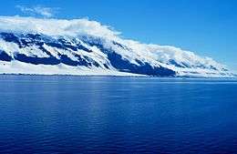
Coulman Island is an ice-covered island, composed of several connected shield volcanos in the Ross Sea off Antarctica. It is 33.3 kilometres (18 nmi) long and 14.8 kilometres (8 nmi) and is located 17 kilometres (9 nmi) SE of Cape Jones, Victoria Land. The Coulman caldera, 4.8 kilometres (3 mi) wide and 701 metres (2,300 ft) deep, can be found on the south end of the island. Emperor penguins inhabit this island. Coulman Island lies within the boundaries of Ross Dependency, which is claimed by New Zealand; a claim unrecognised by most other states. It was discovered in 1841 by Sir James Clark Ross who named it for his father-in-law, Thomas Coulman.[1] A notable landmark of this island is Cape Anne, the south-easternmost point of the island, so named by Sir James Clark Ross for his wife. Cape Wadworth is the northernmost point of the island.
The island has an elevation of 1,998 metres (6,555 ft).

See also
- Composite Antarctic Gazetteer
- List of Antarctic islands south of 60° S
- List of volcanoes in Antarctica
- Scientific Committee on Antarctic Research (SCAR)
- Territorial claims in Antarctica
References
External links
![]() This article incorporates public domain material from the United States Geological Survey document "Coulman Island" (content from the Geographic Names Information System).
This article incorporates public domain material from the United States Geological Survey document "Coulman Island" (content from the Geographic Names Information System).