Cotter Dam
| Cotter Dam | |
|---|---|
|
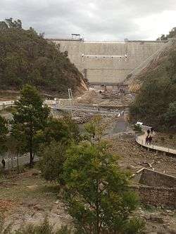
Cotter Dam, 2013 | |
 Location of the Cotter Dam in the ACT | |
| Location | Australian Capital Territory, Australia |
| Coordinates | 35°19′10″S 148°56′19″E / 35.31955°S 148.93853°ECoordinates: 35°19′10″S 148°56′19″E / 35.31955°S 148.93853°E |
| Purpose | Potable water supply |
| Status | Operational |
| Opening date | 1912; 2013 |
| Owner(s) | ACTEW Corporation |
| Dam and spillways | |
| Type of dam | Gravity dam |
| Impounds | Cotter River |
| Height | 87 m (285 ft) |
| Length | 330 m (1,080 ft) |
| Dam volume | 380×103 m3 (13×106 cu ft) |
| Spillways | 1 |
| Spillway type | Uncontrolled |
| Spillway capacity | 5,670 m3/s (200,000 cu ft/s) |
| Reservoir | |
| Creates | Cotter Reservoir |
| Total capacity | 78 GL (1.7×10¹⁰ imp gal; 2.1×10¹⁰ US gal) |
| Catchment area | 482 ha (1,190 acres) |
| Surface area | 285 ha (700 acres) |
| Normal elevation | 551 m (1,808 ft) |
|
Website Cotter Dam at ACTEW Water | |
The Cotter Dam is a concrete gravity and rockfill embankment dam across the Cotter River, located in the Australian Capital Territory, Australia. The impounded reservoir is called the Cotter Reservoir which is a supply source of potable water for the city of Canberra and its environs.
Original dam completed in 1912
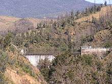
The original concrete gravity Cotter Dam was built in 1912 when the city of Canberra was established. The height of the dam wall was raised to a height of 31 metres (102 ft) in 1951 in order to increase capacity of the reservoir. The 26-thousand-cubic-metre (920×103 cu ft) dam wall was 118 metres (387 ft) long and created a reservoir with a surface area of 500 thousand cubic metres (18×106 cu ft). The uncontrolled spillway was capable of discharging 850 cubic metres per second (30,000 cu ft/s). At that time, the top water level of the dam was 501 metres (1,644 ft) above sea level and the reservoir had a capacity of 3,856 megalitres (848,000,000 imp gal; 1.019×10⁹ US gal).[1] A subsequent review in October 2006, using more accurate mapping methods, resulted in capacity being re-estimated downwards from the previous estimate of 4,700 megalitres (1.0×10⁹ imp gal; 1.2×10⁹ US gal). Additional galleries and drains were constructed between 1984 and 1986.[1] In order to supply the city with potable water, water from the reservoir was pumped to Mount Stromlo, and from there the water flowed by gravity to fill the city's reservoirs.
The dam water quality had deteriorated compared with Bendora and Corin dams and the dam was only used when water is in short supply. However, in December 2004, ACTEW Corporation brought the dam back on line in response to the ongoing drought.[2]
Enlarged dam completed in 2013
Completed in 2013, the enlarged Cotter Dam comprises a new 87-metre (285 ft) high concrete dam wall built downstream from the old 26-metre (85 ft) high dam wall, along with two auxiliary embankment dam walls along low-lying adjoining valleys. Constructed on rock foundations by Abigroup–John Holland joint venture, with engineering design by GHD, the main dam wall is 330 metres (1,080 ft) long, with the two rockfill embankments 340 metres (1,120 ft) and 300 metres (980 ft) long and 15 metres (49 ft) and 18 metres (59 ft) high respectively, both with internal earthen cores.[1] The enlarged dam walls increased the storage capacity of the Cotter Reservoir from the previous 3.9 gigalitres (860,000,000 imp gal; 1.0×10⁹ US gal) to 78 gigalitres (1.7×10¹⁰ imp gal; 2.1×10¹⁰ US gal);[3] while the catchment area remains 482 hectares (1,190 acres).[1]
The old dam wall remains, inundated by the water held behind the new dam wall and acting as a sediment trap for the new dam's intake tower. The old dam may only be visible in exceptional circumstances of drought. Completion was originally scheduled for the end of June 2011,[4] however construction was delayed until August 2013[5] due to heavy rainfalls in the summer of 2010/2011,[6] the discovery of an unexpectedly large rock seam at the site of the foundations in 2011,[7] and severe flooding in March 2012.[8] The uncontrolled spillway is capable of discharging 5,670 cubic metres per second (200,000 cu ft/s) from the 285-hectare (700-acre) Cotter Reservoir,[1] with a high water level approximately 551 metres (1,808 ft) above sea level.[2]

See also
References
- 1 2 3 4 5 "Register of Large Dams in Australia" (Excel (requires download)). Dams information. Australian National Committee on Large Dams. 2010. Retrieved 4 April 2014.
- 1 2 "Cotter Dam". ACTEW Water. ACTEW Corporation. 2011. Archived from the original on 14 April 2014. Retrieved 4 April 2014.
- ↑ "Enlarged Cotter Dam". ActewAGL. Retrieved 20 October 2013.
- ↑ "Enlargement of the Cotter Reservoir - Development application". ACTEW Corporation. July 2009. Retrieved 4 January 2013.
- ↑ "$405m dam operational, but more work to be done". The Canberra Times. Retrieved 6 September 2013.
- ↑ "Rain delays Enlarged Cotter Dam by three months" (Press release). ACTEW Corporation. 14 February 2011. Retrieved 4 April 2014.
- ↑ "Enlarged Cotter Dam construction and schedule update". ACTEW Corporation. Retrieved 4 January 2013.
- ↑ Kretowicz, Ewa; Downie, Graham (2 March 2012). "Cotter spills as deluge hits region". The Canberra Times. Retrieved 13 February 2013.
External links
![]() Media related to Cotter Dam at Wikimedia Commons
Media related to Cotter Dam at Wikimedia Commons
- "ACT Water Supply" (Interactive map). ACTEW Water. 2011.
- The Cotter Heritage Story
- Official Cotter Dam Time Lapse on YouTube
Rivers, other watercourses, reservoirs, river islands and waterfalls of the Australian Capital Territory | |
|---|---|
| Rivers and creeks |
|
| Reservoirs | |
| River islands | |
| Waterfalls |
|
| |