Cotgrave
| Cotgrave | |
 The Cross |
|
 Cotgrave |
|
| Population | 7,203 (2011) |
|---|---|
| OS grid reference | SK6435 |
| District | Rushcliffe |
| Shire county | Nottinghamshire |
| Region | East Midlands |
| Country | England |
| Sovereign state | United Kingdom |
| Post town | NOTTINGHAM |
| Postcode district | NG12 |
| Dialling code | 0115 |
| Police | Nottinghamshire |
| Fire | Nottinghamshire |
| Ambulance | East Midlands |
| EU Parliament | East Midlands |
| UK Parliament | Rushcliffe |
|
|
Coordinates: 52°55′N 1°02′W / 52.91°N 1.04°W
Cotgrave is a town and civil parish in the borough of Rushcliffe in Nottinghamshire, England, about 5 miles (8 km) south-east of the centre of Nottingham. The village sits at the edge of the South Nottinghamshire Wolds about 131 feet (40 metres) above sea level. Cotgrave's 2001 population of 7,373 people fell to 7,203 at the 2011 Census, even when Owthorpe was included.[1]
Position
With an ancient heart that has largely escaped development, Cotgrave still has a village atmosphere despite its population. This is accented by its amenities and infrastructure, which have remained comparatively underdeveloped, even though large housing estates were built round the village in the 1960s for people working for the coalmine. It is sandwiched between the A52, A606 and A46. To the west are Tollerton and Nottingham Airport, which has facilities for private planes and flight instruction.
History
Cotgrave's origins may be in the Iron Age. A 6th-century Anglo-Saxon burial ground has been excavated at Mill Hill to the north of the old village. There was certainly a Saxon church a century before the Norman Conquest. The Roman Fosse Way passes a mile to the east, where it changes direction slightly. The A46 follows its course, and during improvements in 2012–13, excavations uncovered Ice Age flint tools. Evidence of an Iron Age settlement was also found at Owthorpe Junction, just to the east, and a 4,000-year-old Neolithic circular monument with eight Bronze Age burials emerged slightly further north at Stragglethorpe junction.[2]
The place-name Cotgrave seems to contain an Old English personal name, Cotta, + grāf (Old English), grove or copse..so 'Cotta's grove'.[3]
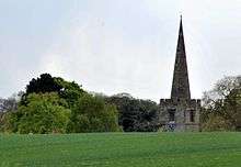
The present substantial church, All Saints', dates from the 12th century, with several subsequent alterations and additions. An arson attack in 1996 caused considerable damage, but the church has since been fully restored at great expense. The church has a ring of eight bells, most made by Taylor's.[4] A team of ringers practise regularly on Fridays and Sundays.
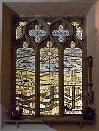
An outbreak of plague in 1637 killed 93 of a population of 500, including 46 children. All Saints' was used as a food store for the village during the outbreak. Money to pay for goods was disinfected as it was passed through a hollowed stone filled with vinegar to the men who had locked themselves away in the church. This stone is still in the church.[5] On Scrimshire Lane, near the church, can be found an old wall, dubbed the "Thousand-Year Wall". It is riddled with small holes made by, and providing a home for a large group of solitary bees. Nearby, through a lych gate, is a graveyard that is, unusually, separated from the church by a road. There can be found there a pillar on three tiers commemorating those of the village lost in service during the world wars. The church has a stained glass window, by J.F. Gascoyne & Son of Nottingham, dedicated in 1920 as a war memorial. There is also a window on the north aisle, east of the north door, depicting the koepe towers and underground workings of Cotgrave Colliery, which was sunk in the 1960s and abandoned in the 1980s. The window was installed after the fire at the church in 1996.
Memorials
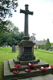
Cotgrave has a war memorial sited in the graveyard at Scrimshaw Lane to the west of All Saints. It commemorates the fallen of both world wars. The War Memorials Trust has helped towards the upkeep of this.[6]
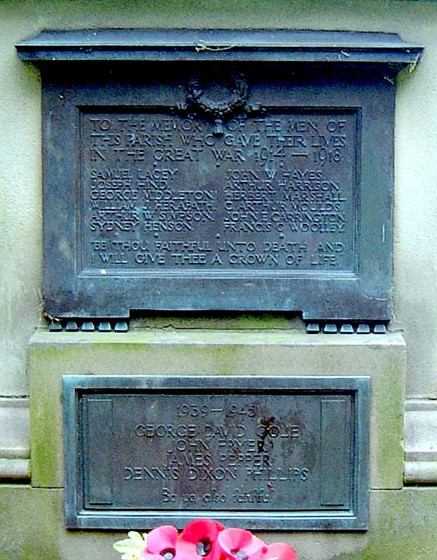
Twelve men from the First World War are listed above four from the Second World War on two metal panels on the east face of the memorial. The south face (presumably added at a later date as there was no room on the east face), names Walter Henstock, died 1920. An active British Legion group that includes nearby villages is marking the four-year centenary of the Great War by researching the men from the villages who gave their lives. Details of the Colston Bassett, Owthorpe and Cotgrave Great War Project, as far as they can be traced so far, appear on its website.[7]
The surnames of those noted lost in the First World War are Lacey, Hind, Middleton, Herapath, Simpson, Henson, Hayes, Harrison, Marshall, Moulds, Carrington, Woolley, Henstock. Those from the Second World War; Cole, Pryor, Pepper, Phillips. The epitaph reads: "Be thou faithful into death and I will give you a crown of life."[8]

The epitaph is often referred to as the Cotgrave Cross, as is the six-foot-high monument at the east end of the church. With later, partly ashlar construction parts from the 20th century and parts from the 16th,[9] it is somewhat of a mystery, as it is thought of as ancient, yet does not appear on photographs or pictures prior to the early 20th century. The site is near an important old junction, but there is no surviving medieval stonework evident. There were for some time thoughts that the war memorial should be moved to that site and the Cross moved perhaps to the country park,[10] but this was dismissed as costly.
There is a further memorial plaque, carved in oak, displayed to the right of the north door in All Saints' and a commemorative stained glass window to the east of the south aisle.
To the north at Cotgrave Place, near the golf course, there is a memorial to a Vickers Wellington bomber that crashed on 8 February 1941. The aircraft, from No. 12 Squadron, recently dispersed from RAF Station Binbrook to nearby RAF Station Tollerton, was on a gunnery training flight when the pilot encountered control problems. The aircraft hit an oak tree, just short of the still existing runway, next to where the golf club house now stands. A plaque nearby commemorates seven of the crew on board who were killed.[11]
Past notables
Ernest Hayes, born 1898 in Gripps Cottage, Cotgrave. He went on to join the British Army Kings Own Yorkshire Light Infantry in 1916 and was awarded the Military Medal three times for bravery on the Western Front (France) in 1918. He died in Nottingham in 1938.
Frank Robinson (1932–4 July 2004) lived in Cotgrave and travelled to Nottingham daily where, around Lister Gate, he entertained passers-by on a child's five-note glockenspiel. On his death hundreds of tributes were received from Nottingham's citizens.[12]
Nathan Robertson, World Badminton Champion (2006), Olympic Silver Medallist (2004), Commonwealth Games 2010 Mixed Doubles Silver Medallist[13] grew up in Cotgrave and attended the village school.
Cotgrave Colliery

The town lies on the Grantham Canal, opened in 1797. Some exploration for coal had been attempted for a hundred years but none was discovered in the area until about 1950. Cotgrave Colliery was established in the early 1960s with large numbers of miners and their families being moved from other mining areas of England, especially the North East, to live on a large purpose-built housing estate. Initially, in 1962, around 500 experienced mining workers and their families, accepted the National Coal Board incentive of tied new houses complete with furnishings to move from the area of the recently closed Radford Mine on the north-west side of nearby Nottingham. This mine was near the site of what is now known as Bobber's Mill. Some four years later a similar scheme was introduced to attract miners from other worked-out mines in the North East of England, including Gateshead. It is interesting to note that, according to residents, special meetings were arranged so that workers already established could understand, for safety reasons, the dialect, and vice versa, of the newcomers. The population of the village rose from about 700 to over 5,000 within a few years. A branch railway was extended from Nottingham over the River Trent past Radcliffe on Trent to service the colliery. The koepe towers at the pit head were considered very modern and distinctive compared with other pit-head winding gear towers.[14] In a departure from traditional miners' working conditions, face workers had extensive modern changing and shower facilities, which meant they could leave as clean as they entered.
The local economy was devastated by the mine's closure in 1993–94, which caused much bitterness. Like most Nottinghamshire mines, Cotgrave had continued working through the National Union of Mineworkers-declared 1984–85 miners' strike. Many took the view that this allegiance to the then Conservative government was betrayed. On its closure, it was reported that the seams had millions of tons of coal reserves but these were of insufficient quality.[15] Local residents, however, recount that the mine was shut because of geological faults, the encounter of a subterranean stream and subsequent flood problems, and the growing remoteness of the seam face from the shaft, which drastically increased the cost of bringing the coal to the surface. The shafts were filled with concrete on closure and all associated buildings demolished.
The local economy has improved considerably as Cotgrave is surrounded by an affluent area with low unemployment. Many of the mineworkers who hailed from the North East stayed in Cotgrave, built homes and raised families.
Amenities
There is a small shopping parade called the precinct, built at the same time as the large housing estates were developed, with a Co-op, a library, fish and chip shop, Chinese and kebab take-aways, other retailers. and a medical centre. The precinct is overdue for development and there are plans for this linked to the building of new homes on the nearby pit site.[16]
The Church of England church is All Saints,[17] on Plumtree Road. There is also has a Methodist chapel,[18] dating from 1802 and a Roman Catholic church, (Our Lady of Grace[19]). The Cross is a local booklet produced monthly by the Anglican church.[20]
Near the parish church is a small Sainsbury's Local store, and adjacent to that, Grannie's Tea Rooms. The leisure centre has a large swimming pool, gymnasium and sports hall with playing fields. There are two allotment areas, off Burrhill and Forest Close.

There are two primary schools: Cotgrave Candleby Lane School and Cotgrave Church of England (Aided) Primary School. The latter first opened in 1720, and moved to the present building, built by Earl Manvers, in 1863.[21]
Nearby is Cotgrave Futures, with Sure Start and meeting facilities. There are two pubs: the Manvers Arms, named after the Manvers family,[22] which owned much of the land in the area, and the Rose and Crown towards the north of the village. A third pub, the Black Diamond, was built in the 1960s but closed in 2006, demolished and replaced with housing.
Community

Across the road from the leisure centre is Cotgrave Club. The Miners' Welfare Club was built in the early 1960s. An unremarkable building at first sight but of prodigious size, it boasts several large bars, a garden, family and snooker rooms, entertainment suites with their own bars, and one of the largest fully equipped stages in the East Midlands. The main hall can seat several hundred people and has two dedicated large bars, a food bar and a gallery. The various rooms and hall are available to hire for weddings, funerals, parties, plays, pantomimes and other productions needing facilities for large audiences and refreshments.
The club has a cricket and football team with grounds enough to field two football matches. There are large changing rooms and pavilion facilities for home and visiting teams. In 2012 the club hosted the Cotgrave Festival of Sports, a variety of sporting events through the last week in June, culminating in a finale day of presentations and entertainment. Involving all the schools and community, this was repeated in 2013–14 and is intended to continue annually.[23]
At the end of 2011 the people of Cotgrave launched Cotgrave Community Website.[24] This forum is paid for by the council but run by the council and local residents. Members are registered with their real names and checked on the electoral roll.
Country park

The extensive former mining area has been landscaped to form a country park. Here a long section of the Grantham Canal has been partially restored, including at least two locks. This is not presently navigable, but nearby road bridges have been removed. though in other areas of the Grantham Canal some bridges have been rebuilt to accommodate canal traffic.[25] Plans to put the canal back to water were gradually taking shape, and as a brownfield site in a rural area, the old pit-head area would prove an ideal one for the building of a marina. This pit-head area is cordoned off from public and there are plans for redevelopment, on which (as of May 2010) there was to be public discussion. Plans to build around 470 houses on the site would impact the infrastructure and the ongoing development of the young country park.
Planted woodland is now beginning to mature and the country park is gradually acquiring a diverse population of wildlife. Wildfowl abound, with reports of cuckoos, warblers, swallows, little ringed plover, yellow wagtail, ring ouzel, wheatear, chiffchaff and dabchicks. Great crested newts are reported to be established in the lake, and hares, rabbits, foxes, bats and owls are present. The lake, pictured, is well stocked and used by anglers regularly. Fishing platforms have been built around the lake and reed beds established to protect the breeding waterfowl, including a variety of ducks, coots, swans and heron.
The park has a picnic area, easily accessible car parks, a gallop for horse riders and a well-marked nature trail. This features woodland, lake and canal side walks, as well as taking a route along the old railway track, where a short portion of the original rails and sleepers have been left in place. A group called Friends of Cotgrave Country Park works to maintain and improve the facilities at the park, and meets regularly in Cotgrave. Details of how to become involved can be found on the Rushcliffe Council website.[26] The group in 2010–12 helped to plan and build a swimming pool for dogs, away from the vulnerable wildlife in the country park's lake.
References
- ↑ "Town population 2011". Neighbourhood Statistics. Office for National Statistics. Retrieved 6 April 2016.
- ↑
- ↑ J. Gover, A. Mawer & F. M. Stenton (eds.), Place Names of Nottinghamshire (Cambridge, 1940), p.233; A.D.Mills, Dictionary of English Place-Names (Oxford, 2002), p.133; E .Ekwall, Concise Oxford Dictionary of English Place-names (Oxford, 1960), p.124; V.Watts, Cambridge dictionary of English place-names, (Cambridge,2004), p.160
- ↑ http://southwellchurches.nottingham.ac.uk/c01/hbells.html southwellchurches.nottingham.ac.uk
- ↑ http://www.cotgrave.com/history.htm cotgrave.com
- ↑ http://www.warmemorials.org/search-grants/?gID=577
- ↑ http://www.cbocgwp.co.uk
- ↑ http://southwellchurches.nottingham.ac.uk/cotgrave/pwmeast.jpg
- ↑ http://www.britishlistedbuildings.co.uk/en-430464-village-cross-cotgrave-nottinghamshire
- ↑ http://www.cotgrave-tc.gov.uk/Minutes/full_2012_07_11.htm
- ↑ http://www.airfieldarchaeology.co.uk/cotgrave.html
- ↑ http://www.bbc.co.uk/nottingham/features/2004/07/xylophone_man_tributes.shtml bbc.co.uk
- ↑ http://www.thisisnottingham.co.uk/sport/text/Notts-star-Robertson-helps-England-win-bronze/article-2737948-detail/article.html
- ↑ https://www.google.com/imgres?imgurl=http://www.nottsheritagegateway.org.uk/images/themes/coal/cotgrave-colliery-1964.jpg&imgrefurl=http://www.nottsheritagegateway.org.uk/themes/coal.htm&usg=__A2bcNkO0uoBNjNQszP9-3LuGQ_Y=&h=161&w=300&sz=9&hl=en&start=2&um=1&itbs=1&tbnid=_g74Uyu21jP62M:&tbnh=62&tbnw=116&prev=/images%3Fq%3Dcotgrave%2Bcolliery%26um%3D1%26hl%3Den%26client%3Dfirefox-a%26sa%3DG%26rls%3Dorg.mozilla:en-GB:official%26tbs%3Disch:1
- ↑ https://www.google.com/imgres?imgurl=http://images.imagestate.com/Watermark/2362311.jpg&imgrefurl=http://www.heritage-images.com/Preview/PreviewPage.aspx%3Fid%3D2362311%26pricing%3Dtrue%26licenseType%3DRM&usg=__pdZxaEMSmk_cfsVQK3bWwK0zsa0=&h=396&w=512&sz=31&hl=en&start=13&um=1&itbs=1&tbnid=SIf-v_FT4xilcM:&tbnh=101&tbnw=131&prev=/images%3Fq%3Dcotgrave%2Bmine%26um%3D1%26hl%3Den%26client%3Dfirefox-a%26sa%3DN%26rls%3Dorg.mozilla:en-GB:official%26tbs%3Disch:1
- ↑ http://www.homesandcommunities.co.uk/precinct-purchase-cotgrave
- ↑ http://www.allsaintscotgrave.co.uk/ allsaintscotgrave.co.uk
- ↑ http://www.cotgrave.com/methodistchurch/default.htm cotgrave.com
- ↑ http://www.ourladyofgracecotgrave.org.uk/ ourladyofgracecorgrave.org.uk
- ↑ http://www.allsaintscotgrave.co.uk/TheCross.html
- ↑ http://www.thisisnottingham.co.uk/Olympic-star-Nathan-goes-school-150th/story-19360009-detail/story.html#ixzz2X0o7Wxmo
- ↑ http://www.nottingham.ac.uk/ManuscriptsandSpecialCollections/CollectionsInDepth/Family/Manvers/ManversofThoresbyHall.aspx The Manvers of Thoresby Hall
- ↑ http://cotgravefestival.co.uk
- ↑
- ↑ http://www.granthamcanal.com/rest/hickling.htm
- ↑ http://www.nottinghamshire.gov.uk/home/leisure/countryparks/cotgravecp.htm
External links
- Cotgrave Community Web Site and Forum
- Cotgrave Country Park details and directions
- Satellite Map and Photographs of Cotgrave
- Cotgrave Town Council
- Cotgrave Colts YFC
- Cotgrave Welfare Diamond Angling Club
- All Saints church
| Unitary authorities | |
|---|---|
| Boroughs or districts | |
| Major settlements | |
| Topics | |