Costa Rica–Nicaragua San Juan River border dispute

The Nicaragua–Costa Rica San Juan River border dispute is a series of periodical conflicts between the two Central American nations over the correct delimitation of their common border at its east-end, and the interpretation of the navigation rights on the San Juan River established in the Cañas-Jerez Treaty of 1858.[2]
The most recent disputes include an interpretation about the scope and limits of Costa Rica's rights for free navigation and Nicaragua's sovereign control over the San Juan River, which was resolved by the International Court of Justice in 2009; and the ongoing dispute that began in October 2010 regarding the dredging of San Juan River, in the area of Isla Calero.
History
According to the Cañas-Jerez Treaty of 1858, reaffirmed in arbitration by President Grover Cleveland of the United States in 1888 and interpreted by the Central American Court of Justice in 1916 (case Costa Rica v. Nicaragua), Nicaragua is sovereign over the Río San Juan, and Costa Rica has the right to navigate over part of the river with articles for trade which in case of need, as determined by Nicaragua can be accompanied by revenue cutters. The treaty also states that no taxes would be imposed on Costa Rican trade in goods except those accepted by mutual agreement.
Historically, the possibility that the Río San Juan might become the route for a Nicaragua Canal has exacerbated the dispute. The construction of the Panama Canal as well as Nicaragua's dry ecocanal project have largely deflated this motive for friction.
2009 International Court of Justice case
A dispute emerged in 1998 when Nicaragua forbade the transit of Costa Rican policemen in the river, which Nicaragua claims to be a breach of sovereignty, and unilaterally imposed a US$25 tax for any Costa Rican tourists who enter the San Juan river, as persons are not objects of trade but subjects of trade and are therefore, not covered by the treaty. This and other subjects were the subject of a case in the International Court of Justice.
On July 13, 2009, the International Court of Justice published the following ruling:[3]
- As regards Costa Rica’s navigational rights on the San Juan river under the 1858 Treaty, in that part where navigation is common, the court finds: that Costa Rica has the right of free navigation on the San Juan river for purposes of commerce including the transport of passengers and the transport of tourists. That persons travelling on the San Juan river on board Costa Rican vessels exercising Costa Rica’s right of free navigation are not required to obtain Nicaraguan visas or to purchase tourist cards. That the inhabitants of the Costa Rican bank of the San Juan river have the right to navigate on the river between the riparian communities for the purposes of the essential needs of everyday life which require expeditious transportation. That Costa Rica has the right of navigation on the San Juan River with official vessels used solely, in specific situations, to provide essential services for the inhabitants of the riparian areas where expeditious transportation is a condition for meeting the inhabitants’ requirements. That Costa Rica does not have the right of navigation on the San Juan river with vessels carrying out police functions. That Costa Rica does not have the right of navigation on the San Juan river for thepurposes of the exchange of personnel of the police border posts along the right bank of the river and of the re-supply of these posts, with official equipment, including service arms and ammunition.
- As regards Nicaragua’s right to regulate navigation on the San Juan river, in that part where navigation is common, the court finds that Nicaragua has the right to require Costa Rican vessels and their passengers to stop at the first and last Nicaraguan post on their route along the San Juan River; That Nicaragua has the right to require persons travelling on the San Juan river to carry a passport or an identity document; that Nicaragua has the right to issue departure clearance certificates to Costa Rican vessels exercising Costa Rica’s right of free navigation but does not have the right to request the payment of a charge for the issuance of such certificates; that Nicaragua has the right to impose timetables for navigation on vessels navigating on the San Juan River; that Nicaragua has the right to require Costa Rican vessels fitted with masts or turrets to display the Nicaraguan flag;
- As regards subsistence fishing, the court Finds that fishing by the inhabitants of the Costa Rican bank of the San Juan river for subsistence purposes from that bank is to be respected by Nicaragua as a customary right;
- As regards Nicaragua’s compliance with its international obligations under the 1858 Treaty, the court finds that Nicaragua is not acting in accordance with its obligations under the 1858 Treaty when it requires persons travelling on the San Juan River on board Costa Rican vessels exercising Costa Rica’s right of free navigation to obtain Nicaraguan visas; when it requires persons travelling on the San Juan River on board Costa Rican vessels exercising Costa Rica’s right of free navigation to purchase Nicaraguan tourist cards; and when it requires the operators of vessels exercising Costa Rica’s right of free navigation to pay charges for departure clearance certificates.
2010 Isla Calero dispute

On October 8, 2010, the Nicaraguan government initiated operations to dredge 33 kilometres (21 mi) of the San Juan River and the works are in led by commander Edén Pastora.[5][6] On October 20, the Costa Rican government complained to Nicaraguan authorities regarding an alleged violation of its sovereignty as Nicaraguan troops had entered Costa Rican territory, and the dredging of the river caused environmental damage in the wetlands at Isla Calero, which is part of the island nature reserve, in an area that is owned by the Costa Rican Ministry of the Environment.[6][7] Nicaragua rejected all claims and replied that, in fact, Costa Ricans had been invading their territory[7] and the Vice President of Nicaragua commented that "We cannot invade our own territory".[8] The Costa Rican government responded by sending 70 police reinforcements to the border area on October 22.[7][9] Nicaragua stationed around 50 soldiers in Isla Calero[8][9]
According to a Costa Rican newspaper, Edén Pastora justified his actions based the border as shown by Google Maps and to be performing anti-drug dealing operations.[8][11][12][13] However, Pastora denied making any claims about relying on Google Maps to determine the border, and said to the Nicaraguan press that his understanding of the border is based on the original text of the 1858 Cañas-Jerez Treaty.[14] A senior manager for public policies for Google Latin America made a public statement saying that while “Google maps are of very high quality and Google works constantly to improve and update existing information, by no means should they be used as a reference to decide military actions between two countries.”[14] He added that "In this instance Google has determined that there was an inaccuracy in the shaping of the border between Costa Rica and Nicaragua and is working to update the information as quickly as possible.”[8][14] The border has since been updated and corrected by Google on Google Earth and in Google Maps.[12][15]
Both countries took different approaches on how to solve the issue, Nicaragua argued it was a border dispute that should be resolved by International Court of Justice, while Costa Rica claimed it was a military incursion and that the Organization of American States (OAS) should solve the issue,[7]
OAS General Secretary José Miguel Insulza met with both governments and inspected the conflict area. He then called for both countries to remove all troops and security personnel from the disputed territory as a first step towards opening a dialogue in order to resolve the situation peacefully and demarcate the boundary to prevent further conflicts.[16] Costa Rica agreed to these terms but Nicaragua refused to remove its troops.[13] On a meeting on November 12, by a vote of 22 to 2, the OAS ambassadors approved a resolution requesting Costa Rica and Nicaragua to pull out their troops from a conflict zone along their common border and to hold talks to settle their dispute.[17] Nicaragua's President Daniel Ortega discarded the possibility of withdrawing the troops and disregarded OAS resolution because his government considers that this organization does not have jurisdiction to resolve border disputes.[16] In the same press conference, President Ortega announced his intentions to file a claim under the International Court of Justice for permission to navigate the Costa Rican Colorado River.[18]
On the political side, some commentators criticized Daniel Ortega for allegedly taking advantage on this matter to promote his re-election.[9][19] Costa Rica's President Laura Chinchilla was criticized by former President Óscar Arias for her naïve handling of the situation.[19]
On November 18, 2010, Costa Rica filed proceedings against Nicaragua in the International Court of Justice. The complaint alleges an incursion into, occupation of and use by Nicaragua's Army of Costa Rican territory, breaches of Nicaragua's treaty obligations toward Costa Rica, and “ongoing and planned dredging and the construction of the canal (that) will seriously affect the flow of water to the Colorado River of Costa Rica, and will cause further damage to Costa Rican territory, including the wetlands and national wildlife protected areas located in the region”. Costa Rica also filed a request for provisional measures, including the withdrawal of all Nicaraguan troops from Isla Calero, the cessation of the construction of a canal across Costa Rican territory, the immediate cessation of the dumping of sediment in Costa Rican territory and immediate cessation of the felling of trees, removal of vegetation and soil from Costa Rican territory, including its wetlands and forests.[20][21] On the same day, OAS approved a Costa Rican request, by a vote of 22 to 1 (and 7 abstentions), to convene a Consultative Meeting of OAS Ministers of Foreign Affairs to analyze the situation between Costa Rica and Nicaragua in the border zone of the San Juan River. The meeting took place on December 7, 2010.[22][23]
In March 2011, The International Court of Justice provisionally ruled that Costa Rica and Nicaragua both must refrain from sending or maintaining civilians, security forces or police in this disputed border area, but that Costa Rica was allowed to send civilian teams concerned with environmental matters. Dredging by Nicaragua within the San Juan River itself was allowed to continue since Nicaragua has sovereignty over the river proper.[24]
Nowadays the problem is for a road Costa Rica made in the border with Nicaragua. Conflict in which Nicaragua says the wetlands and national parks from Costa Rica are being damaged. Nevertheless, Costa Rica argues it was necessary for protecting from the "Sandinistas" and for providing electricity and other needs to people who live in a remote location, to which before the road was made, the only way in was sailing in the San Juan River.[25]
2015 Resolution
On December 16, 2015, The International Court of Justice published its ruling:.[26] The court found that:
- Costa Rica has sovereignty over the disputed territory. By excavating three caños and establishing a military presence on Costa Rican territory, Nicaragua violated the territorial sovereignty of Costa Rica. By excavating two caños in 2013 and establishing a military presence in the disputed territory, Nicaragua breached the provisional ruling issued by the Court on 8 March 2011. Furthermore, Nicaragua breached Costa Rica’s rights of navigation on the San Juan River pursuant to the 1858 Treaty of Limits. Nicaragua has the obligation to compensate Costa Rica for material damages caused by Nicaragua’s unlawful activities on Costa Rican territory. Said compensation will be agreed upon by the parties before December 16, 2016, or, failing agreement, shall be determined by the court.
- Costa Rica violated its obligation under general international law by failing to carry out an environmental impact assessment concerning the construction of Route 1856.
See also
- Foreign relations of Costa Rica
- Foreign relations of Nicaragua
- Google Maps
- List of territorial disputes
- Territorial dispute
- Territorial disputes of Nicaragua
References
- ↑ John Bassett Moore, History and digest of the international arbitration to which the United States has been a party, U.S. House of Representatives, Misc. Doc. No. 212, (Washington, D.C.: Government Printing Office, 1898), vol. V, p. 5079; United Nations Reports of International Arbitral Awards, vol. XXVIII, p. 222, (2007).
- ↑ Frank Jacobs (February 28, 2012). "The First Google Maps War". New York Times.
- ↑ Case concerning the dispute regarding navigational and related rights (Costa Rica v. Nicaragua), International Court of Justice, 13 July 2009
- ↑ "A Nicaragua TV broadcast map showing the new Nicaragua claim in the autumn of 2010, and the Nicaragua official submission map to the International Court of Justice in 2006. The 2006 map matches the 1897 maps and other Costa Rican and Nicaraguan-produced maps, all posted at this site.". 2010-11-07. Retrieved 2010-11-15.
- ↑ "Comienza dragado del Río San Juan". La Prensa (Managua) (in Spanish). 2010-10-18. Retrieved 2010-11-16.
- 1 2 Carlos Arguedas and Esteban Oviedo (2010-10-23). "Gobierno halla destrucción en humedal limítrofe con Nicaragua". La Nación (San José) (in Spanish). Retrieved 2010-11-14.
- 1 2 3 4 Marianela Jimenez (2010-11-02). "Costa Rica denounces alleged Nicaraguan incursion". Washington Post. Retrieved 2010-11-14.
- 1 2 3 4 The Associated Press (2010-11-11). "Nicaraguan VP: No Border Zone Troop Withdrawal". New York Times. Retrieved 2010-11-16.
- 1 2 3 "Dredging up votes: Daniel Ortega and the swamps of opportunism". The Economist. 2010-11-11. Retrieved 2010-11-12.
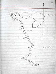
- ↑ Original from the proceedings of the Alexander Commission, p. 33. 2 March 1898. Image taken from Charlie Hale, "Regarding the Boundary Between Costa Rica and Nicaragua," Google LatLong Blog, 5 Nov. 2010.
- ↑ Esteban A. Mata (2010-11-03). "Nicaragua usa 'error' en mapa de Google para justificar incursión". La Nación (San José) (in Spanish). Retrieved 2010-11-16.
- 1 2 Asher Moses (2010-11-12). "Conflict reaches boiling point as Google errs again". The Sidney Morning Herald. Retrieved 2010-11-12.
- 1 2 Peter Walker (2010-11-11). "Nicaragua to keep troops in disputed territory after Google Maps error". The Guardian. Retrieved 2010-11-16.
- 1 2 3 Adam Williams and Tim Rogers (2010-11-05). "Google Maps Blamed for Conflict Between Costa Rica and Nicaragua". Tico Times. Retrieved 2010-11-16.
- ↑ "Costa Rican-Nicaraguan Country Border Updated on Google Earth". Google. 2010-11-12. Retrieved 2010-11-14.
- 1 2 "Tropas se mantendrán en territorio nicaragüense". La Prensa (Managua) (in Spanish). 2010-11-13. Archived from the original on 2010-11-15. Retrieved 2010-11-14.
- ↑ "OAS urges pullout of Costa Rican, Nicaraguan troops". Yahoo News. 2010-11-13. Retrieved 2010-11-12.
- ↑ Octavio Enríquez, Lucydalia Baca C (2010-11-14). "Nicaragua no acatará pedido OEA". La Prensa (Managua) (in Spanish). Retrieved 2010-11-16.
- 1 2 Alvaro Murillo (2010-11-12). "Arias critica manejo de conflicto y propone trasladarlo a la ONU". La Nación (San José) (in Spanish). Retrieved 2010-11-16.
- ↑ Alvaro Murillo (2010-11-18). "Costa Rica lleva conflicto a Corte de La Haya". La Nación (San José) (in Spanish). Retrieved 2010-11-21.
- ↑ "Costa Rica institutes proceedings against Nicaragua and requests the Court to indicate provisional measures" (PDF). International Court of Justice Press Release No. 2010/38. 2010-11-19. Retrieved 2010-11-21.
- ↑ Alvaro Murillo (2010-11-18). "País logra en OEA elevar reclamo a cancilleres". La Nación (San José) (in Spanish). Retrieved 2010-11-21.
- ↑ "OAS Permanent Council Approves Resolution Introduced by Costa Rica to Convene a Consultative Meeting of Ministers of Foreign Affairs". Organization of American States Press Release. 2010-11-18. Retrieved 2010-11-21.
- ↑ International Court of Justice recent provisional Costa Rica-Nicaragua decision
- ↑
- ↑ Case Concerning Certain Activities carried out by Nicaragua in the Border Area (Costa Rica v. Nicaragua), International Court of Justice, 16 December 2015