Cosmas Indicopleustes
Cosmas Indicopleustes (Greek Κοσμᾶς Ἰνδικοπλεύστης, literally "Cosmas who sailed to India"; also known as Cosmas the Monk) was an Greek merchant and later hermit from Alexandria of Egypt.[1] He was a 6th-century traveller, who made several voyages to India during the reign of emperor Justinian. His work Christian Topography contained some of the earliest and most famous world maps.[2][3][4] Cosmas was a pupil of the East Syrian Patriarch Aba I and was himself a follower of the Church of the East.[5][6]
Voyage
Around 550 Cosmas wrote the once-copiously illustrated Christian Topography, a work partly based on his personal experiences as a merchant on the Red Sea and Indian Ocean in the early 6th century. His description of India and Sri Lanka during the 6th century is invaluable to historians. Cosmas seems to have personally visited the Kingdom of Axum in modern Ethiopia, as well as Eritrea, India, and Sri Lanka.
Indicopleustes
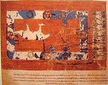
"Indicopleustes" means "Indian voyager". While it is known from classical literature, especially the Periplus Maris Erythraei that there had been trade between the Roman Empire and India from the 1st century BC onwards, Cosmas's report is one of the few from individuals who had actually made the journey. He described and sketched some of what he saw in his Topography. Some of these have been copied into the existing manuscripts, the oldest dating to the 9th century. In 522 AD, he visited the Malabar Coast (South India). He is the first traveller to mention Syrian Christians in India. He wrote, "In the Island of Taprobane (Ceylon), there is a church of the Christians, and clerks and faithful. Likewise at Malé where the pepper grows; and in the town of Kalliana, The present Day Kalyan where Comas used to rule, there is also a bishop consecrated in Persia." (Reference: Travancore Manual, page 248).
Christian Topography


A major feature of his Topographia is Cosmas' worldview that the world is flat, and that the heavens form the shape of a box with a curved lid. He was scornful of Ptolemy and others who held that the world was spherical. Cosmas aimed to prove that pre-Christian geographers had been wrong in asserting that the earth was spherical and that it was in fact modelled on the tabernacle, the house of worship described to Moses by God during the Jewish Exodus from Egypt. However, his idea that the earth is flat had been a minority view among educated Western opinion since the 3rd century BC.[7] Cosmas's view was never influential even in religious circles; a near-contemporary Christian, John Philoponus, disagreed with him as did many Christian philosophers of the era.[2]
David C. Lindberg asserts: "Cosmas was not particularly influential in Byzantium, but he is important for us because he has been commonly used to buttress the claim that all (or most) medieval people believed they lived on a flat earth. This claim...is totally false. Cosmas is, in fact, the only medieval European known to have defended a flat earth cosmology, whereas it is safe to assume that all educated Western Europeans (and almost one hundred percent of educated Byzantines), as well as sailors and travelers, believed in the earth's sphericity."[8]
Cosmology aside, Cosmas proves to be an interesting and reliable guide, providing a window into a world that has since disappeared. He happened to be in Adulis on the Red Sea Coast of modern Eritrea at the time (c. 525 AD) when the King of Axum was preparing a military expedition to attack the Jewish king Dhu Nuwas in Yemen, who had recently been persecuting Christians. On request of the Axumite king and in preparation for this campaign, he recorded now-vanished inscriptions such as the Monumentum Adulitanum (which he mistakenly attributed to Ptolemy III Euergetes).
See also
References
- ↑ Beatrice Nicolini, Penelope-Jane Watson, Makran, Oman, and Zanzibar: Three-terminal Cultural Corridor in the Western Indian Ocean (1799–1856), 2004, BRILL, ISBN 90-04-13780-7.
- 1 2 Encyclopædia Britannica, 2008, O.Ed, Cosmas Indicopleustes.
- ↑ Yule, Henry. Cathay and the Way Thither. Asian Educational Services. pp. 212–32. ISBN 978-81-206-1966-1.
- ↑ Miller, Hugh (1857). The Testimony of the Rocks. Boston: Gould and Lincoln. p. 428.
- ↑ Cosmas Indicopleustes (24 June 2010). The Christian Topography of Cosmas, an Egyptian Monk: Translated from the Greek, and Edited with Notes and Introduction. Cambridge University Press. p. 87. ISBN 978-1-108-01295-9. Retrieved 3 November 2012.
- ↑ Johnson, Scott (November 2012). The Oxford Handbook of Late Antiquity. Oxford University Press. p. 1019. ISBN 978-0-19-533693-1. Retrieved 3 November 2012.
- ↑ Russell, Jeffrey B. "The Myth of the Flat Earth". American Scientific Affiliation. Retrieved 2007-03-14.
- ↑ Lindberg, "The Beginnings of Western Science, 600 B.C. to A.D. 1450", p. 161
Further reading
- Kenneth Willis Clark collection of Greek Manuscripts: Cosmas Indicopleustes, Topographia.
- Cosmas Indicopleustes, ed. J.W. McCrindle (1897). The Christian Topography of Cosmas Indicopleustes. Hakluyt Society. (Reissued by Cambridge University Press, 2010. ISBN 978-1-108-01295-9)
- Cosmas Indicopleustes, Eric Otto Winstedt (1909). The Christian Topography of Cosmas Indicopleustes. The University Press
- Jeffrey Burton Russell (1997). Inventing the Flat Earth. Praeger Press
- Dr. Jerry H Bentley (2005). Traditions and Encounters. McGraw Hill.
- Wanda Wolska-Conus. La topographie chrétienne de Cosmas Indicopleustes: théologie et sciences au VIe siècle Vol. 3, Bibliothèque Byzantine. Paris: Presses Universitaires de France, 1962.
- Cosmas Indicopleustes. Cosmas Indicopleustès, Topographie chrétienne. Translated by Wanda Wolska-Conus. 2 vols. Paris: Les Editions du Cerf, 1968.
External links
 Chisholm, Hugh, ed. (1911). "Cosmas (of Alexandria)". Encyclopædia Britannica (11th ed.). Cambridge University Press.
- The Christian Topography by Cosmas Indicopleustes
- The Christian Topography by Cosmas Indicopleustes (other site)
- Greek Opera Omnia by Migne Patrologia Graeca with analytical indexes
- Scan of the entire Codex Vat.gr.699 on Biblioteca Apostolica Vaticana website
This article uses text taken from the Preface to the Online English translation of the Christian Topography, which is in the public domain.