Cortes Island
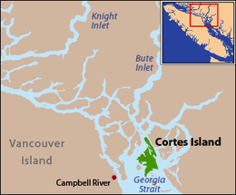 Cortes Island is located at the northern end of the Strait of Georgia. | |
| Geography | |
|---|---|
| Location | Strait of Georgia |
| Coordinates | 50°07′N 124°58′W / 50.117°N 124.967°W |
| Archipelago | Discovery Islands |
| Area | 130 km2 (50 sq mi) |
| Length | 25 km (15.5 mi) |
| Width | 13 km (8.1 mi) |
| Administration | |
| Demographics | |
| Population | 1042 (2006[1]) |
| Ethnic groups | Wei We Kai, Kwiakah, Homalco and Klahoose First Nations |
Cortes Island is part of the traditional territories of the We Wai Kai, Kwiakah, Homalco, and Klahoose First Nations, with the office of the Klahoose First Nation located on the island. The island's southern tip is also part of the traditional territory of the Sliammon people.
Cortes, which is in the Sayward Land District,[2] is 25 km (15.5 mi) long, 13 km (8.1 mi) wide, and 130 km2 (50 sq mi) in area. It has a population of 1,042 permanent residents (2006 census).[1] Cortes Island lies within Electoral Area B of the Strathcona Regional District,[3] which provides water and sewerage systems, fire protection, land use planning, parks, recreation, and emergency response.[4]
Cortes Island is in the Sunshine Coast Forest District and the Vancouver Island Ministry of Environment's Vancouver Island Region. It is part of the North Island Provincial Electoral District.[5] The Campbell River School District operates the Cortes Elementary / Jr. Secondary school on the island. Until recently there was also the Linnaea School, a non-traditional school which offered a different approach on education. It was closed due to a lack of students and funding. After the ninth grade, students must either switch to homeschooling or transfer to a school off the island.
The island was named in 1792 during the expedition of Galiano and Valdés, presumably after Hernán Cortés, the Spanish conqueror of Mexico.[6]:46[7]
Access to Cortes Island is by plane or ferry. By plane through a non-profit private airstrip Cortes Island Aerodrome on the south end of the island, or by seaplane to many of the island's protected harbours; by ferry from Quadra Island, which is itself accessed from Campbell River on Vancouver Island via BC Ferries.
Whaletown, Squirrel Cove and Mansons Landing are communities on the island. Desolation Sound is off the east shore of the island. Forestry, fishing and mining have featured in its history. There is also a campground at Smelt Bay Provincial Park.
Geography
Cortes Island is part of the archipelago known as the Discovery Islands in British Columbia, Canada, which lie beyond the northern end of the Gulf of Georgia, between Vancouver Island and the British Columbia Mainland. It is also considered to be part of the Northern Gulf Islands. Cortes lies on the far side of Quadra Island from the city of Campbell River, separated from Quadra Island by Sutil Channel. To the northeast of Cortes Island, across Lewis Channel, is West Redonda Island. Desolation Sound lies to the east of Cortes Island and, beyond that, the upper end of the Malaspina Peninsula. The island is located roughly halfway between Powell River and Campbell River.
Climate
| Climate data for Cortes Island (1971-2000) | |||||||||||||
|---|---|---|---|---|---|---|---|---|---|---|---|---|---|
| Month | Jan | Feb | Mar | Apr | May | Jun | Jul | Aug | Sep | Oct | Nov | Dec | Year |
| Record high °C (°F) | 15.0 (59) |
15.5 (59.9) |
19.4 (66.9) |
25.0 (77) |
31.5 (88.7) |
31.1 (88) |
31.7 (89.1) |
32.5 (90.5) |
28.5 (83.3) |
21.1 (70) |
16.0 (60.8) |
15.6 (60.1) |
32.5 (90.5) |
| Average high °C (°F) | 5.4 (41.7) |
7.0 (44.6) |
9.4 (48.9) |
12.6 (54.7) |
16.6 (61.9) |
19.2 (66.6) |
22.1 (71.8) |
21.9 (71.4) |
18.3 (64.9) |
12.7 (54.9) |
8.0 (46.4) |
5.5 (41.9) |
13.2 (55.8) |
| Daily mean °C (°F) | 3.4 (38.1) |
4.6 (40.3) |
6.5 (43.7) |
9.1 (48.4) |
12.7 (54.9) |
15.4 (59.7) |
17.9 (64.2) |
17.9 (64.2) |
14.8 (58.6) |
10.1 (50.2) |
5.9 (42.6) |
3.7 (38.7) |
10.2 (50.4) |
| Average low °C (°F) | 1.4 (34.5) |
2.2 (36) |
3.5 (38.3) |
5.6 (42.1) |
8.8 (47.8) |
11.5 (52.7) |
13.6 (56.5) |
13.8 (56.8) |
11.1 (52) |
7.4 (45.3) |
3.8 (38.8) |
1.8 (35.2) |
7.1 (44.8) |
| Record low °C (°F) | −10.6 (12.9) |
−11 (12) |
−6.1 (21) |
−1.1 (30) |
1.7 (35.1) |
2.8 (37) |
5.0 (41) |
7.8 (46) |
2.2 (36) |
−3.5 (25.7) |
−11 (12) |
−13.9 (7) |
−13.9 (7) |
| Average precipitation mm (inches) | 172.7 (6.799) |
133.2 (5.244) |
116.1 (4.571) |
90.6 (3.567) |
70.2 (2.764) |
65.1 (2.563) |
50.5 (1.988) |
58.8 (2.315) |
71.7 (2.823) |
150.1 (5.909) |
211.9 (8.343) |
187.7 (7.39) |
1,378.6 (54.276) |
| Average rainfall mm (inches) | 147.9 (5.823) |
121.0 (4.764) |
110.6 (4.354) |
88.6 (3.488) |
70.2 (2.764) |
65.1 (2.563) |
50.5 (1.988) |
58.8 (2.315) |
71.7 (2.823) |
149.6 (5.89) |
207.0 (8.15) |
167.8 (6.606) |
1,308.7 (51.524) |
| Average snowfall cm (inches) | 24.8 (9.76) |
12.2 (4.8) |
5.5 (2.17) |
2.0 (0.79) |
0.0 (0) |
0.0 (0) |
0.0 (0) |
0.0 (0) |
0.0 (0) |
0.6 (0.24) |
4.9 (1.93) |
19.9 (7.83) |
69.9 (27.52) |
| Average precipitation days (≥ 0.2 mm) | 19.2 | 17.3 | 17.9 | 16.0 | 13.7 | 12.6 | 8.6 | 9.2 | 10.2 | 16.6 | 21.3 | 20.7 | 183.4 |
| Average rainy days (≥ 0.2 mm) | 17.3 | 15.9 | 17.5 | 16.0 | 13.7 | 12.6 | 8.6 | 9.2 | 10.2 | 16.6 | 21.1 | 18.5 | 177.2 |
| Average snowy days (≥ 0.2 cm) | 3.8 | 2.5 | 1.7 | 0.46 | 0.0 | 0.0 | 0.0 | 0.0 | 0.0 | 0.08 | 1.2 | 3.6 | 13.4 |
| Source: Environment Canada[8] | |||||||||||||
References
- 1 2 Statistics Canada population figures
- ↑ "Land Districts, geographic metadata". GeoBC. Retrieved 17 September 2013. Accessed with "iMap 2.0". British Columbia, Geographic Services. Retrieved 17 September 2013.
- ↑ "Description of Strathcona Regional District Areas' Boundaries". Strathcona Regional District. Retrieved 17 September 2013.
- ↑ "About Us". Strathcona Regional District. Retrieved 17 September 2013.
- ↑ "Provincial Electoral Districts, geographic metadata". GeoBC. Retrieved 17 September 2013. Accessed with "iMap 2.0". British Columbia, Geographic Services. Retrieved 17 September 2013.
- ↑ Akrigg, G.P.V.; Akrigg, Helen B. (1969), 1001 British Columbia Place Names (3rd, 1973 ed.), Vancouver: Discovery Press
- ↑ BC Names entry "Cortes Island"
- ↑ "Cortes Island". Canadian Climate Normals 1971–2000. Environment Canada. Retrieved 2016-11-04.
External links
- cortesisland.com Cortes Island news and information website.
- Cortes Island Coastal Plan for Shellfish Aquaculture