Coronie District
| Coronie | |
|---|---|
| District | |
.jpg) | |
 Map of Suriname showing Coronie district | |
| Coordinates: 5°46′N 56°17′W / 5.767°N 56.283°W | |
| Country | Suriname |
| Capital | Totness |
| Area | |
| • Total | 3,902 km2 (1,507 sq mi) |
| Population (2012 census) | |
| • Total | 3,391 |
| • Density | 0.87/km2 (2.3/sq mi) |
| Time zone | ART (UTC-3) |
Coronie is a district of Suriname, situated on the coast. Coronie's capital city is Totness, with other towns including Corneliskondre, Friendship, Jenny. The district border the Atlantic Ocean to the north, the Surinamese district of Saramacca to the east, the Surinamese district of Sipaliwini to the south and the Surinamese district of Nickerie to the west. The Totness Airstrip is one of the oldest airport in Suriname, in use since 1953, when the Piper Cub (PZ-NAC) of Kappel-van Eyck named "Colibri" landed there from Zorg en Hoop Airport.
The district has a population of 3,480 and an area of 3,902 km².
Coronie, as with most of Suriname, relies mostly upon agriculture for both its income and its food supply. The coastal environment means that many coconut and rice plantations exist.
In September 1965 4 sounding rockets of Apache type with a maximum altitude of 205 km were launched. [1]
Resorts
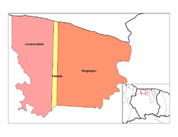
Coronie is divided into 3 resorts (ressorten):
References
| Brokopondo District |  | |
|---|---|---|
| Commewijne District | ||
| Coronie District | ||
| Marowijne District | ||
| Nickerie District | ||
| Para District | ||
| Paramaribo District | ||
| Saramacca District | ||
| Sipaliwini District | ||
| Wanica District | ||
Coordinates: 5°45′49″N 56°16′40″W / 5.76361°N 56.27778°W