Cornubian batholith
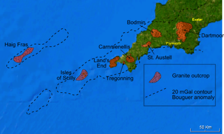
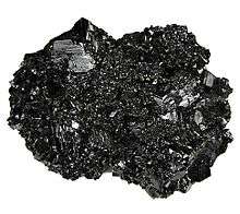
The Cornubian batholith is the group of associated granite intrusions which underlie the south-western peninsula of Great Britain. The main exposed masses of the batholith are seen at Dartmoor, Bodmin Moor, St Austell, Carnmenellis, Land's End and the Isles of Scilly. It formed during the early Permian period, from about 300 to 275 Ma (million years ago), at a late stage in the Variscan orogeny. The granites are classified as S-type, interpreted to be derived from the partial melting of a sedimentary protolith. The intrusions are associated with significant mineralization, particularly tin, for which the area has been famous since about 2000 BC.[1] It takes its name from Cornubia, the Medieval Latin name for Cornwall.
Extent and geometry
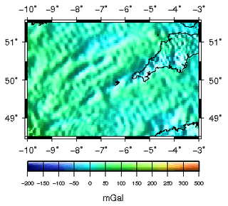
From gravity and magnetic geophysical data, the batholith is interpreted to extend from about 8°W, more than 100 km southwest of the Isles of Scilly, to the eastern edge of Dartmoor. The negative gravity anomaly, caused by the relatively low density of the granites compared to average continental crust, is linear and trends WSW-ENE, parallel with that associated with the Haig Fras granite.[2]
The shape of the batholith and the relationship between the individual plutons and the main mass of the granite remained entirely speculative until gravity data began to be used to constrain the thickness and shape of the batholith by modelling. The initial work by Martin Bott suggested that the batholith had an overall trapezoidal shape with a base to the batholith at about 10–12 km. However, current understanding of granite pluton shape suggest that most are either laccolithic or lopolithic. Comparisons with other examples would suggest that the thicknesses of the individual plutons would be in the range 3–5 km, based on their outcrop widths.[3]
Mineralogy and chemistry
Mineralogy
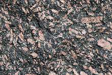
The Cornubian intrusions are two-mica granites, containing both muscovite and biotite. Li-mica granite forms a less common type found only in the St. Austell pluton and some smaller intrusions. Many of the granites contain large alkali feldspar megacrysts.[4] Locally the tourmaline-bearing granite luxullianite is developed by the tourmalinization of the original granite.
Chemistry
The two-mica granites are strongly peraluminous, with a low ratio of sodium to potassium and overall high level of alkalis. The granites are highly enriched in lithium, boron, caesium and uranium and moderately so in fluorine, gallium, germanium, rubidium, tin, tantalum, tungsten and thallium. Given the overall chemistry, the levels of phosphorus are also high. Strontium, barium and the elements from scandium to zinc are relatively depleted. This chemistry is consistent with partial melting of a source consisting of greywackes. The conditions under which the melts formed is modelled to be temperature of 770 °C and a confining pressure of 50 MPa.[5]
Differences in chemistry have been identified between an earlier group of plutons (Isles of Scilly, Carnmenellis & Bodmin Moor) and a later group (Land's End, St Austell & Dartmoor). The early group of granites are more aluminous than the later set and have steeper slopes on plots of cerium against yttrium. The later group contain more common basic microgranite enclaves.[6]
Ammonium content
The granites are generally rich in ammonium compared to average granites world-wide. There is also considerable variation between the individual plutons, with an average of 11 ppm for Dartmoor compared to 94 ppm for Bodmin Moor. The concentration of ammonium in these granites correlates well with both their initial 87
Sr/86
Sr ratios and their peraluminosity. The relatively high ammonium content is interpreted to indicate that the granites were derived from a sedimentary protolith, or have been contaminated from such a source after emplacement to high crustal levels.[7]
Tectonic setting and origin
The granitic intrusions that form the batholith were intruded towards the end of the Variscan orogeny, as a suite of late orogenic granites. It has been suggested that crustal extension allowed the granitic magmas to move to higher crustal levels. Evidence from neodymium and strontium isotopes suggests that the magmas that formed the batholith were mainly the result of partial melting of the lower crust with a minor component of basaltic magma from a mantle source. This lower crustal source is likely to have consisted of both metasedimentary and metavolcanic rocks, of Proterozoic age.[8]
Emplacement
Mechanism
As with all large intrusive bodies, the mechanism of emplacement of the Cornubian batholith is a matter of debate, due to the space problem of adding such large masses to the upper crust.[9] Four main mechanisms have been proposed; stoping, diapirism, extensional faulting and uplift of the overlying country rock over a laccolithic sill with a relatively small vertical dyke feeder.
Evidence for a stoping mechanism has been described locally from the margin of the Tregonning intrusion, where a series of intrusive sheets extend out from the roof zone of the intrusion into the country-rock.[10] Although the Land's End pluton was once thought to have a diapiric origin, its emplacement is now interpreted to have been accommodated by fault movements during regional extension.[11]
Timing
An approximate age of emplacement for the Cornubian batholith was known before radiometric dating methods became commonplace, from the observed relationships with sedimentary sequences. The youngest rocks intruded by the granites, the Carboniferous Crackington and Bealsmill formations of Namurian to lower Westphalian in age,[12][13] provide a lower bound for the timing of granite emplacement of about 310 Ma. The earliest instance of granitic clasts in younger sedimentary sequences, the Late Permian St. Cyres beds,[14] gives an upper bound of about 250 Ma. The inferred age of emplacement from this evidence of Late Carboniferous to Early Permian has been confirmed by radiometric dating, although it has shown that the individual intrusions were emplaced over a significant time interval. The earliest dated major intrusion is the Carnmenellis pluton at 293.1±3 Ma. The youngest dated granite is the southern lobe of the Land's End pluton, intruded at 274.5±1.4 Ma.[15] The earliest recorded magmatic activity is the intrusion of the small Hemerdon pluton on the southwestern flank of the Dartmoor pluton at 298.3±2.3 Ma. There is no apparent systematic variation in age of plutons compared to their position within the batholith. This suggest that the batholith has grown by the coalescence of a series of separate intrusions over a period of about 25 Ma.[16]
Plutons
Several major plutons are recognised, which are all compositionally distinct apart from the Bodmin Moor and Carnmenellis intrusions, which cannot be discriminated on this basis.[5]
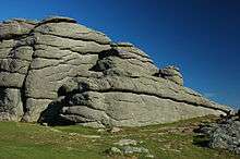
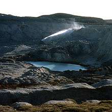
Dartmoor
The largest exposed area of granite, it also forms the easternmost development of the batholith. The granite consists of two main types, coarse-grained granite with abundant large alkali feldspar megacrysts and coarse-grained granite with few megacrysts. To the southwest there is an area of coarse-grained granite with small megacrysts and several small exposures of fine-grained granite, particularly in the southeastern part of the outcrop.[4] Interpretation of the gravity field over this pluton suggests that it is sheet-like with a thickness of nearly 10 km, and a root at its southern end extending down to about 17 km depth, which may represent the conduit that carried the magma to shallow crustal levels. It appears to have been intruded along the interface between Devonian and Carboniferous rocks.[3] Uranium-lead dating of Monazite from this intrusion gives emplacement ages of 278.2±0.8 Ma and 280.4±1.2 Ma.[16]
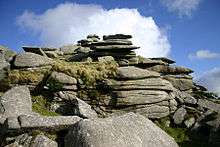
Bodmin Moor
The Bodmin Moor pluton consist mainly of coarse-grained granite with abundant small megacrysts. Towards the centre and the western margin of the outcrop there are smaller bodies of fine-grained granite.[4] Gravity data suggest that this pluton is in the form of a south-southeastward thickening wedge, reaching a maximum of about 7 km.[3] Monazite from this pluton gives an emplacement age of 291.4±0.8 Ma.[16]
St Austell
The St Austell pluton consists of coarse-grained megacrystic granite with large megacrysts at the western and eastern ends of the outcrop. The central part of the pluton is also coarse-grained but lacks the megacrysts. Between the central megacryst poor and the large megacryst rich coarse-grained granites at the western end, a medium-grained granite is developed with lithium-mica. Smaller bodies of fine-grained granite are found in the central part of the outcrop and at the western end.[4] Gravity data indicate that this pluton is wedge-shaped similar to that at Bodmin.[3] Monazite gives an emplacement age of 281.8±0.4 Ma for this pluton.[16]
Carnmenellis
The Carnmenellis pluton and the smaller intrusions of Tregonning-Godolphin, Carn Brea and Carn Marth appear to be part of a single intrusive body. The central part of the Carnmenellis outcrop is a medium-grained granite with few megacrysts. The bulk of the main outcrop and the Carn Brea and Carn Marth masses consist of coarse-grained megacrystic granite with small megacrysts. Small bodies of fine-grained granite are found towards the west of the Carnemellis outcrop. The Tregonning-Godolphin outcrop is mainly a medium-grained lithium-mica granite with a body of fine-grained granite developed towards the northwest of the outcrop.[4] The shape of this pluton is interpreted to be a sheet about 3 km thick with a near central root extending down to about 7 km depth.[3] Monazite gives an emplacement age of 293.7±0.6 Ma for this pluton.[16]
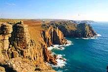
Land's End
The Land's End pluton is mainly a coarse-grained granite with abundant large megacrysts. There is an area in the centre which is poor in megacrysts and there are several small and medium-sized masses of fine-grained granite throughout the outcrop.[4] Dating has been carried out on xenotime and monazite samples, from a fine-grained granite and the main coarse-grained granite respectively. These give emplacement ages of 279.3±0.4 Ma for the fine-grained granite and 274.8±0.5 Ma for the main phase granite. This difference is consistent with fine-grained granite being a roof-pendant to the coarse-grained main phase granite intrusion.[16]
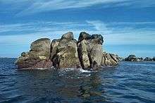
Isles of Scilly
The Isles of Scilly all have granite bedrock. The dominant rock type is a megacrystic biotite granite, although the megacrysts are relatively small. In the centre of the pluton a medium-grained granite is developed with few megacrysts, more tourmaline and less biotite than the main variety.[4][17] Monazite from this pluton suggest an emplacement age of 290.3±0.6 Ma.[15]
Haig Fras
This submarine outcrop, 45 km in length, lies 95 km northwest of the Scilly Isles, rising to a minimum of 38 m below the sea surface.[18] In contrast to most granites of the Cornubian batholith the granites here are fine to medium-grained and generally lack megacrysts. It was intruded at 277 Ma and is considered most likely to be a separate but related intrusive body that runs parallel to the Cornubian batholith.[19][20]
Other intrusions
Minor granitic intrusions are present throughout the peninsula. Many of these are connected to one of the larger plutons, such as the Tregonning granite, which appears to be part of the Carnmenellis pluton from its similar composition and indications from gravity data.[21] In some cases granitic bodies have been recognised from the mineralisation above them, even if the intrusion itself has not been encountered.
A series of minor intrusions are found within the country rock and the granites themselves. Common types are pegmatites, aplites and elvans.[22][23]
Associated metamorphism and metasomatism
Contact metamorphic effects are found around many of the plutons.
A feature of the granites of the batholith is the high concentrations of volatile components. Fluids rich in these have strongly affected the country rock and locally the granites themselves. The first phase recognised is potassium–metasomatism followed by sodium–metasomatism and finally acid metasomatism.[24]
Associated mineralisation
Skarns
The first phase of mineralization is the formation of exoskarns caused by the metasomatism of shales and metabasalts. Typical minerals formed at this time include garnet, pyroxene, epidote, Cl-rich amphiboles, malayaite, vesuvianite, siderite and axinite. The skarns may contain economic amounts of tin, copper, iron and arsenic. Minerals formed at this stage give ages close to the crystallization age for the particular pluton.[16]
Tin and tungsten
The second phase of mineralization recognised is associated with greisenization and tourmalinization of the granite by high-temperature late magmatic fluids rich in volatiles. Veins of cassiterite and wolframite are found associated with the greisens, the former deposited by high salinity, low CO
2, fluids and the latter by low salinity high CO
2 fluids. Muscovites within the greisens give cooling ages similar to magmatic muscovites in the relevant granite.[16]
The third and main phase of mineralization occurs at a later stage, at lower temperatures and involves deposition in veins by fluids circulating within the country rock, leaching out tin, copper and arsenic. The typical fill of these veins is quartz-tourmaline-chlorite-sulfide-fluorite, with tin, copper, lead, zinc, iron and arsenic sulfides. The dominant trend for mineral veins of this stage is W-E. This mineralization is 25–40 Ma later than the intrusion age for the Carnmenellis pluton.[16]
Lead and zinc
Lead and zinc mineralization is associated with north-south to northwest-southeast trending veins, known as the 'crosscourses' as they cross-cut the earlier W-E trending veins. Studies on quartz fluid inclusions suggest that this mineralization was caused by fluid derived from Permo-Triassic sedimentary sequence that once covered the entire area and is still preserved in the Southwest Approaches to the English Channel. Evidence of seawater influence suggest that the mineralization did not start until the Late Triassic marine incursion at the earliest. The high heatflow from the granites helped drive fluid circulation.[25]
China clay

Alteration of feldspars by kaolinization is common throughout the batholith and has locally formed large economic deposits of china clay, such as Lee Moor on the western edge of Dartmoor and the St Austell district. The kaolinization is thought to have resulted from intense supergene weathering in a tropical to warm climate during the Cretaceous to Cenozoic, based on studies of D/H and 18
O/16
O ratios.[26]
References
- ↑ Emsley, J. (2003). Nature's building blocks: an A-Z guide to the elements. Popular Science. Oxford University Press. p. 447. ISBN 978-0-19-850340-8. Retrieved 12 January 2011.
- ↑ Edwards, J.W.F. (1984). "Interpretations of seismic and gravity surveys over the eastern part of the Cornubian platform". In Hutton D.H.W. & Sanderson D.J. Variscan Tectonics of the North Atlantic Region. Special Publications. 14. London: Geological Society. pp. 119–124. Retrieved 5 December 2010.
- 1 2 3 4 5 Taylor, G.K. (2007). "Pluton shapes in the Cornubian Batholith: new perspectives from gravity modelling". Journal of the Geological Society. 164 (3): 525–528. doi:10.1144/0016-76492006-104. Retrieved 13 January 2011.
- 1 2 3 4 5 6 7 Dangerfield, J.; Hawkes J.R. (1981). "The Variscan Granites of south-west England: additional information" (PDF). Proceedings of the Ussher Society. 5: 116–120. Retrieved 12 January 2011.
- 1 2 Chappell, B.W.; Hine R. (2006). "The Cornubian Batholith: an Example of Magmatic Fractionation on a Crustal Scale". Resource Geology. 56 (3): 203–244. doi:10.1111/j.1751-3928.2006.tb00281.x.
- ↑ Stone, M. (2000). "The early Cornubian plutons: a geochemical study, comparisons and some implications" (PDF). Geoscience in south-west England. 10: 37–41. Retrieved 15 January 2011.
- ↑ Hall, A. (1988). "The distribution of ammonium in granites from South-West England". Journal of the Geological Society. 145 (1). doi:10.1144/gsjgs.145.1.0037. Retrieved 12 January 2011.
- ↑ Darbyshire, D.P.F.; Shepherd T.J. (1994). "Nd and Sr isotope constraints on the origin of the Cornubian batholith, SW England". Journal of the Geological Society. 151 (5). doi:10.1144/gsjgs.151.5.0795. Retrieved 15 January 2011.
- ↑ Park, R.G. (2004). Foundation of Structural Geology (3 ed.). Routledge. pp. 128–129. ISBN 978-0-7487-5802-9.
- ↑ Leboutillier, Nick (22 January 2003). "Megiliggar Rocks". Cornish Geology Website. Retrieved 15 January 2011.
- ↑ Powell, T.; Salmon S.; Clark A.H.; Shail R.K. (1999). "Emplacement styles within the Land's End Granite, west Cornwall" (PDF). Geoscience in south-west England. 9: 333–339. Retrieved 15 January 2011.
- ↑ Page, K.N. (2006). "Information Sheet 1D: Blackdown Nappe: Late Lower to Upper Carboniferous, Bealsmill Formation ('allochthon')" (PDF). Meldon Geology & Geomorphology Case Study. Dartmoor National Park Authority. Retrieved 17 January 2011.
- ↑ Page, K.N. (2006). "Information Sheet 1B: Late Lower to Upper Carboniferous: Crackington Formation (Culm Basin 'autochthon' / 'parautochthon')" (PDF). Meldon Geology & Geomorphology Case Study. Dartmoor National Park Authority. Retrieved 17 January 2011.
- ↑ Dangerfield, J.; Hawkes J.R. (1969). "Unroofing of the Dartmoor granite and possible consequences with regard to mineralization" (PDF). Proceedings of the Ussher Society. 2 (2): 122–131. Retrieved 17 January 2011.
- 1 2 Chen, Y.; Clark A.H.; Farrar E.; Wasteneys H.A.H.P.; Hodgson M.J.; Bromley A.V. (1993). "Diachronous and independent histories of plutonism and mineralization in the Cornubian Batholith, southwest England". Journal of the Geological Society. 150 (6): 1183–1191. doi:10.1144/gsjgs.150.6.1183. Retrieved 13 January 2011.
- 1 2 3 4 5 6 7 8 9 Chesley, J.T.; Halliday A.N.; Snee L.W.; Mezger K.; Shepherd T.J.; Scrivener R.C. (1993). "Thermochronology of the Cornubian batholith in southwest England: Implications for pluton emplacement and protracted hydrothermal mineralization" (PDF). Geochimica et Cosmochimica Acta. 57 (8): 1817–1835. Bibcode:1993GeCoA..57.1817C. doi:10.1016/0016-7037(93)90115-D. Retrieved 13 January 2011.
- ↑ Stone, M.; Exley C.S. (1989). "Geochemistry of the Isles of Scilly pluton" (PDF). Proceedings of the Ussher Society. 7: 152–157. Retrieved 12 January 2011.
- ↑ Joint Nature Conservation Committee (2008). "Offshore Special Area of Conservation: Haig Fras SAC Selection Assessment" (PDF). p. 14. Retrieved 10 January 2011.
- ↑ Edwards, J.W.F.; Briant, M.; Arthur, M.J. (1991). "Proposed Mesozoic dykes in the Celtic Sea" (PDF). Proceedings of the Ussher Society. 7: 344–349. Retrieved 10 January 2011.
- ↑ Jones, D.G.; Miller J.M.; Roberts P.D. (1988). "A seabed radiometric survey of Haig Fras, S. Celtic Sea, U.K.". Proceedings of the Geologists' Association. 99 (3): 193–203. doi:10.1016/S0016-7878(88)80035-X. Retrieved 10 January 2011.
- ↑ Beer, K.E.; Burley, A.J.; Tombs, J.M. (1975). The concealed granite roof in south-west Cornwall (PDF). Mineral Reconnaissance Programme Report. 1. Institute of Geological Sciences. p. 15. Retrieved 17 January 2011.
- ↑ "The Geology of Cornwall". University College London, Department of Earth Sciences. Retrieved 17 January 2011.
- ↑ Mullis, S.J.L.; Salmon S.; Powell T. (2001). "Insights into the formation of the Isles of Scilly pluton" (PDF). Geoscience in south-west England. 10. Retrieved 17 January 2011.
- ↑ Pirajno, F. (2009). "Intrusion-related hydrothermal mineral systems". Hydrothermal processes and mineral systems. Springer. p. 241. Retrieved 13 January 2011.
- ↑ Gleeson, S.A.; Wilkinson J.J.; Stuart F.M.; Banks D.A. (2001). "The origin and evolution of base metal mineralising brines and hydrothermal fluids, South Cornwall, UK" (PDF). Geochimica et Cosmochimica Acta. 65 (13): 2067–2079. Bibcode:2001GeCoA..65.2067G. doi:10.1016/S0016-7037(01)00579-8. Retrieved 13 January 2011.
- ↑ Sheppard, S. M. F. (1977). "The Cornubian Batholith, SW England: D/H and 18
O/16
O studies of kaolinite and other alteration minerals". Journal of the Geological Society. 133 (6): 573–591. doi:10.1144/gsjgs.133.6.0573. Retrieved 13 January 2011.
External links
Coordinates: 50°12′N 5°12′W / 50.2°N 5.2°W