Cornmill Stream and Old River Lea
| Site of Special Scientific Interest | |
 | |
| Area of Search | Essex |
|---|---|
| Grid reference | TL380013 |
| Interest | Biological |
| Area | 24.6 hectares |
| Notification | 1986 |
| Location map | Magic Map |
The Cornmill Stream and Old River Lea is a 24.6 hectare biological Site of Special Scientific Interest in Waltham Abbey, Essex.[1][2]
Location
The site is bounded by a channel of the Old River Lea to the north and west which formed a boundary with the former Royal Gunpowder Mills. To the east flows the Cornmill Stream and the southern boundary is formed by the B194 road (Abbey View).
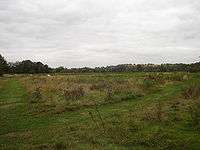
Habitat
The slow-moving Cornmill Stream and Old River Lea form a freshwater habitat with one of the most diverse invertebrate fauna in Essex. Eighteen species of dragonflies and damselflies have been recorded and includes the uncommon and nationally declining white-legged damselfly. The watercourses support a rich and varied aquatic and marginal flora and the site also includes rough grassland which provides feeding and breeding grounds for invertebrates and birds.[1]
References
- 1 2 "Cornmill Stream and Old River Lea citation" (PDF). Sites of Special Scientific Interest. Natural England. Retrieved 8 December 2015.
- ↑ "Map of Cornmill Stream and Old River Lea". Sites of Special Scientific Interest. Natural England. Retrieved 8 December 2015.
| Wikimedia Commons has media related to Cornmill Stream and Old River Lea. |
Coordinates: 51°41′36″N 0°00′19″W / 51.6934°N 0.0053°W