Cordillera Occidental (Colombia)
| Cordillera Occidental (West Andes) | |
|---|---|
 | |
| Highest point | |
| Peak | Cerro Tatamá [1] |
| Elevation | 4,100 m (13,500 ft) |
| Dimensions | |
| Length | 1,200 km (750 mi) north-south |
| Area | 86,239 km2 (33,297 sq mi) |
| Geography | |
| Country | Colombia |
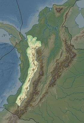
The Cordillera Occidental (English: West Andes) is the lowest in elevation of the three branches of the Colombian Andes. The average altitude is 2,000 m (6,600 ft) and the highest peak is Cerro Tatamá at 4,100 m (13,500 ft). The range extends from south to north dividing from the Colombian Massif in Nariño Department, passes north through Cauca, Valle del Cauca, Risaralda, Chocó, and Caldas Departments to the Paramillo Massif in Antioquia and Córdoba Departments. From this massif the range divides further to form the Serranías de Ayapel, San Jerónimo and Abibe. Only to recede into the Caribbean plain and the Sinú River valley.
Geography
The western part of the mountain range belongs to the Pacific region, with the San Juan River being the main watershed, while the eastern part belongs to the Cauca River basin. The northern and northwestern parts belong to the Atlantic Slope, with the Atrato and Sinú Rivers being the main watersheds. The Cordillera Occidental is separated from the coastal Baudó Mountains by the Atrato River.
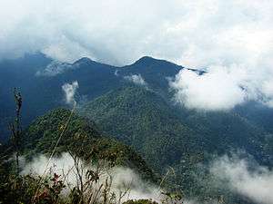
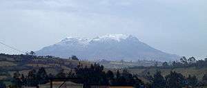
Highest Peaks
- Cerro Tatamá - 4,100 m (13,500 ft) - Chocó & Risaralda
- Farallones de Cali - 4,050 m (13,290 ft) - Valle del Cauca
- Farallones de Citará - 4,050 m (13,290 ft) - Antioquia
- Páramo de Frontino - 3,950 m (12,960 ft) - Antioquia
- Cerro Caramanta - 3,900 m (12,800 ft) - Antioquia, Caldas & Risaralda
- Cerro Napi - 3,860 m (12,660 ft) - Cauca
- Alto Musinga - 3,850 m (12,630 ft) - Antioquia
- Cerro Calima - 3,840 m (12,600 ft) - Valle del Cauca
- Cerro Paramillo - 3,730 m (12,240 ft) - Antioquia
- Cerro Ventana - 3,450 m (11,320 ft) - Valle del Cauca & Chocó
Protected Areas
The West Andes have the following nationally protected areas from south to north:
- PNN Munchique
- PNN Farallones de Cali
- PNN Tatamá
- PNN Las Orquídeas
- PNN Paramillo
Other areas under consideration for national protection include:
- Serranía del Pinche
- Serranía de los Paraguas
Locally Protected Areas
- Yotoco Forest Reserve
- Bitaco River Forest Reserve
Recreation Areas
References
- ↑ "Cordillera Occidental (Colombia)". Retrieved 8 August 2012.
See also
- Geography of Colombia
- Andean Region, Colombia
- Cordillera Central (Colombia)
- Cordillera Oriental (Colombia)
Mountain Ranges of Colombia | ||||||||||||||||
|---|---|---|---|---|---|---|---|---|---|---|---|---|---|---|---|---|
| Colombian Andes |
| .svg.png) | ||||||||||||||
| Isolated Ranges | ||||||||||||||||