Cordillera Apolobamba
| Apolobamba | |
|---|---|
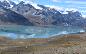 Such'i Lake in the Apolobamba Integrated Management Natural Area | |
| Highest point | |
| Peak | Chawpi Urqu |
| Elevation | 6,044 m (19,829 ft) |
| Coordinates | 14°39′S 69°14′W / 14.650°S 69.233°WCoordinates: 14°39′S 69°14′W / 14.650°S 69.233°W |
| Geography | |
 Satellite image of Apolobamba | |
| Countries | Peru and Bolivia |
| Parent range | Andes |
Apolobamba (Cordillera (de) Apolobamba) is a mountain range in the South American Andes.
Geographical Location
It is located in the eastern borderland of Peru and Bolivia. On the Bolivian side it is situated in the La Paz Department and on the Peruvian side it lies in the Puno Region. It stretches across a distance of 50 km from east to west and 30 km from north to south.
Curva, the main locality of the Kallawaya-people, is located 3,800 m above sea level.
Mountains
The highest mountain in the range is Chawpi Urqu, also known as Wisk'achani, at 6,044 metres (19,829 ft). Other notable peaks are:[1][2][3][4][5]
|
|
Lakes
The largest lake in the range is Such'i Lake. Such'i is what the Aymara and Quechua people call a little fish which lives in the cold waters of the lakes and rivers of the Altiplano.[6] Other lakes are listed below:
- Ch'uxña Quta (Curva)
- Ch'uxñaquta (Putina)
- Cololo Lake
- K'ayrani Quta
- K'iski Quta
- Qachu Quta
- Qaqa Waychu
- Qillwa Quta
- Q'illu Qucha
See also
References
- ↑ BIGM map 1:100,000 3041 Pelechuco
- ↑ escale.minedu.gob.pe/ UGEL map Sandia Province and Putina Province (Puno Region)
- ↑ Jill Neate, Mountaineering in the Andes, Bolivia, RGS-IBG Expedition Advisory Centre, 2nd edition, May 1994
- ↑ John Biggar, The Andes - A Guide for Climbers
- ↑ "Curva". ine.gob.bo. Archived from the original on October 29, 2014. Retrieved December 12, 2014.
- ↑ Teofilo Laime Ajacopa, Diccionario Bilingüe Iskay simipi yuyayk'ancha, La Paz, 2007 (Quechua-Spanish dictionary)
External links
| Wikimedia Commons has media related to Cordillera de Apolobamba. |
- "Trekking in the Cordillera Apolobamba"
- "Mountaineering information for the Cordillera Apolobamba (British Expedition)"
- "Mountaineering information for the Cordillera Apolobamba (Swedish Expedition)"