Corby (UK Parliament constituency)
| Corby | |
|---|---|
|
County constituency for the House of Commons | |
|
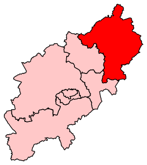
Boundary of Corby in Northamptonshire. | |
|
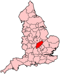
Location of Northamptonshire within England. | |
| County | Northamptonshire |
| Electorate | 79,468 (December 2010)[1] |
| Major settlements | Corby, Oundle, Raunds, Thrapston and Irthlingborough |
| Current constituency | |
| Created | 1983 |
| Member of parliament | Tom Pursglove (Conservative) |
| Created from | Kettering and Wellingborough |
| Overlaps | |
| European Parliament constituency | East Midlands |
Corby is a constituency[n 1] represented in the House of Commons of the UK Parliament since May 2015 by Tom Pursglove of the Conservative Party.[n 2]
History
The seat was created due to population increases in the county for the 1983 general election. Since creation it has been a marginal seat alternating between Labour and the Conservative representatives with marginal majorities relative to national averages on all but two occasions, the 1997 Labour landslide and the 2012 by-election. On 6 August 2012, MP for the seat since 2010 Louise Mensch announced she was resigning, triggering a by-election held on 15 November 2012. Labour's Andy Sawford won, becoming the first Labour MP for the seat since Phil Hope was defeated in 2010, and only the second in the seat's history. This was Labour's first by-election win from a Conservative since the Wirral South by-election, 1997, won by Ben Chapman. At the 2015 general election, the Conservatives recovered the seat.
Boundaries
1983-2010: The District of Corby, and the District of East Northamptonshire wards of Barnwell, Brigstock, Drayton, Forest, Irthlingborough, King's Cliffe, Lower Nene, Margaret Beaufort, Oundle, Raunds, Ringstead, Stanwick, Thrapston, Willibrook, and Woodford.
2010-present: The Borough of Corby, and the District of East Northamptonshire wards of Barnwell, Dryden, Fineshade, Irthlingborough, King's Forest, Lower Nene, Lyveden, Oundle, Prebendal, Raunds Saxon, Raunds Windmill, Ringstead, Stanwick, Thrapston, and Woodford.
The constituency was created in 1983 from parts of the seats of Kettering and Wellingborough. It is named after the town of Corby in Northamptonshire, and also covers most of the local government district of East Northamptonshire. The seat is a highly marginal contest between the Tories and Labour, with Labour's vote strongest in the town of Corby itself, against the solidly Conservative rural areas of East Northamptonshire.[2]
The constituency is often called "Corby and East Northamptonshire", but the Parliamentary Constituencies Order[3] and Whitaker's Almanack both make it clear that its official name is "Corby".
Members of Parliament
| Election | Member[4] | Party | |
|---|---|---|---|
| 1983 | William Powell | Conservative | |
| 1997 | Phil Hope | Labour | |
| 2010 | Louise Mensch[5] | Conservative | |
| 2012 by-election | Andy Sawford | Labour | |
| 2015 | Tom Pursglove | Conservative | |
Elections
Elections in the 2010s
| Party | Candidate | Votes | % | ± | |
|---|---|---|---|---|---|
| Conservative | Tom Pursglove | 24,023 | 42.8 | +0.6 | |
| Labour Co-op | Andy Sawford | 21,611 | 38.5 | -0.2 | |
| UKIP | Margot Parker | 7,708 | 13.7 | N/A | |
| Liberal Democrat | Peter Harris | 1,458 | 2.6 | -11.8 | |
| Green | Jonathan Hornett | 1,374 | 2.4 | N/A | |
| Majority | 2,412 | 4.3 | +0.7 | ||
| Turnout | 56,174 | 70.4 | +1.2 | ||
| Conservative hold | Swing | +0.4 | |||
| Party | Candidate | Votes | % | ± | |
|---|---|---|---|---|---|
| Labour Co-op | Andy Sawford | 17,267 | 48.4 | +9.8 | |
| Conservative | Christine Emmett | 9,476 | 26.6 | −15.6 | |
| UKIP | Margot Parker | 5,108 | 14.3 | N/A | |
| Liberal Democrat | Jill Hope | 1,770 | 4.96 | −9.5 | |
| BNP | Gordon Riddell | 614 | 1.7 | −3.0 | |
| English Democrat | David Wickham | 432 | 1.2 | N/A | |
| Green | Jonathan Hornett | 378 | 1.1 | N/A | |
| Independent | Ian Gillman | 212 | 0.6 | N/A | |
| Cannabis Law Reform | Peter Reynolds | 137 | 0.4 | N/A | |
| Elvis Loves Pets | David Bishop | 99 | 0.3 | N/A | |
| Independent | Mr Mozzarella | 73 | 0.2 | N/A | |
| Young People's Party | Rohen Kapur | 39 | 0.1 | N/A | |
| Democracy 2015 | Adam Lotun | 35 | 0.1 | N/A | |
| United People's Party | Christopher Scotton | 25 | 0.1 | N/A | |
| Turnout | 35,665 | 44.8 | −24.4 | ||
| Majority | 7,791 | 21.8 | |||
| Labour Co-op gain from Conservative | Swing | +12.57 | |||
| Party | Candidate | Votes | % | ± | |
|---|---|---|---|---|---|
| Conservative | Louise Bagshawe | 22,886 | 42.2 | +2.3 | |
| Labour | Phil Hope | 20,935 | 38.6 | −4.5 | |
| Liberal Democrat | Portia Wilson | 7,834 | 14.5 | +1.7 | |
| BNP | Roy Davies | 2,525 | 4.7 | N/A | |
| Majority | 1,951 | 3.6 | |||
| Turnout | 54,180 | 69.2 | +3.6 | ||
| Conservative gain from Labour | Swing | +3.4 | |||
Elections in the 2000s
| Party | Candidate | Votes | % | ± | |
|---|---|---|---|---|---|
| Labour Co-op | Phil Hope | 20,913 | 43.1 | −6.2 | |
| Conservative | Andrew Griffith | 19,396 | 40.0 | +2.7 | |
| Liberal Democrat | David Radcliffe | 6,184 | 12.7 | +2.7 | |
| UKIP | Ian Gillman | 1,278 | 2.6 | +0.8 | |
| Socialist Labour | Steven Carey | 499 | 1.0 | −0.6 | |
| Independent | John Morris | 257 | 0.5 | ||
| Majority | 1,517 | 3.1 | |||
| Turnout | 47,727 | 65.6 | +0.6 | ||
| Labour Co-op hold | Swing | -4.5 | |||
| Party | Candidate | Votes | % | ± | |
|---|---|---|---|---|---|
| Labour Co-op | Phil Hope | 23,283 | 49.3 | −6.1 | |
| Conservative | Andrew Griffith | 17,583 | 37.2 | +3.8 | |
| Liberal Democrat | Kevin Scudder | 4,751 | 10.1 | +2.6 | |
| UKIP | Ian Gillman | 855 | 1.8 | +0.9 | |
| Socialist Labour | Andrew Dickson | 750 | 1.6 | N/A | |
| Majority | 5,700 | 12.1 | |||
| Turnout | 47,222 | 65.0 | −12.6 | ||
| Labour Co-op hold | Swing | -5.0 | |||
Elections in the 1990s
| Party | Candidate | Votes | % | ± | |
|---|---|---|---|---|---|
| Labour Co-op | Phil Hope | 29,888 | 55.4 | +11.5 | |
| Conservative | William Rhys Powell | 18,028 | 33.4 | −11.1 | |
| Liberal Democrat | Ian Hankison | 4,045 | 7.5 | −2.7 | |
| Referendum | Sebastian Riley-Smith | 1,356 | 2.5 | N/A | |
| UKIP | Ian Gillman | 507 | 0.9 | N/A | |
| Natural Law | Jane Bence | 133 | 0.2 | N/A | |
| Majority | 11,860 | 22.0 | |||
| Turnout | 53,957 | 77.9 | −5.0 | ||
| Labour Co-op gain from Conservative | Swing | +11.3 | |||
| Party | Candidate | Votes | % | ± | |
|---|---|---|---|---|---|
| Conservative | William Rhys Powell | 25,203 | 44.5 | +0.2 | |
| Labour | Harry Alexander Feather | 24,861 | 43.9 | +3.0 | |
| Liberal Democrat | Melvyn Roffe | 5,792 | 10.2 | −4.6 | |
| Liberal | Ms. Judith I. Wood | 784 | 1.4 | N/A | |
| Majority | 342 | 0.6 | −2.8 | ||
| Turnout | 56,640 | 82.9 | +3.3 | ||
| Conservative hold | Swing | −1.4 | |||
Elections in the 1980s
| Party | Candidate | Votes | % | ± | |
|---|---|---|---|---|---|
| Conservative | William Rhys Powell | 23,323 | 44.3 | +1.7 | |
| Labour | Harry Alexander Feather | 21,518 | 40.9 | +4.8 | |
| Liberal | Terrence Glyn Whittington | 7,805 | 14.8 | −5.5 | |
| Majority | 1,805 | 3.4 | −3.1 | ||
| Turnout | 52,646 | 79.6 | +2.1 | ||
| Conservative hold | Swing | −1.5 | |||
| Party | Candidate | Votes | % | ± | |
|---|---|---|---|---|---|
| Conservative | William Rhys Powell | 20,827 | 42.6 | N/A | |
| Labour | William Homewood | 17,659 | 36.1 | N/A | |
| Liberal | Terrence Glyn Whittington | 9,905 | 20.3 | N/A | |
| Ecology | Miss Rosy J. Stanning | 505 | 1.0 | N/A | |
| Majority | 3,168 | 6.5 | N/A | ||
| Turnout | 48,896 | 77.5 | N/A | ||
| Conservative win (new seat) | |||||
See also
Notes
- ↑ A county constituency (for the purposes of election expenses and type of returning officer)
- ↑ As with all constituencies, the constituency elects one Member of Parliament (MP) by the first past the post system of election at least every five years.
References
- ↑ "Electorate Figures - Boundary Commission for England". 2011 Electorate Figures. Boundary Commission for England. 4 March 2011. Archived from the original on 6 November 2010. Retrieved 13 March 2011.
- ↑ "UKPollingReport Election Guide 2010 » Corby". ukpollingreport.co.uk.
- ↑ http://www.legislation.gov.uk/uksi/2007/1681/schedule/made order
- ↑ Leigh Rayment's Historical List of MPs – Constituencies beginning with "C" (part 5)
- ↑ Known at the time of her election as Louise Bagshawe
- ↑ "Election Data 2015". Electoral Calculus. Archived from the original on 17 October 2015. Retrieved 17 October 2015.
- ↑ "Election Data 2010". Electoral Calculus. Archived from the original on 26 July 2013. Retrieved 17 October 2015.
- ↑ of Persons Nominated, Corby Borough Council
- ↑ "Election Data 2005". Electoral Calculus. Archived from the original on 15 October 2011. Retrieved 18 October 2015.
- ↑ "Election Data 2001". Electoral Calculus. Archived from the original on 15 October 2011. Retrieved 18 October 2015.
- ↑ "Election Data 1997". Electoral Calculus. Archived from the original on 15 October 2011. Retrieved 18 October 2015.
- ↑ "Election Data 1992". Electoral Calculus. Archived from the original on 15 October 2011. Retrieved 18 October 2015.
- ↑ "Politics Resources". Election 1992. Politics Resources. 9 April 1992. Retrieved 6 Dec 2010.
- ↑ "Election Data 1987". Electoral Calculus. Archived from the original on 15 October 2011. Retrieved 18 October 2015.
- ↑ "Election Data 1983". Electoral Calculus. Archived from the original on 15 October 2011. Retrieved 18 October 2015.
Coordinates: 52°29′N 0°32′W / 52.48°N 0.53°W