Contoocook River
Coordinates: 43°17′11″N 71°35′23″W / 43.2865°N 71.5898°W
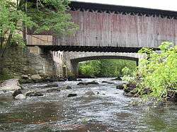
The Contoocook River is a 71-mile-long (114 km)[1] river in New Hampshire. It flows from Pool Pond and Contoocook Lake on the Jaffrey/Rindge border to Penacook (just north of Concord), where it empties into the Merrimack River. It is one of only a few rivers in New Hampshire that flow in a predominantly northward direction. Two picturesque covered bridges in Hopkinton and one in Henniker span the Contoocook, as does another on the Hancock-Greenfield line. Residents and tourists have made the Contoocook popular for fishing and whitewater boating.
The name Contoocook came from the Pennacook tribe of Native Americans and means "place of the river near pines". Other variations of the name include the Abenaki meaning "nut trees river" or Natick language meaning "small plantation at the river".[2][3]
The river gives its name to Contoocook, New Hampshire, a census-designated place (CDP) within the town of Hopkinton.
Principal tributaries
From south to north:
- Nubanusit Brook begins at Nubanusit Lake in Nelson and joins the Contoocook in Peterborough.
- The North Branch of the Contoocook starts in Stoddard and joins the main stem in Hillsborough.
- The Warner River starts in Bradford and joins the Contoocook in Hopkinton.
- The Blackwater River begins at Pleasant Lake in New London and joins the Contoocook in Hopkinton.
See also
References

- ↑ New Hampshire GRANIT state geographic information system Archived August 3, 2013, at the Wayback Machine.
- ↑ Coolidge, Austin J.; John B. Mansfield (1859). A History and Description of New England. Boston, Massachusetts. pp. 424–426.
- ↑ Day, Gordon M.; Michael K. Foster; William Cowan (1998). In Search of New England's Native Past. United States of America. pp. 61–64.
External links
- NH Department of Environmental Services The Contoocook and North Branch Rivers
- American Whitewater description of the Freight Train rapids section