Coningsby
| Coningsby | |
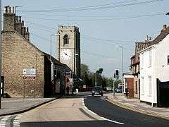 High Street (A153) |
|
 Coningsby |
|
| Area | 14.67 km2 (5.66 sq mi) |
|---|---|
| Population | 3,864 [1] |
| – density | 263/km2 (680/sq mi) |
| OS grid reference | TF2258 |
| – London | 110 mi (180 km) S |
| District | East Lindsey |
| Shire county | Lincolnshire |
| Region | East Midlands |
| Country | England |
| Sovereign state | United Kingdom |
| Post town | LINCOLN |
| Postcode district | LN4 |
| Dialling code | 01526 |
| Police | Lincolnshire |
| Fire | Lincolnshire |
| Ambulance | East Midlands |
| EU Parliament | East Midlands |
| UK Parliament | Louth and Horncastle |
|
|
Coordinates: 53°06′18″N 0°10′31″W / 53.1051°N 0.1752°W
Coningsby /ˈkʌnɪŋzbɪ/ is a village and civil parish in the East Lindsey district in Lincolnshire, England.[2]
Governance
Coningsby is the most populous parish in the electoral ward of Coningsby and Tattershall. The population of this ward taken at the 2011 Census was 6,943.[3]
Geography

The village takes its name from the Old Norse konungr meaning "King" and the Old Norse noun by meaning "settlement", which gives "settlement of the King".[4] Coningsby is about 7 miles (11 km) south of Horncastle on the A153 Horncastle to Sleaford road, with the Lincolnshire Wolds to the west and the Fens to the east. The B1192 Kirton to Woodhall Spa road passes through the village. At the village's western end it is separated from the village of Tattershall by the River Bain. A railway line passing through the village opened on 1 July 1913 but closed on 5 July 1970. The Coldham Road Industrial Estate now occupies the site of the former Coningsby railway station.[2] The line was known officially as the Kirkstead and Little Steeping Railway, though it was universally known by the local people and the railway workers as the "New Line".
Education
Coningsby St Michael's C of E Primary School is on School Lane. The secondary school is Barnes Wallis Academy, the Gartree Community School, is just outside the Coningsby boundary in Tattershall, near the A153. Queen Elizabeth's Grammar School, Horncastle provides sixth form education to pupils graduating from Gartree and other secondary modern schools. RAF Coningsby Nursery and Kids Club provides childcare for military personnel and the community.
The nearest further education college is in Boston. In late March 2008, renovation of the Tattershall/Coningsby Library included a small learning centre provided by Boston College.
Parish church
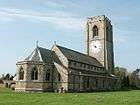
Coningsby is overlooked by the tower of its 15th-century parish church, St Michael's, with its one-handed clock face. One of the few in the country (there is another at St Andrew's in Holt, Norfolk). The face is painted directly onto the wall of the tower and was probably installed in the 17th century. It is 16½ feet (5 metres) in diameter and its hand is nearly 9 feet (2.7 metres) long. The driving weights are large stones and its pendulum swings once every two seconds. The pendulum is not attached to the clock but some distance away, linked by a connecting rod. There are three wheels in the timekeeping mechanism, which needs winding once a day. The tower on which the clock face is painted is on the outside of the building. There is an arched passage under the tower which is part of a public footpath from the A153 High Street to the school in School Lane, through the churchyard.
There is also a canonical sundial, dating from the 12th century, on the south wall of the church.
Britain's youngest Poet Laureate, Laurence Eusden, was buried at St Michael and All Angels' church, where he had been Rector.
Amenities
Public houses include the Black Swan and the White Bull, both on High Street, and the Lea Gate Inn on Leagate Road (B1192).
RAF Coningsby

Half a mile (1 km) to the south of the village is RAF Coningsby, one of the Royal Air Force's most important stations, home of No. 3 Squadron, No. XI Squadron, No. 29 Squadron and No.41 (R) Squadron
The airfield houses part of Britain's heritage, the Battle of Britain Memorial Flight formed in 1957 to commemorate the Royal Air Force's major battle honours, with a Lancaster, five Spitfires, two Hurricanes and a Dakota. These aircraft still fly and can be seen at air shows during summer.[5]
From 1950 RAF Coningsby was home to three squadrons of Washingtons, the RAF name for the American B29 bombers, and for the first 18 months these were maintained by National Service technicians whose conscription was extended to 24 months because of their particular skills.
Economy
Pellcroft Engineering Ltd, located in Coningsby, is a company selling agricultural fans.[6]
References
- ↑ Census, 2011
- 1 2 Ordnance Survey: Landranger map sheet 122 Skegness & Horncastle (Map). Ordnance Survey. 2013. ISBN 9780319229392.
- ↑ "Coningsby and Tattershall ward population 2011". Retrieved 18 August 2015.
- ↑ Mills, A.D. (2011) [first published 1991]. A Dictionary of British Place Names (First edition revised 2011 ed.). Oxford: Oxford University Press. p. 128. ISBN 9780199609086.
- ↑ "Welcome to RAF BBMF", RAF BBMF. Retrieved 9 July 2013
- ↑ "Pellcroft Engineering Limited". www.pellcroft.com. Retrieved 1 April 2016.
External links
 Media related to Coningsby at Wikimedia Commons
- Coningsby Town Council
- "St Michael & All Angels, Coningsby", Geograph.org.uk
- "River Bain, Coningsby", Geograph.org.uk
- "Railway Bridge at Coningsby", Geograph.org.uk
England Portal | |
| Unitary authorities | |
| Boroughs or districts | |
| Major settlements |
|
| Topics | |