List of counties in Connecticut
| Counties of Connecticut | |
|---|---|
 | |
| Location | State of Connecticut |
| Number | 8 |
| Populations | 118,428 (Windham) – 916,829 (Fairfield) |
| Areas | 369 square miles (960 km2) (Middlesex) – 920 square miles (2,400 km2) (Litchfield) |
| Government | County government (abolished in 1960) |
| Subdivisions | cities, towns, unincorporated communities, census designated place |
This is a list of counties in Connecticut. There are currently eight counties in the U.S. state of Connecticut. Four of them were created in 1666, shortly after the Connecticut Colony and the New Haven Colony combined. Two additional counties were created later in the colonial era, and two more counties, Middlesex and Tolland, were created after American independence (both in 1785). Six of the counties are named for locations in England, where many early Connecticut settlers originated.[1]
Although Connecticut is divided into counties, there is no county government in Connecticut and local government consists of cities and towns.[2][3] County government was abolished in Connecticut in 1960, although the names remain for geographical purposes. Counties are, however, still used by the state to organize its judicial and state marshal system. Connecticut's court jurisdictions still adhere to the county boundaries, except for Fairfield, Hartford and New Haven, which have been further subdivided into several jurisdictions.
The FIPS county code is the five-digit Federal Information Processing Standard (FIPS) code which uniquely identifies counties and county equivalents in the United States. The three-digit number is unique to each individual county within a state, but to be unique within the entire United States, it must be prefixed by the state code. This means that, for example, while Fairfield County, Connecticut is 001, Belknap County, New Hampshire and Alachua County, Florida are also 001. To uniquely identify Fairfield County, Connecticut, one must use the state code of 09 plus the county code of 001; therefore, the unique nationwide identifier for Fairfield County, Connecticut is 09001. The links in the column FIPS County Code are to the Census Bureau Info page for that county.[4]
Alphabetical listing
| County |
FIPS County Code [4] |
County seat (defunct) [5] |
Established [5] |
Origin [1] |
Etymology [6] |
Population [5][7] |
Area [5] |
Map |
|---|---|---|---|---|---|---|---|---|
| Fairfield County | 001 | Fairfield (1666–1853) Bridgeport (1853–1960) | 1666 | One of four original counties created in Connecticut | From the hundreds of acres of salt marsh that bordered the coast. | 916,829 | 626 sq mi (1,621 km2) | 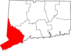
|
| Hartford County | 003 | Hartford (1666–1960) | 1666 | One of four original counties created in Connecticut | After the county of Hertfordshire in the UK | 894,014 | 736 sq mi (1,906 km2) | 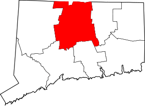
|
| Litchfield County | 005 | Litchfield (1751–1960) | 1751 | From parts of Fairfield County, Hartford County, and New Haven County | City of Lichfield in the UK | 189,927 | 920 sq mi (2,383 km2) | 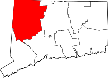
|
| Middlesex County | 007 | Middletown (1785–1960) | 1785 | From parts of Hartford County and New London County | Former county of Middlesex in the UK | 165,676 | 369 sq mi (956 km2) | 
|
| New Haven County | 009 | New Haven (1666–1960) | 1666 | One of four original counties created in Connecticut | After New Haven Colony, founded as a haven in which Puritans could be free from persecution. | 862,477 | 606 sq mi (1,570 km2) | 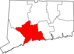
|
| New London County | 011 | New London (1666–1960) | 1666 | One of four original counties created in Connecticut | After London, UK | 274,055 | 666 sq mi (1,725 km2) | 
|
| Tolland County | 013 | Tolland (1785–1889) Rockville (1889–1960) | 1785 | From parts of Hartford County, and Windham County | Hamlet of Tolland, Somerset, UK | 152,691 | 410 sq mi (1,062 km2) | 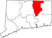
|
| Windham County | 015 | Windham (1726–1819) Brooklyn (1819–1895) Willimantic and Putnam (1895–1960) | 1726 | From parts of Hartford County, and New London County | After Windham (now Wineham) in Sussex, England | 118,428 | 513 sq mi (1,329 km2) | 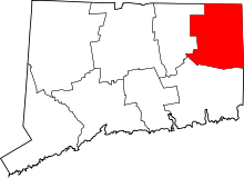 |
Former counties
- Trumbull County, Ohio – The Connecticut Western Reserve, ceded to Ohio in 1800.
- Westmoreland County, Connecticut – An area around Wilkes-Barre, ceded to Pennsylvania in 1784.
References
- 1 2 Clark, George Larkin (1914). A History of Connecticut, Its People and Institutions. G.P. Putnam & Sons.
- ↑ "About Connecticut". CT.gov. Retrieved 2007-07-17.
- ↑ An Overview of County Government, National Association of Counties website, accessed 5 January 2008
- 1 2 "EPA County FIPS Code Listing". EPA.gov. Retrieved 2008-02-23.
- 1 2 3 4 National Association of Counties. "NACo – Find a county". Archived from the original on 27 September 2007. Retrieved 2008-04-30.
- ↑ Beatty, Michael (2001). County Name Origins of the United States. McFarland Press. ISBN 0-7864-1025-6.
- ↑ "Connecticut QuickFacts". U.S. Census Bureau. Retrieved 2007-07-17.
