Conlin–Whitehead Highway
| Conlin–Whitehead Highway | ||||
|---|---|---|---|---|
| State Road 598 | ||||
|
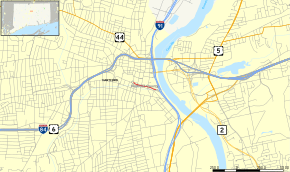
Map of Hartford in central Connecticut with Whitehead Highway highlighted in red | ||||
| Route information | ||||
| Maintained by ConnDOT | ||||
| Length: | 0.67 mi (1.08 km) | |||
| Existed: | 1984 – present | |||
| Major junctions | ||||
| East end: |
| |||
| West end: | Pulaski Circle in Hartford | |||
| Location | ||||
| Counties: | Hartford | |||
| Highway system | ||||
| ||||
The Whitehead Highway (also variously known as Conlin–Whitehead Highway and Conland-Whitehead Highway), is a short 0.67-mile (1.08 km) spur from Interstate 91 (I-91) in Hartford, Connecticut leading to the State Capitol at Pulaski Circle. Constructed above the Park River Conduit, the highway underwent rehabilitation from 2004–2005.
Route description

It is signed as "Exit 29A – Capitol Area" on I-91 and has the unsigned designation of State Road 598 (SR 598). There are two intermediate exits (at Columbus Boulevard and Prospect Street) from the highway before its western terminus at Pulaski Circle.
History
| |
|---|---|
| Location: | Hartford, Connecticut |
| Existed: | 1968–1983 |
Whitehead Highway was originally to be part of Interstate 484, an auxiliary route of I-84. The highway was to be upgraded via straightening and bridge improvements and brought through a short tunnel under the state capitol to connect to I-84 at exit 48. This would have reduced the traffic load at the intersection of I-91 and I-84 in downtown Hartford. The extension, first proposed in 1968, was cancelled in 1983. The route was never signed as I-484.
The Whitehead Highway was named after Ulmont I. "Monty" Whitehead, Jr., the first resident of Connecticut to die in World War II. Whitehead, a 1933 graduate of Bulkeley High School in Hartford, graduated in 1940 from the U.S. Naval Academy, where he starred in football. On December 7, 1941, Whitehead was serving at Pearl Harbor on the battleship U.S.S. Arizona, which blew up and sank in the opening minutes of the Japanese attack, killing Whitehead and 1,176 other sailors.[1][2]
Junction list
The entire route is in Hartford, Hartford County. All exits are unnumbered.
| mi[3] | km | Destinations | Notes | ||
|---|---|---|---|---|---|
| 0.00 | 0.00 | Eastern terminus | |||
| 0.46 | 0.74 | Columbus Boulevard – Connecticut Convention Center | Westbound exit and eastbound entrance | ||
| 0.60 | 0.97 | Prospect Street / Arch Street to Main Street | Westbound exit and eastbound entrance | ||
| 0.76 | 1.22 | Pulaski Circle | Western terminus of SR 598 | ||
| 1.000 mi = 1.609 km; 1.000 km = 0.621 mi | |||||
See also
 Connecticut portal
 U.S. Roads portal
References
- ↑ "I-484". Kurumi.
- ↑ "Interstate 484 - Connecticut". Roads of Metro New York.
- ↑ McGaughey, Owen (2006). "CT 598 (Conland-Whitehead Highway) Exit List". Nutmeg Roads. Retrieved December 7, 2011.